
Wadi Qabbani
وادي قباني | |
|---|---|
 1870s map 1870s map  1940s map 1940s map modern map modern map  1940s with modern overlay map 1940s with modern overlay mapA series of historical maps of the area around Wadi Qabbani (click the buttons) | |
 Wadi Qabbani Location within Mandatory Palestine | |
| Coordinates: 32°21′44″N 34°55′18″E / 32.36222°N 34.92167°E | |
| Palestine grid | 142/196 |
| Geopolitical entity | Mandatory Palestine |
| Subdistrict | Tulkarm |
| Date of depopulation | Not known[3] |
| Area | |
| • Total | 9,812 dunams (9.812 km2 or 3.788 sq mi) |
| Population (1945) | |
| • Total | 320[1][2] |
| Current Localities | HaOgen[4] |
Wadi Qabbani (Arabic: وادي قباني), also known as Khirbat ash Sheik Husein (Arabic: خربة الشيخ حسين) was a Palestinian Arab village in the Tulkarm Subdistrict. It was probably depopulated during the 1947–48 Civil War in Mandatory Palestine on March 1, 1948, as part of Operation Coastal Clearing. It was located 12 km northwest of Tulkarm. The name, Qabbani came from the Lebanese family who owned most of the land.
YouTube Encyclopedic
-
1/5Views:159 5491 96943 2021 8841 263
-
Benarkah Habib Umar Sesat ? | Ustaz Muhaizad Bin Muhammad
-
“A Poem About The Reality of Death; The Destroyer of All Pleasures” (Arabic/English)
-
Isu Tarikat Naqsyabandi - Ustaz Muhammad Fawwaz
-
E33 Bilal Al Habashi r & the Secret Realities of the Heart Sufi Meditation Center
-
Love is All I Have
Transcription
History
British Mandate era
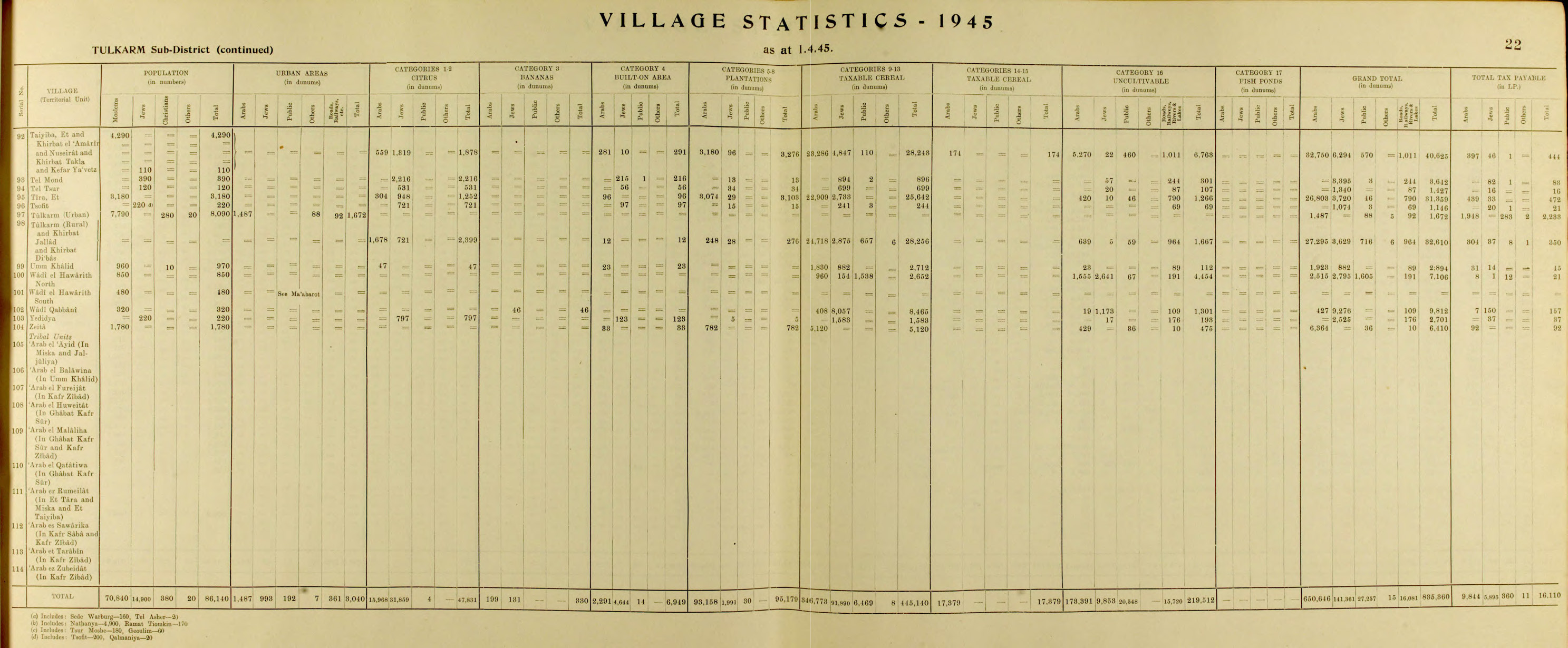
In the 1945 statistics the village had a total population of 210 Muslims[1] with a total of 9,812 dunams of land.[2]
The land ownership of the village before occupation in dunams:[1][2]
| Owner | Dunams |
|---|---|
| Arab | 427 |
| Jewish | 9,276 |
| Public | 109 |
| Total | 9,812 |
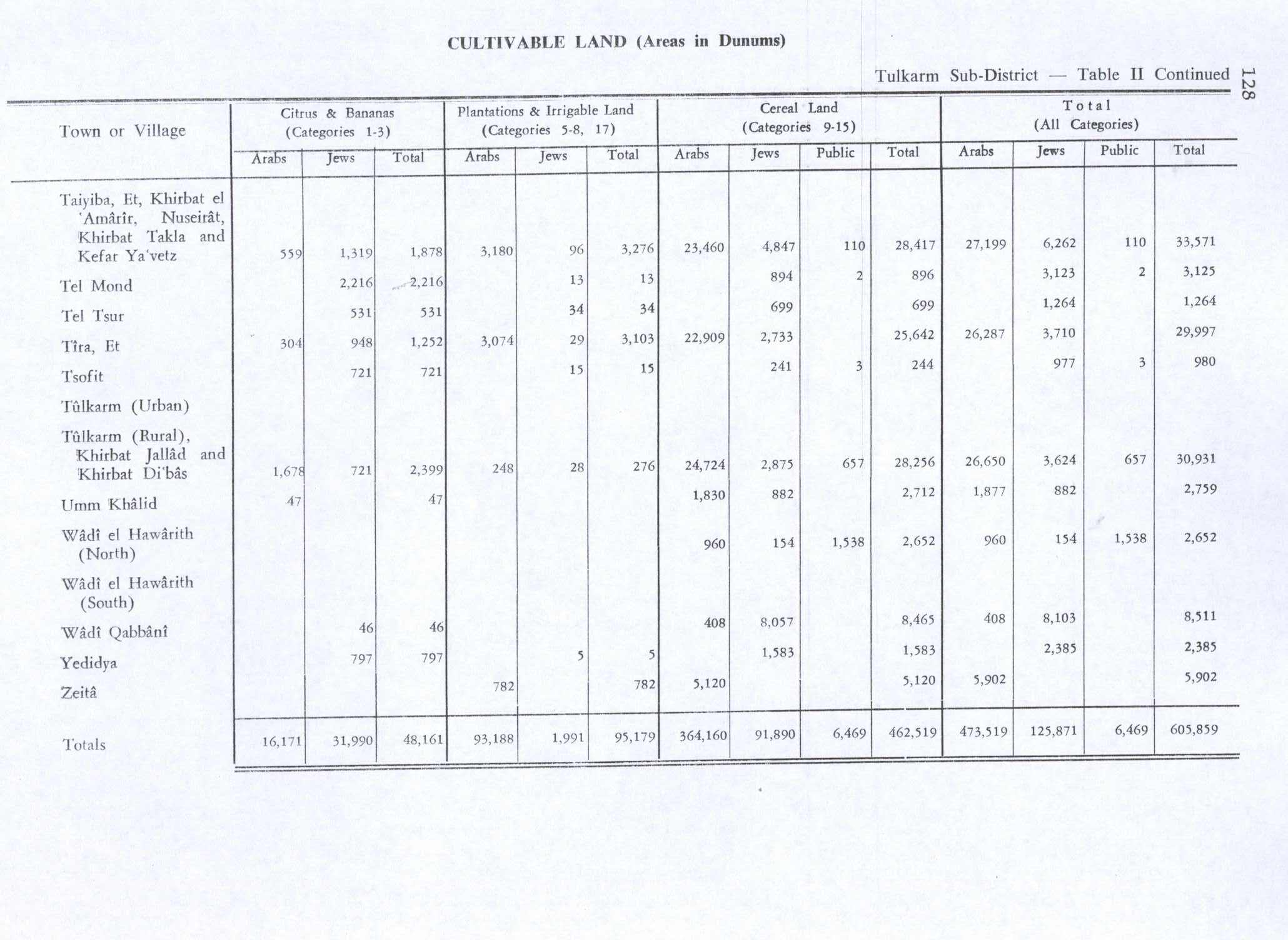
Of this, Arabs used 408 dunums for cereals,[5] while a total of 1,301 dunams were classified as non-cultivable land.[6]
Types of land use in dunams in the village in 1945:[5][6]
| Land Usage | Arab | Jewish | Public |
|---|---|---|---|
| Citrus and bananas | - | 46 | - |
| Irrigated and plantation | - | - | - |
| Cereal | 408 | 8,057 | - |
| Urban | - | - | - |
| Cultivable | 408 | 8,103 | - |
| Non-cultivable | 19 | 1,173 | 109 |
References
- ^ a b c Department of Statistics, 1945, p. 22
- ^ a b c d Government of Palestine, Department of Statistics. Village Statistics, April, 1945. Quoted in Hadawi, 1970, p. 77
- ^ Morris, 2004, p. xviii, village #186. Gives both date and cause of depopulation as "Not known"
- ^ Khalidi, 1992, p. 566
- ^ a b Government of Palestine, Department of Statistics. Village Statistics, April, 1945. Quoted in Hadawi, 1970, p. 128
- ^ a b Government of Palestine, Department of Statistics. Village Statistics, April, 1945. Quoted in Hadawi, 1970, p. 178
Bibliography
- Department of Statistics (1945). Village Statistics, April, 1945. Government of Palestine.
- Hadawi, S. (1970). Village Statistics of 1945: A Classification of Land and Area ownership in Palestine. Palestine Liberation Organization Research Center.
- Khalidi, W. (1992). All That Remains: The Palestinian Villages Occupied and Depopulated by Israel in 1948. Washington D.C.: Institute for Palestine Studies. ISBN 0-88728-224-5.
- Morris, B. (2004). The Birth of the Palestinian Refugee Problem Revisited. Cambridge University Press. ISBN 978-0-521-00967-6.
External links
- Welcome To Wadi Qabbani
- Wadi Qabbani, Zochrot
- Survey of Western Palestine, Map 10: IAA, Wikimedia commons
