
Wadi Fira
وادي فيرا | |
|---|---|
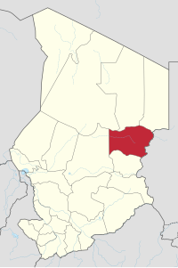 Map of Chad showing Wadi Fira. | |
| Coordinates: 14°31′39″N 20°55′36″E / 14.52750°N 20.92667°E | |
| Country | Chad |
| Departments | 3 |
| Sub-prefectures | 10 |
| Region as of | 2002 |
| Regional capital | Biltine |
| Government | |
| • Gouverneur | Ahmadou Ahidjo N'Garo (2010)[1] |
| Population (2009)[2] | |
| • Total | 508,383 |
| ISO 3166 code | TD-WF[3] |
Wadi Fira (Arabic: وادي فيرا)[4] is one of the 23 regions of Chad. Its capital is the town of Biltine.[5] The region corresponds with the former prefecture of Biltine.[6]
Geography

The region borders Borkou Region, Ennedi-Ouest Region and Ennedi-Est Region to the north, Sudan to the east, Ouaddaï Region to the south, and Batha Region to the west. The terrain is savannah merging into the Sahara Desert in the north, and rising to the east.
Settlements
Biltine is the region's capital; other major settlements include Guéréda, Iriba and Matadjana.[7]
Demographics
As per the 2009 Chadian census, Wadi Fira's population is 508,383.[2] The main ethnolinguistic groups are the Amdang, Baggara (generally speakers of Chadian Arabic), Maba, Mararit, Tama and Zaghawa.[8]
Subdivisions
The region of Wadi Fira is divided into three departments, each listed with the name of its capital or main town (chef-lieu in French) and a list of sub-prefectures (sous-préfectures).[4][5]
| Department | Capital (chef-lieu) | Sub-prefectures |
|---|---|---|
| Biltine | Biltine | Am Zoer, Arada, Biltine, Mata |
| Dar Tama | Guéréda | Guéréda, Kolonga, Sirim Birke |
| Kobé | Iriba | Iriba, Matadjana, Tiné Djagaraba |
References
- ^ Décret n° 794/PR/PM/MISP/2010. Republique du Tchad. 30 September 2010.
- ^ a b DEUXIEME RECENSEMENT GENERAL DE LA POPULATION ET DE L’HABITAT: RESULTATS GLOBAUX DEFINITIFS (PDF) (Report). INSEED. March 2012. p. 24. Retrieved 10 March 2017.
- ^ "ISO 3166-2 Newsletter No. II-2" (PDF). ISO. 30 June 2010.
- ^ a b "Décret 10-371 2010-04-02 PR/PM/2010: Décret portant désignation des Présidents des démembrements de la Commission Électorale Nationale Indépendante" [Decree appointing the presidents of branches of the Independent National Electoral Commission]. Légitchad (in French). Republique du Tchad. 2 April 2010. Archived from the original on 24 February 2013.
- ^ a b "Profil National du Tchad sur la gestion des produits chimiques, Troisieme Edition" [National Profile of Chad on Chemicals Management, Third Edition] (PDF). ESTIS.net (in French). Republique du Tchad - Ministere de l'Environnement et des Ressources Halieutiques. September 2009. Archived from the original on 1 March 2014.
- ^ Décret n° 419/PR/MAT/02. Republique du Tchad. 17 October 2002. (concerning the creation of the régions)
- ^ "Tchad : Région du Wadi Fira (novembre 2016)" (PDF). UNOCHA. Retrieved 28 September 2019.
- ^ "Languages of Chad". Ethnologue. Retrieved 27 September 2019.
| ||
This Chad location article is a stub. You can help Wikipedia by expanding it. |