
Vredefort | |
|---|---|
 Nederduitse Gereformeerde Church, Church Street, Vredefort | |
 Coat of arms | |
 Vredefort  Vredefort | |
| Coordinates: 27°01′S 27°23′E / 27.017°S 27.383°E | |
| Country | South Africa |
| Province | Free State |
| District | Fezile Dabi |
| Municipality | Ngwathe |
| Established | 1878[1] |
| Area | |
| • Total | 21.4 km2 (8.3 sq mi) |
| Population (2011)[2] | |
| • Total | 14,619 |
| • Density | 680/km2 (1,800/sq mi) |
| Racial makeup (2011) | |
| • Black African | 92.4% |
| • Coloured | 2.1% |
| • Indian/Asian | 0.3% |
| • White | 5.0% |
| • Other | 0.3% |
| First languages (2011) | |
| • Sotho | 68.9% |
| • Xhosa | 15.7% |
| • Afrikaans | 7.7% |
| • Zulu | 1.6% |
| • Other | 6.0% |
| Time zone | UTC+2 (SAST) |
| Postal code (street) | 9595 |
| PO box | 9595 |
| Area code | 056 |
Vredefort (locally /ˈfrɪərdəfɔːrt/, Afrikaans: [ˈfriədəfɔrt]) is a small farming town in the Free State province of South Africa with cattle, peanuts, sorghum, sunflowers and maize being farmed. It is home to 3,000 residents.
The town was established in 1876 on a farm called Visgat, on the Vredefort impact structure, the largest and oldest visible bolide impact crater in the world (with a diameter of 300 kilometres (190 mi)). It was this approximately 10-kilometre (6.2 mi) wide bolide that led to the preservation of the gold-bearing reefs of the Free State some 2.02 billion years ago. The town's name, which translates to "peace fort" in Afrikaans and Dutch, was derived from the peaceful conclusion to a threatened war between the Transvaal and the Orange Free State. The British built a concentration camp here during the Second Boer War to house Boer women and children.
The Vredefort Dome is currently the largest and one of the oldest known asteroid impact sites in the world.[3] It is South Africa's seventh World Heritage Site and its status is largely due to the efforts of research scientists from Wits University.[4]
YouTube Encyclopedic
-
1/3Views:3 70610 9431 235
-
VREDEFORT DOME - FOOTPRINTS OF THE PAST
-
Vredefort crater
-
VREDEFORT DOME - ORIGINS
Transcription
Notable residents
See also
References
- ^ Robson, Linda Gillian (2011). "Annexure A" (PDF). The Royal Engineers and settlement planning in the Cape Colony 1806–1872: Approach, methodology and impact (PhD thesis). University of Pretoria. pp. xlv–lii. hdl:2263/26503.
- ^ a b c d Sum of the Main Places Vredefort and Mokwallo from Census 2011.
- ^ Earth Impact Database
- ^ Information The Vredefort Dome Homepage
External links
Municipalities and communities of Fezile Dabi District Municipality, Free State | ||
|---|---|---|
District seat: Sasolburg | ||
| Moqhaka | 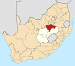 | |
| Ngwathe | ||
| Metsimaholo | ||
| Mafube | ||
| International | |
|---|---|
| National | |
This Free State location article is a stub. You can help Wikipedia by expanding it. |