

The Vindelici (Gaulish: *Uindelicoi) were a Gallic people dwelling around present-day Augsburg (Bavaria) during the Iron Age and the Roman period.
YouTube Encyclopedic
-
1/3Views:4 0227 34567 669
-
Pyrrhus of Pyrrhidae-the Molossian
-
REITIA - Dea dei Veneti
-
83-6.a.-2/5 Kroniki niemieckie, rzymskie i arabskie o Imperium Lechitów i antyczne nazwy Polaków.
Transcription
Name
They are mentioned as Vindĕlĭcī by Horace (1st c. BC),[1] as Ouindolikoì (Οὐινδολικοὶ; var. Οὐι(ν)δολίγοι) by Strabo (early 1st c. AD),[2] as Vindelici and Vindelicorum (var. uendili-, uidelicino-, uideliquo-) by Pliny (1st c. AD),[3] as Vindelicorumque by Tacitus (early 2nd c. AD),[4] and as Vindelicorum and Vindolici on inscriptions.[5][6]
The ethnonym Vindelicī a latinized form of Gaulish *Uindelicoi (sing. *Uindelicos). It derives from the stem *uindo- ('clear, white, bright'), probably after the name of an unattested river *Uindelis or *Uindelos.[7][8] A hydronym Vindelicus is mentioned by Florus as an alternative name of the Soulgas (Sorgue), in southeastern France.[6] Alternatively, Patrizia de Bernardo Stempel has proposed to translate the name as 'those from the white rocks', by deriving the second element from Gaulish lica ('flat stone').[9]
Geography
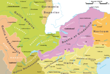
The Vindelici lived on the Upper Bavarian-Upper Swabian plateau, probably also in Vorarlberg and Tyrol, in a land stretching from the southern slopes of the Alps up to the Danube river.[10][11] They later occupied the eastern part of the province of Raetia, in a region known by Ptolemy as Vindelicia.[12][11] Their territory was located west of the Catenates, south of the Raetovarii, north of the Licates.[13]
Their chief town during the Roman period was known as Augusta Vindelicum or Aelia Augusta (modern Augsburg).[14] A first Roman military camp was occupied from 10 BC up until ca. 15 AD, when it was probably destroyed by flooding and relocated to the south. The second fort, abandoned in the 70–80s, was rapidly covered by the expanding civilian settlement. Augusta Vindelicum served at a time as the capital of Raetia and the residence of the provincial governor. It obtained the status of municipium under the emperor Hadrian (117–138 AD). From the reign of Diocletian (284–305), the city became the capital of Raetia secunda.[14]
Political organization
In the narrow sense, the Vindelician people comprised four sub-tribes, listed on the Tropaeum Alpium: the Cosuanetes, Rucinates, Licates and Catenates.[8]
In a broader sense, they included, as counted by Strabo, the Licates, Clautenatii, Vennones, Estiones, and Brigantii,[10] although this classification has been criticized as doubtful by some scholars.[8] Rather than sub-tribes, they may have rather been pagi or clients of the Vindelici.[12]
Despite the proximity of Augusta Vindelicum, the Vindelici were only partially Romanized.[11]
History
They are mentioned by Pliny the Elder as one of the Alpine tribes conquered by Rome in 16–15 BC, and whose name was engraved on the Tropaeum Alpium.[3]
Early on, the Vindelici served as auxiliary soldiers in the Roman army, in the cohortes Raetorum et Vindelicorum.[8]
See also
References
- ^ Horace. Carm., 4:4:17–18, 14:7–9.
- ^ Strabo. Geōgraphiká, 4:3:3.
- ^ a b Pliny. Naturalis Historia, 3:20.
- ^ Tacitus. Annal., 2:17.
- ^ CIL 3:1343, 3:3562, 5:4910, 9:30:44, 13:6495, 13:5905, 13:6821, 13:7573, etc.
- ^ a b Falileyev 2010, s.v. Vindelici.
- ^ Delamarre 2003, p. 320.
- ^ a b c d Schumacher, Dietz & Zanier 2007.
- ^ de Bernardo Stempel 2015, p. 89.
- ^ a b Waldherr 2006.
- ^ a b c Wilkes & Drinkwater 2015.
- ^ a b Kruta 2000, p. 862.
- ^ Talbert 2000, Map 12: Mogontiacum-Reginum-Lauriacum.
- ^ a b Kiernan 2012.
Primary sources
- Pliny (1938). Natural History. Loeb Classical Library. Translated by Rackham, H. Harvard University Press. ISBN 978-0674993648.
- Strabo (1923). Geography. Loeb Classical Library. Translated by Jones, Horace L. Harvard University Press. ISBN 978-0674990562.
- Tacitus (1925). Histories. Loeb Classical Library. Translated by Moore, Clifford H. Harvard University Press. ISBN 978-0674991231.
Bibliography
- de Bernardo Stempel, Patrizia (2015). "Zu den keltisch benannten Stämmen im Umfeld des oberen Donauraums". In Lohner-Urban, Ute; Scherrer, Peter (eds.). Der obere Donauraum 50 v. bis 50 n. Chr. Frank & Timme. ISBN 978-3-7329-0143-2.
- Delamarre, Xavier (2003). Dictionnaire de la langue gauloise: Une approche linguistique du vieux-celtique continental. Errance. ISBN 9782877723695.
- Falileyev, Alexander (2010). Dictionary of Continental Celtic Place-names: A Celtic Companion to the Barrington Atlas of the Greek and Roman World. CMCS. ISBN 978-0955718236.
- Kiernan, Philip (2012). "Augusta Vindelicum (Augsburg)". In Bagnall, Roger S (ed.). The Encyclopedia of Ancient History. John Wiley & Sons, Inc. ISBN 978-1-4443-3838-6.
- Kruta, Venceslas (2000). Les Celtes, histoire et dictionnaire : des origines à la romanisation et au christianisme. Robert Laffont. ISBN 2-221-05690-6.
- Schumacher, Stefan; Dietz, Karlheinz; Zanier, Werner (2007). "Vindeliker". In Beck, Heinrich (ed.). Reallexikon der Germanischen Altertumskunde. Vol. 35 (2 ed.). De Gruyter. ISBN 978-3110187847.
- Talbert, Richard J. A. (2000). Barrington Atlas of the Greek and Roman World. Princeton University Press. ISBN 978-0691031699.
- Waldherr, Gerhard H. (2006). "Vindelici". Brill's New Pauly. doi:10.1163/1574-9347_bnp_e12204900.
- Wilkes, John; Drinkwater, John Frederick (2015). "Vindelici". Oxford Research Encyclopedia of Classics. doi:10.1093/acrefore/9780199381135.013.6814. ISBN 978-0-19-938113-5.
