To install click the Add extension button. That's it.

The source code for the WIKI 2 extension is being checked by specialists of the Mozilla Foundation, Google, and Apple. You could also do it yourself at any point in time.

4,5
Kelly Slayton
Congratulations on this excellent venture… what a great idea!
Alexander Grigorievskiy
I use WIKI 2 every day and almost forgot how the original Wikipedia looks like.
Live Statistics
English Articles
Improved in 24 Hours
Added in 24 Hours
Languages
Recent
Show all languages
What we do. Every page goes through several hundred of perfecting techniques; in live mode. Quite the same Wikipedia. Just better.
.
Leo
Newton
Brights
Milds

Varadero Point

From Wikipedia, the free encyclopedia

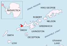
Location of Byers Peninsula, Livingston Island in the South Shetland Islands
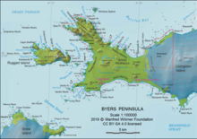
Topographic map of Antarctic Specially Protected Area ASPA 126 Byers Peninsula
Topographic map of Livingston Island, Greenwich, Robert, Snow and Smith Islands

Varadero Point is a point projecting 620 m into Barclay Bay from Robbery Beaches on Byers Peninsula, Livingston Island in the South Shetland Islands, Antarctica and forming the west side of the entrance to Baba Tonka Cove. Dominated by Varadero Hill (116 m).

The point is named descriptively ('Boathouse Point') from being an area where icebergs get stranded.

Location

The point is located at 62°36′26.9″S 61°04′40.7″W / 62.607472°S 61.077972°W / -62.607472; -61.077972 which is 6.46 km southeast of Essex Point and 1.19 km west-northwest of Villard Point (British mapping in 1968, detailed Spanish mapping in 1992, and Bulgarian mapping in 2005 and 2009).

Maps

  • Península Byers, Isla Livingston. Mapa topográfico a escala 1:25000. Madrid: Servicio Geográfico del Ejército, 1992.
  • L.L. Ivanov et al. Antarctica: Livingston Island and Greenwich Island, South Shetland Islands. Scale 1:100000 topographic map. Sofia: Antarctic Place-names Commission of Bulgaria, 2005.
  • L.L. Ivanov. Antarctica: Livingston Island and Greenwich, Robert, Snow and Smith Islands. Scale 1:120000 topographic map. Troyan: Manfred Wörner Foundation, 2009. ISBN 978-954-92032-6-4

References


This page was last edited on 19 April 2022, at 21:15
Basis of this page is in Wikipedia. Text is available under the CC BY-SA 3.0 Unported License. Non-text media are available under their specified licenses. Wikipedia® is a registered trademark of the Wikimedia Foundation, Inc. WIKI 2 is an independent company and has no affiliation with Wikimedia Foundation.