
| Vaigai River | |
|---|---|
 | |
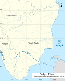 Map of Vaigai river | |
| Etymology | … |
| Location | |
| Country | India |
| . | |
| Physical characteristics | |
| Source | Varusanadu Hills |
| • location | Tamil Nadu, India |
| Mouth | |
• location | Palk Bay, India |
• elevation | 0 m (0 ft) |
| Length | 258 km (160 mi) |
| Discharge | |
| • average | 36 m3/s (1,300 cu ft/s) |
| Discharge | |
| • location | Peranai[1] |
| • average | 28.8 m3/s (1,020 cu ft/s) |
Vaigai River | ||||||||||||||||||||||||||||||||||||||||||||||||||||||||||||||||||||||||||||||||||||||||||||||||||||||||||||||||||||||||||||||||||||||||||||||||||||||||||||||||||||||||||||||||||||||||||||||||||||||||||||||||||||||||||||||||
|---|---|---|---|---|---|---|---|---|---|---|---|---|---|---|---|---|---|---|---|---|---|---|---|---|---|---|---|---|---|---|---|---|---|---|---|---|---|---|---|---|---|---|---|---|---|---|---|---|---|---|---|---|---|---|---|---|---|---|---|---|---|---|---|---|---|---|---|---|---|---|---|---|---|---|---|---|---|---|---|---|---|---|---|---|---|---|---|---|---|---|---|---|---|---|---|---|---|---|---|---|---|---|---|---|---|---|---|---|---|---|---|---|---|---|---|---|---|---|---|---|---|---|---|---|---|---|---|---|---|---|---|---|---|---|---|---|---|---|---|---|---|---|---|---|---|---|---|---|---|---|---|---|---|---|---|---|---|---|---|---|---|---|---|---|---|---|---|---|---|---|---|---|---|---|---|---|---|---|---|---|---|---|---|---|---|---|---|---|---|---|---|---|---|---|---|---|---|---|---|---|---|---|---|---|---|---|---|---|---|---|---|---|---|---|---|---|---|---|---|---|---|---|---|---|
| ||||||||||||||||||||||||||||||||||||||||||||||||||||||||||||||||||||||||||||||||||||||||||||||||||||||||||||||||||||||||||||||||||||||||||||||||||||||||||||||||||||||||||||||||||||||||||||||||||||||||||||||||||||||||||||||||
The Vaigai is a river in the Tamil Nadu state of southern India; it passes through the towns of Theni, Madurai and Ramanathapuram.[2] It originates in Varusanadu Hills, the Periyar Plateau of the Western Ghats range, and flows northeast through the Kambam Valley, which lies between the Palani Hills to the north and the Varushanad Hills to the south. The Vattaparai Falls are located on this river. As it rounds the eastern corner of the Varushanad Hills, the river turns southeast, running through the region of Pandya Nadu. Madurai, the largest city in the Pandya Nadu region and its ancient capital, lies on the Vaigai. The river empties into the Palk Bay near Alagankulam, close to Pamban Bridge in Ramanathapuram District.
The Vaigai is 258 kilometres (160 mi) long, with a drainage basin 7,031 square kilometres (2,715 sq mi) large.[3] This river flows through 5 districts namely Theni, Dindigul, Madurai, Sivagangai and Ramanathapuram and this river Serves as a Lifeline for 6 districts namely Theni, Dindigul, Madurai, Sivagangai, Virudhunagar and Ramanathapuram as farmers of all these districts are greatly depends on this river water.
YouTube Encyclopedic
-
1/3Views:40 71248 8682 278
-
Vaigai river | PYQ | Map In Shorts | StudyIQ IAS Hindi। #upsc #ias #cse #ips
-
Vaigai River | PYQ | Map In Shorts | StudyIQ IAS Hindi। Amrit Upadhyay
-
वैगाई नदी / Vaigai River : Rivers Of India
Transcription
Vaigai in literature
Sangam literature (circa 300 BCE to 300 CE[4][5][6]) has paid many tributes to Vaigai, extolling it as 'the river that brings water when one touches it', viz the etymology Vai (Earth) + yai (sky) = Vaiyai .[7][8]
The following story is told about the birth of the river Vaigai. Koodal Purana details the origin of Vaigai river flowing through Madurai. It is believed that Vishnu stood up as Trivikrama, with one of his feet rising to the skies and the foot reached Brahmaloka, the abode of Brahma. Brahma was pleased to perform ablution to the raised foot and the water is believed to have emerged as a rivulet called Krithimala. As the river came from the sky and fell into Earth it is called Vai which means Vaiyam (Earth) and Yai means coming down hence, the name Vaiyai and later changed into vaigai. It is mentioned as Vaiyai in Paripatal and not Vaigai .[9] A large number of banana trees sprang up in the place and it came to be known as Kadhalivana, a forest of banana trees.[7][8]

It also is mentioned as the Sanskrit name Krithamal by a Pandya king in the following story. Satyavrata, a ruler of Madurai was a staunch devotee of Vishnu. It is believed that once Vishnu came out of the river Krithimala as a fish (Matsya avatar, one of the avatars of Vishnu) to teach Vedas to the ruler. From then on, the Pandyas started using fish as the symbol of the kingdom.[7][8]
Tributaries
The main tributaries of the Vaigai are Siruliar, Theniar, Varaha Nadi, and Mangalar.[10] Vaigai Dam is the major dam in this river which is present in Theni district.[citation needed]
Vaigai gets major feed from the Periyar Dam in Kumili, Kerala. Water from the Periyar River in Kerala is diverted into the Vaigai River in Tamil Nadu via a tunnel through the Western Ghats. In summers, the Vaigai river ends up dry very often. The water never reaches Madurai, let alone flowing into places past Madurai.[citation needed]
Dams

The Vaigai Dam is built across the river in Periyakulam taluk, in the Theni district of Tamil Nadu. It provides water for irrigation for the Theni District, Dindigul District, Madurai district, Sivagangai District, Ramanathapuram District and indirectly serves Virudhunagar District through Irrigation canals from Sivagangai District. It also provides drinking water to Madurai and Andipatti.[11] Near the dam, the Government of Tamil Nadu has constructed an Agricultural Research Station for researching the growing of a variety of crops, including rice, sorghum, blackgram, cowpea and cotton.[12]
The Periyar Dam was built in 1895 by John Pennycuick, who implemented a plan proposed over a century earlier by Pradani Muthirulappa Pillai of Ramnad. The dam was built by the British Army Engineering corps for the Travancore kingdom. The first dam was washed away by floods, and a second masonry dam was constructed in 1895.[citation needed]
See also
References
- ^ "Gauging Station – Data Summary". ORNL. Retrieved 1 October 2013.
- ^ Madurai, Temple Town of South India. Cultural capital of Tamilnadu
- ^ Garg, Santosh Kumar (1999). International and interstate river water disputes. Laxmi Publications. p. 10. ISBN 978-81-7008-068-8. Retrieved 16 May 2011.
- ^ Upinder Singh (2008). A History of Ancient and Early Medieval India: From the Stone Age to the 12th Century. Pearson Education India. pp. 27–28. ISBN 978-81-317-1120-0.
- ^ Nadarajah, Devapoopathy (1994). Love in Sanskrit and Tamil Literature: A Study of Characters and Nature, 200 B.C.-A.D. 500. Motilal Banarsidass Publ. ISBN 978-81-208-1215-4.
- ^ University, Vijaya Ramaswamy, Jawaharlal Nehru (25 August 2017). Historical Dictionary of the Tamils. Rowman & Littlefield. ISBN 978-1-5381-0686-0.
{{cite book}}: CS1 maint: multiple names: authors list (link) - ^ a b c M., Rajagopalan (1993). 15 Vaishnava Temples of Tamil Nadu. Chennai, India: Govindaswamy Printers. pp. 119–128.
- ^ a b c S., Sundararajan (6 September 2004). "Symbol of togetherness". The Hindu. Archived from the original on 27 November 2004. Retrieved 29 October 2015.
- ^ V.N. Muthukumar; Elizabeth Rani Segran (2012). The River Speaks: The Vaiyai Poems from the Paripatal. Penguin Books. pp. 3–11. ISBN 978-81-8475-694-4.
- ^ "Vaigai River | Map, India, & Tributaries | Britannica". www.britannica.com. 18 August 2023. Retrieved 10 September 2023.
- ^ "Water released from Vaigai dam for irrigation". The Hindu. Archived from the original on 25 November 2020. Retrieved 9 August 2007.
{{cite web}}: CS1 maint: unfit URL (link) - ^ "Welcome to Agricultural Research Station, Vaigai Dam". Tamil Nadu Government. Retrieved 9 August 2007.
Further reading
- Tectono-climatic and depositional environmental controls on the Neolithic habitation sites, Vaigai River Basin, Southern India. Geological journal. 08 January 2024. https://doi.org/10.1002/gj.4919
9°21′N 79°00′E / 9.350°N 79.000°E