
Väike-Maarja Parish
Väike-Maarja vald | |
|---|---|
 Kiltsi manor | |
 Flag  Coat of arms | |
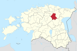 Väike-Maarja Parish within Lääne-Viru County. | |
| Country | |
| County | Lääne-Viru County |
| Administrative centre | Väike-Maarja |
| Area | |
| • Total | 457.39 km2 (176.60 sq mi) |
| Population (01.01.2009) | |
| • Total | 5,421 |
| • Density | 12/km2 (31/sq mi) |
| ISO 3166 code | EE-928 |
| Website | www.v-maarja.ee |
Väike-Maarja Parish (Estonian: Väike-Maarja vald) is a rural municipality of Estonia, in Lääne-Viru County. It has a population of 5,421 (as of 1 January 2009) and an area of 457.39 km².[1]
Settlements
- Small boroughs
Kiltsi, Rakke, Simuna, Väike-Maarja
- Villages
Aavere - Aburi - Äntu - Ärina - Avanduse - Avispea - Ebavere - Edru - Eipri - Emumäe - Hirla - Imukvere - Jäätma - Kaavere - Kadiküla - Kamariku - Kännuküla - Kärsa - Käru - Kellamäe - Kitsemetsa - Koila - Koluvere - Kõpsta - Koonu - Kurtna - Lahu - Lammasküla - Lasinurme - Liigvalla - Liivaküla - Määri - Mäiste - Mõisamaa - Müüriku - Nadalama - Nõmme - Nõmmküla - Olju - Orguse - Padaküla - Pandivere - Piibe - Pikevere - Pudivere - Raeküla - Raigu - Räitsvere - Rastla - Salla - Sandimetsa - Sootaguse - Suure-Rakke - Tammiku - Triigi - Uuemõisa - Väike-Rakke - Väike-Tammiku - Vao - Varangu - Villakvere - Võivere - Vorsti
Climate
| Climate data for Väike-Maarja, Estonia (1991-2020 normals, extremes 1962-present) | |||||||||||||
|---|---|---|---|---|---|---|---|---|---|---|---|---|---|
| Month | Jan | Feb | Mar | Apr | May | Jun | Jul | Aug | Sep | Oct | Nov | Dec | Year |
| Record high °C (°F) | 8.2 (46.8) |
10.5 (50.9) |
16.1 (61.0) |
25.6 (78.1) |
30.4 (86.7) |
31.1 (88.0) |
33.7 (92.7) |
34.5 (94.1) |
29.5 (85.1) |
20.5 (68.9) |
14.1 (57.4) |
10.5 (50.9) |
34.5 (94.1) |
| Average high °C (°F) | −2.4 (27.7) |
−2.6 (27.3) |
1.8 (35.2) |
9.6 (49.3) |
16.2 (61.2) |
19.8 (67.6) |
22.5 (72.5) |
21.1 (70.0) |
15.6 (60.1) |
8.3 (46.9) |
2.5 (36.5) |
−0.6 (30.9) |
9.3 (48.8) |
| Daily mean °C (°F) | −4.7 (23.5) |
−5.3 (22.5) |
−1.8 (28.8) |
4.5 (40.1) |
10.4 (50.7) |
14.5 (58.1) |
17.2 (63.0) |
15.8 (60.4) |
11.1 (52.0) |
5.2 (41.4) |
0.5 (32.9) |
−2.7 (27.1) |
5.4 (41.7) |
| Average low °C (°F) | −7.5 (18.5) |
−8.3 (17.1) |
−5.4 (22.3) |
0.0 (32.0) |
4.5 (40.1) |
9.0 (48.2) |
11.8 (53.2) |
10.9 (51.6) |
7.0 (44.6) |
2.2 (36.0) |
−1.7 (28.9) |
−5.0 (23.0) |
1.5 (34.6) |
| Record low °C (°F) | −33.7 (−28.7) |
−34.8 (−30.6) |
−26.6 (−15.9) |
−17.2 (1.0) |
−6.6 (20.1) |
−1.8 (28.8) |
2.4 (36.3) |
0.9 (33.6) |
−5.4 (22.3) |
−13.6 (7.5) |
−23.7 (−10.7) |
−36.2 (−33.2) |
−36.2 (−33.2) |
| Average precipitation mm (inches) | 46 (1.8) |
35 (1.4) |
34 (1.3) |
34 (1.3) |
44 (1.7) |
76 (3.0) |
75 (3.0) |
87 (3.4) |
63 (2.5) |
76 (3.0) |
57 (2.2) |
50 (2.0) |
684 (26.9) |
| Average precipitation days (≥ 1 mm) | 12.4 | 9.2 | 9.7 | 7.6 | 7.7 | 10.7 | 10.5 | 11.9 | 11.7 | 13.8 | 13.6 | 13.2 | 132.0 |
| Average relative humidity (%) | 90 | 88 | 81 | 71 | 67 | 73 | 76 | 79 | 84 | 89 | 92 | 91 | 82 |
| Source 1: Estonian Weather Service[2][3][4] | |||||||||||||
| Source 2: NOAA (precipitation days 1981-2010)[5] | |||||||||||||
Religion
Religion in Väike-Maarja Parish (2021) [1]
Notable natives
- Aile Asszonyi, operatic soprano
- Voldemar Karl Koch, military officer
- Georg Lurich, wrestler
- Johann Peter Hoffmann, owner of "Marienhof"
Gallery
-

Ruins of Aavere manor
-

Simuna church
-

Väike-Maarja church
-

Äntu Blue Lake
-

Stone bridge in Kiltsi manor park
-

View from Ebavere Hill
International relations
Twin towns — Sister cities
 Hausjärvi, Finland (since 1989)[6]
 Kaarma, Estonia[6]
 Sirdal, Norway (since 1994)[6]
- Sonkajärvi, Finland (since 1997)[6]
 Tommerup, Denmark (1995–2007)[6]
References
- ^ "Population figure and composition". www.stat.ee Statistics Estonia. Retrieved 27 January 2010.
- ^ "Climate normals". Estonian Weather Service. Retrieved January 3, 2023.
- ^ "Weather records". Estonian Weather Service. Retrieved January 3, 2023.
- ^ "Väike-Maarja meteoroloogiajaam". Estonian Weather Service. Retrieved January 3, 2023.
- ^ "World Meteorological Organization Climate Normals for 1981-2010". National Oceanic and Atmospheric Administration. Retrieved January 3, 2023.
- ^ a b c d e "Sõprusvallad" (in Estonian). Väike-Maarja vald. Retrieved 21 March 2011.
External links
- Official website (in Estonian and English)
59°7′46″N 26°15′9″E / 59.12944°N 26.25250°E
| Urban municipalities | ||
|---|---|---|
| Rural municipalities | ||
This Lääne-Viru County location article is a stub. You can help Wikipedia by expanding it. |