
Ustyurt
| |
|---|---|
Desert | |
 Ustyurt desert road | |
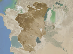 Map of the Ustyurt Plateau | |
| Coordinates: 43°17′N 55°33′E / 43.283°N 55.550°E | |
| Location | Kazakhstan / Turkmenistan / Uzbekistan |
| Area | |
| • Total | 200,000 km2 (77,000 sq mi) |
| Elevation | 160 meters (520 ft) to 200 meters (660 ft) |
The Ustyurt or Ust-Yurt (from Kazakh: Үстірт; Uzbek: Ustyurt; Turkmen: Üstyurt; Karakalpak: Ústirt — flat hill, plateau) is a transboundary clay desert shared by Turkmenistan, Uzbekistan and Kazakhstan.[1]
The plateau's semi-nomadic population raises sheep, goats, and camels.
YouTube Encyclopedic
-
1/3Views:7 01116 1281 654
-
THIS IS KAZAKHSTAN - The Mind Blowing Ustyurt Plateau
-
Barsa Kelmes lake. Ustyurt plateau in Uzbekistan. Uzbekistan's tourist attractions.
-
Beliuli Caravanserai. Ustyurt Plateau. The history of Uzbekistan (Central Asia).
Transcription
Geography
The Ustyurt is located between the Dead Kultuk, Mangyshlak Peninsula and Kara-Bogaz-Gol of the Caspian Sea to the west, and the Aral Sea, Amudarya Delta and Sarygamysh Lake to the east.
It extends roughly 200,000 km2 (77,000 sq mi), with an average altitude of 150 m (490 ft). Its highest point rises to 370 m (1,200 ft) in the south-west.[2] At its northeastern edge it drops steeply to the Aral Sea and the surrounding plain.
The Ustyurt Plateau is bounded by steep cliffs called chinks nearly from everywhere. To the east, it encompasses the historical western shoreline of the Aral Sea. In the southern region, it extends to the Kunya-Darya alluvial plain and the valley of the Uzboy, while in the west, it reaches the Karynyaryk depression. To the north, it spans the Karakum sands of the North Caspian Sea and includes the Caspian Depression. [3] Ustyurt chinks often have multicolored layers, with colors of pale pink, blue, clear white, etc., and can form fancy landscapes.[4]
Protected areas
Kazakhstan created the Ustyurt Nature Reserve (223,300 hectares) in July, 1984 in the south of Mangystausky district in Eralievsky region.[5] It preserves rare fauna and flora such as the Ustyurt Mountain sheep and the Saiga antelope.[6] Among its features are Sherkala Mountain and the concretions found in the Torysh ('Valley of Balls') near the town of Shetpe.
See also
References
- ^ Gritsina, M. (2019). "The Caracal Caracal caracal Schreber, 1776 (Mammalia: Carnivora: Felidae) in Uzbekistan". Journal of Threatened Taxa. 11 (4): 13470–13477. doi:10.11609/jott.4375.11.4.13470-13477.
- ^ "The Ustyurt Plateau" (PDF). USAID. Retrieved 15 August 2016.
- ^ ФАУНА НАЗЕМНЫХ ПОЗВОНОЧНЫХ ВОСТОЧНОГО ЧИНКА ПЛАТО УСТЮРТ
- ^ Устюртский заповедник, Западный Казахстан
- ^ "Ustyurtsky state natural reserve". Welcome to Kazakhstan. Silk Tour agency. Archived from the original on 13 September 2016. Retrieved 16 August 2016.
- ^ "Ustyurt Nature Reserve, Kazakhstan". Advantour. Retrieved 16 August 2016.
External links
 Media related to Ustyurt at Wikimedia Commons
- Hundreds of desert kites in the Ustyurt. Nat. Geographic
This Uzbekistan location article is a stub. You can help Wikipedia by expanding it. |
This Kazakhstan location article is a stub. You can help Wikipedia by expanding it. |