
| Urubamba River Vilcanota River | |
|---|---|
 Urubamba River seen from train en route to Machu Picchu | |
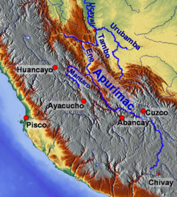 Map of larger rivers in south-central Peru | |
| Location | |
| Country | Peru |
| Physical characteristics | |
| Mouth | Ucayali River |
• coordinates | 10°42′07″S 73°45′15″W / 10.70194°S 73.75417°W |
| Length | 724 km (450 mi)[1] |
| Basin features | |
| Tributaries | |
| • left | Lucumayo, Cusichaca, Kachimayu |
| • right | Chillcamayu, Yavero |

The Urubamba River or Vilcamayo River[2] (possibly from Quechua Willkamayu, for "sacred river")[3] is a river in Peru. Upstream it is called Vilcanota River (possibly from Aymara Willkanuta, for "house of the sun").[4] Within the La Convención Province, the name changes to Urubamba.[5] A partially navigable headwater of the Amazon River, the Urubamba rises in the Andes to the southeast of Cusco. It originates on the slopes of Cunurana in the Puno Region, Melgar Province, near the La Raya pass.[5] It flows north-north-west for 724 km (450 mi) before coalescing with the Tambo River to form the Ucayali River.
The Urubamba is divided into the Upper Urubamba and the Lower Urubamba, the dividing feature being the Pongo de Mainique, an infamous whitewater canyon.
YouTube Encyclopedic
-
1/3Views:9066751 086
-
Original Name Of Urubamba River, Peru
-
The raging Urubamba River
-
MACHU PICCHU | URUBAMBA RIVER | SACRED VALLEY | ADVENTURES BY DISNEY PERU!
Transcription
Upper Urubamba
The Upper Urubamba (Alto Urubamba) valley features a high population and extensive irrigation works. A number of ruins of the Inca Empire lie in the Sacred Valley, including the Incan city of Machu Picchu, Patallaqta, Pikillaqta and Raqch'i. The Salcca-Pucara hydroelectric project is associated with the river as well.[6]
Lower Urubamba
The Lower Urubamba (Bajo Urubamba) is relatively undeveloped and features a significant indigenous population consisting of the Campa tribes, principally the Machiguenga (Matsigenka) and Asháninka. The economy is based on forestry and the nearby Camisea Gas Project. The main settlement in the region is the town of Sepahua. (Sepahua River coordinates are 11°08′58″S 73°02′55″W / 11.14944°S 73.04861°W.)
1934 first mapping
The lower Urubamba River was mapped for the first time in 1934 by Edward Kellog Strong III. He and two friends from Palo Alto, California, Art Post and Gain Allan John, navigated the river with its ferocious rapids by canoe and balsa rafts provided by the indigenous people. The mapping was done at the request of the Peruvian military when they heard of the expedition planned by the three 18-year-olds.
It was turned over to the military when the boys arrived in Iquitos. It was the only map of the river until it was mapped by satellite many years later. The names and places on the latest map came from the original map drawn by Edward Strong.
John Walter Gregory, a British geologist, drowned in the river on June 2, 1932 while on a geological expedition to the Andes.
Tributaries
- Yukay
- Pampacchuana
- Aobamba
- Ste. Teresa or Salcantay
- Sacsara
- Lucumayo
- Vilcabamba
- Chawpimayu
- Pampaconas
- San Miguel
- Comportayoc
- Concevidayoc
- Cosireni
See also
References
- ^ Ziesler, R.; Ardizzone, G.D. (1979). "Amazon River System". The Inland waters of Latin America. Food and Agriculture Organization of the United Nations. ISBN 92-5-000780-9. Archived from the original on 8 November 2014.
- ^ "MINISTERIO DE TRABAJO DESTINARA S/.5.6 MILLONES PARA LA CAPACITACION DE JOVENES EN LA REGION CUSCO". Ministerio de Trabajo y Promoción del Empleo. Retrieved June 7, 2014.
- ^ "Diccionario: Quechua - Español - Quechua, Simi Taqe: Qheswa - Español - Qheswa" (PDF). Diccionario Quechua - Español - Quechua. Gobierno Regional del Cusco, Perú: Academía Mayor de la Lengua Quechua. 2005.
- Willkamayu - s. Geog. (Río Sagrado) Vilcanota
- ^ Radio San Gabriel, "Instituto Radiofonico de Promoción Aymara" (IRPA) 1993, Republicado por Instituto de las Lenguas y Literaturas Andinas-Amazónicas (ILLLA-A) 2011, Transcripción del Vocabulario de la Lengua Aymara, P. Ludovico Bertonio 1612 (Spanish-Aymara-Aymara-Spanish dictionary)
- Willkanuta - Adoratorio muy célebre entre Sicuana y Chungara. Significa casa del Sol, según los indios bárbaros. Willka - Adoratorio dedicado al Sol u otros ídolos. / El Sol como antiguamente decían y ahora dicen inti. Uta - Nombre. Casa cubierta.
- ^ a b Ministerio del Ambiente, Estudio linea base ambiental de la cuenca del río Vilcanota, Lima-Peru, 2010 (in Spanish)
- ^ Salcedo, José Víctor (9 December 2011). "Persiste el rechazo a la hidroeléctrica Salcca Pucara en las comunidades campesinas de Canchis". La República (in Spanish). Cusco. Retrieved 27 November 2018.
External links
 Media related to Urubamba River at Wikimedia Commons
| International | |
|---|---|
| National | |