
Unterspreewald | |
|---|---|
Location of Unterspreewald within Dahme-Spreewald district 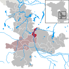 | |
 Unterspreewald  Unterspreewald | |
| Coordinates: 52°05′00″N 13°52′00″E / 52.08333°N 13.86667°E | |
| Country | Germany |
| State | Brandenburg |
| District | Dahme-Spreewald |
| Municipal assoc. | Unterspreewald |
| Subdivisions | 3 Ortsteile |
| Government | |
| • Mayor (2019–24) | Daniel Neumann[1] |
| Area | |
| • Total | 25.8 km2 (10.0 sq mi) |
| Elevation | 72 m (236 ft) |
| Population (2022-12-31)[2] | |
| • Total | 780 |
| • Density | 30/km2 (78/sq mi) |
| Time zone | UTC+01:00 (CET) |
| • Summer (DST) | UTC+02:00 (CEST) |
| Postal codes | 15910 |
| Dialling codes | 035473 |
| Vehicle registration | LDS |
| Website | www.unterspreewald.de |
Unterspreewald is a municipality in the district of Dahme-Spreewald in Brandenburg in Germany.
YouTube Encyclopedic
-
1/3Views:1 0756661 173
-
Schlepzig im Spreewald
-
Spreewald-Kahnfahrt - Alter Bauernhafen
-
SPREEWALD - Brandenburg "Urlaub im Naturparadies Spreewald" Teil 3 - DEUTSCHLAND
Transcription
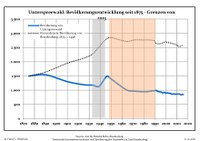
Demography
|
|
|
References
- ^ Landkreis Dahme-Spreewald Wahl der Bürgermeisterin / des Bürgermeisters, accessed 30 June 2021.
- ^ "Bevölkerungsentwicklung und Bevölkerungsstandim Land Brandenburg Dezember 2022" (PDF). Amt für Statistik Berlin-Brandenburg (in German). June 2023.
- ^ Detailed data sources are to be found in the Wikimedia Commons.Population Projection Brandenburg at Wikimedia Commons

| International | |
|---|---|
| National | |
This Brandenburg location article is a stub. You can help Wikipedia by expanding it. |