
Ulundi
oLundi | |
|---|---|
 Ulundi  Ulundi | |
| Coordinates: 28°19′S 31°25′E / 28.317°S 31.417°E | |
| Country | South Africa |
| Province | KwaZulu-Natal |
| District | Zululand |
| Municipality | Ulundi |
| Area | |
| • Total | 16.62 km2 (6.42 sq mi) |
| Elevation | 540 m (1,770 ft) |
| Population (2011)[1] | |
| • Total | 19,840 |
| • Density | 1,200/km2 (3,100/sq mi) |
| Racial makeup (2011) | |
| • Black African | 98.9% |
| • Coloured | 0.3% |
| • Indian/Asian | 0.2% |
| • White | 0.2% |
| • Other | 0.4% |
| First languages (2011) | |
| • Zulu | 93.4% |
| • English | 2.6% |
| • S. Ndebele | 1.1% |
| • Other | 2.9% |
| Time zone | UTC+2 (SAST) |
| PO box | 3838 |
| Area code | 035 |
Ulundi, also known as Mahlabathini, is a town in the Zululand District Municipality. At one time the capital of the Zulu Kingdom[2] in South Africa and later the capital of the Bantustan of KwaZulu, Ulundi now lies in KwaZulu-Natal Province (of which, from 1994 to 2004, it alternated with Pietermaritzburg as the provincial capital). The town now includes Ulundi Airport, a three-star hotel, and some museums amongst its sights. In the 2001 Census, the population of the town was recorded as 18,420.[3]
History
When Cetshwayo became king of the Zulus on 1 September 1873, he created, as was customary, a new capital for the nation, naming it "Ulundi" ("The high place"). On 4 July 1879, in the Battle of Ulundi (the final battle of the Anglo-Zulu War), the British Army captured the royal kraal and razed it to the ground.
Nearby is Ondini, where King Mpande, Cetshwayo's father, had his kraal. A large Zulu hut now is on the site.
Climate
Köppen-Geiger climate classification system classifies its climate as humid subtropical (Cfa).[4] It is rainier in the warmer months.
| Climate data for Ulundi | |||||||||||||
|---|---|---|---|---|---|---|---|---|---|---|---|---|---|
| Month | Jan | Feb | Mar | Apr | May | Jun | Jul | Aug | Sep | Oct | Nov | Dec | Year |
| Mean daily maximum °C (°F) | 28.2 (82.8) |
28.3 (82.9) |
27.3 (81.1) |
25.9 (78.6) |
24.3 (75.7) |
22.4 (72.3) |
22.5 (72.5) |
23.8 (74.8) |
25.0 (77.0) |
25.7 (78.3) |
26.3 (79.3) |
27.6 (81.7) |
25.6 (78.1) |
| Daily mean °C (°F) | 22.9 (73.2) |
23.1 (73.6) |
22.1 (71.8) |
20.3 (68.5) |
18.2 (64.8) |
16.0 (60.8) |
16.1 (61.0) |
17.2 (63.0) |
18.8 (65.8) |
19.9 (67.8) |
20.9 (69.6) |
22.1 (71.8) |
19.8 (67.6) |
| Mean daily minimum °C (°F) | 17.6 (63.7) |
17.9 (64.2) |
16.9 (62.4) |
14.8 (58.6) |
12.2 (54.0) |
9.7 (49.5) |
9.7 (49.5) |
10.7 (51.3) |
12.6 (54.7) |
14.1 (57.4) |
15.6 (60.1) |
16.7 (62.1) |
14.0 (57.3) |
| Average precipitation mm (inches) | 123 (4.8) |
109 (4.3) |
90 (3.5) |
49 (1.9) |
28 (1.1) |
18 (0.7) |
18 (0.7) |
30 (1.2) |
56 (2.2) |
98 (3.9) |
110 (4.3) |
115 (4.5) |
844 (33.1) |
| Source: Climate-Data.org (altitude: 535m)[4] | |||||||||||||
References
- ^ a b c d "Main Place Ulundi". Census 2011.
- ^ Lyde, Lionel William (1907). "South Africa". A Geography of Africa. Adam and Charles Black. p. 97.
- ^ "Main Place 'Ulundi Part 1'". Census 2001. Retrieved 3 June 2011.
- ^ a b "Climate: Ulundi – Climate graph, Temperature graph, Climate table". Climate-Data.org. Retrieved 10 December 2013.
External links
- Battles around Ulundi
- Chisholm, Hugh, ed. (1911). . Encyclopædia Britannica (11th ed.). Cambridge University Press.
Municipalities and communities of Zululand District Municipality, KwaZulu-Natal | ||
|---|---|---|
District seat: Ulundi | ||
| Ulundi | 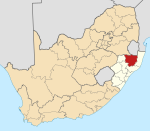 | |
| Nongoma | ||
| Abaqulusi | ||
| uPhongolo | ||
| EDumbe | ||
| International | |
|---|---|
| National | |
This KwaZulu-Natal location article is a stub. You can help Wikipedia by expanding it. |