
uMfolozi
Mbonambi | |
|---|---|
 Seal | |
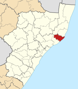 Location in KwaZulu-Natal | |
| Country | South Africa |
| Province | KwaZulu-Natal |
| District | King Cetshwayo |
| Seat | KwaMbonambi |
| Wards | 15 |
| Government | |
| • Type | Municipal council |
| • Mayor | Cllr Xolani Bhengu[1] |
| Area | |
| • Total | 1,210 km2 (470 sq mi) |
| Population (2011)[3] | |
| • Total | 122,889 |
| • Density | 100/km2 (260/sq mi) |
| Racial makeup (2011) | |
| • Black African | 98.8% |
| • Coloured | 0.2% |
| • Indian/Asian | 0.2% |
| • White | 0.8% |
| First languages (2011) | |
| • Zulu | 92.6% |
| • English | 2.9% |
| • Southern Ndebele | 1.5% |
| • Other | 3% |
| Time zone | UTC+2 (SAST) |
| Municipal code | KZN281 |
uMfolozi Local Municipality (formerly Mbonambi Local Municipality) is a local municipality within the King Cetshwayo District Municipality of KwaZulu-Natal in South Africa. It is situated around the town of KwaMbonambi, to the north of Richard's Bay, stretching from the Indian Ocean to the edge of the Hluhluwe–Imfolozi Park.
It was originally named Mbonambi Local Municipality, renamed to Mfolozi Local Municipality on 21 May 2009,[5] and renamed again to uMfolozi Local Municipality on 12 February 2015.[6] The name "Mbonambi" refers to the Mbonambi Local Tribal Authority, which covers most of the municipal area.[7] The name Mfolozi/uMfolozi refers to the Umfolozi River which forms the northern boundary of the municipality.
The municipality was enlarged at the time of the South African municipal election, 2016 when part of the disbanded Ntambanana Local Municipality was merged into it.[8]
YouTube Encyclopedic
-
1/3Views:3 46013 9161 382
-
Ghost Mountain Inn | Mkuze, South Africa | Mkhuze, Hluhluwe, Jozini
-
Jozini Tiger Lodge - Accommodation Lake Jozini South Africa - Africa Travel Channel
-
Cango Caves Oudtshoorn, South Africa Tourism, Mobile Version
Transcription
Main places
The 2001 census divided the municipality into the following main places:[9]
| Place | Code | Area (km2) | Population |
|---|---|---|---|
| Kwambonambi Forest Reserve | 53702 | 62.25 | 222 |
| KwaMbonambi | 53701 | 2.35 | 1,894 |
| Mapelane Nature Reserve | 53703 | 52.78 | 54 |
| Mbonambi | 53704 | 86.04 | 22,984 |
| Mhlana | 53705 | 515.65 | 64,527 |
| Sokhulu | 53706 | 98.17 | 12,632 |
| Remainder of the municipality | 53707 | 391.24 | 4,623 |
Politics
The municipal council consists of thirty-five members elected by mixed-member proportional representation. Eighteen councillors are elected by first-past-the-post voting in eighteen wards, while the remaining seventeen are chosen from party lists so that the total number of party representatives is proportional to the number of votes received.
In the election of 1 November 2021 the Inkatha Freedom Party (IFP) won a narrow majority of eighteen seats on the council. The following table shows the results of the 2021 election.[10]
| Party | Ward | List | Total seats | |||||
|---|---|---|---|---|---|---|---|---|
| Votes | % | Seats | Votes | % | Seats | |||
| Inkatha Freedom Party | 18,884 | 48.83 | 14 | 19,572 | 50.57 | 4 | 18 | |
| African National Congress | 14,622 | 37.81 | 4 | 14,230 | 36.77 | 9 | 13 | |
| Economic Freedom Fighters | 3,223 | 8.33 | 0 | 3,359 | 8.68 | 3 | 3 | |
| Independent candidates | 632 | 1.63 | 0 | 0 | ||||
| National Freedom Party | 292 | 0.76 | 0 | 304 | 0.79 | 1 | 1 | |
| Democratic Alliance | 303 | 0.78 | 0 | 272 | 0.70 | 0 | 0 | |
| African Independent Congress | 145 | 0.37 | 0 | 375 | 0.97 | 0 | 0 | |
| Abantu Batho Congress | 170 | 0.44 | 0 | 161 | 0.42 | 0 | 0 | |
| African People's Movement | 109 | 0.28 | 0 | 125 | 0.32 | 0 | 0 | |
| African Christian Democratic Party | 100 | 0.26 | 0 | 93 | 0.24 | 0 | 0 | |
| South Africa Vuka Movement | 87 | 0.22 | 0 | 69 | 0.18 | 0 | 0 | |
| African Mantungwa Community | 53 | 0.14 | 0 | 53 | 0.14 | 0 | 0 | |
| African Transformation Movement | 23 | 0.06 | 0 | 53 | 0.14 | 0 | 0 | |
| United Christian Democratic Party | 31 | 0.08 | 0 | 34 | 0.09 | 0 | 0 | |
| Total | 38,674 | 100.00 | 18 | 38,700 | 100.00 | 17 | 35 | |
| Valid votes | 38,674 | 98.35 | 38,700 | 98.35 | ||||
| Invalid/blank votes | 647 | 1.65 | 648 | 1.65 | ||||
| Total votes | 39,321 | 100.00 | 39,348 | 100.00 | ||||
| Registered voters/turnout | 74,081 | 53.08 | 74,081 | 53.11 | ||||
By-elections from November 2021
The following by-elections were held to fill vacant ward seats in the period from the election in November 2021.
| Date | Ward | Party of the previous councillor | Party of the newly elected councillor | ||
|---|---|---|---|---|---|
| 3 August 2022[11] | 52801003 | Inkatha Freedom Party | Inkatha Freedom Party | ||
References
- ^ [1] Office of the Mayor
- ^ "Contact list: Executive Mayors". Government Communication & Information System. Archived from the original on 14 July 2010. Retrieved 22 February 2012.
- ^ a b "Statistics by place". Statistics South Africa. Retrieved 27 September 2015.
- ^ "Statistics by place". Statistics South Africa. Retrieved 27 September 2015.
- ^ Department of Local Government and Traditional Affairs (21 May 2009). "Notice in terms of section 16(1)(b) of the Local Government: Municipal Structures Act, 1998 – Mbonambi Municipality". Provincial Gazette of KwaZulu-Natal. Vol. 3, no. 275. Pietermaritzburg: Government Printer.
- ^ Department of Co-operative Governance and Traditional Affairs (12 February 2015). "Notice in terms of section 16(3)(c) of the Local Government: Municipal Structures Act, 1998 – proposed name change of the Mfolozi Municipality" (PDF). Provincial Gazette of KwaZulu-Natal. Vol. 9, no. 1309. Pietermaritzburg: Government Printer. Retrieved 2021-05-10.
- ^ South African Languages - Place names
- ^ "Ntambanana municipality to dissolve in September". Zululand Observer. 22 April 2016.
- ^ Lookup Tables - Statistics South Africa[permanent dead link]
- ^ "Election Result Table for LGE2021 — Mfolozi". wikitable.frith.dev. Retrieved 2021-11-28.
- ^ "Municipal By-elections results - Electoral Commission of South Africa". results.elections.org.za. Retrieved 2022-08-04.
External links
| Metropolitan |  | ||||||||||||||||||||
|---|---|---|---|---|---|---|---|---|---|---|---|---|---|---|---|---|---|---|---|---|---|
| District and local |
| ||||||||||||||||||||
28°48′S 32°06′E / 28.800°S 32.100°E