
 Vanessa after peak intensity on October 28 | |
| Meteorological history | |
|---|---|
| Formed | October 22, 1984 |
| Extratropical | October 30, 1984 |
| Dissipated | October 30, 1984 |
| Violent typhoon | |
| 10-minute sustained (JMA) | |
| Highest winds | 220 km/h (140 mph) |
| Lowest pressure | 880 hPa (mbar); 25.99 inHg |
| Category 5-equivalent tropical cyclone | |
| 1-minute sustained (SSHWS/JTWC) | |
| Highest winds | 285 km/h (180 mph) |
| Overall effects | |
| Fatalities | 63 total |
| Damage | $1.7 million |
| Areas affected | |
Part of the 1984 Pacific typhoon season | |
Typhoon Vanessa, known in the Philippines as Typhoon Toyang, was the strongest tropical cyclone of the 1984 Pacific typhoon season and one of the most intense tropical cyclones on record. It was the twenty-second named storm, twelfth typhoon, and first super typhoon of the 1984 season.
YouTube Encyclopedic
-
1/3Views:2 3362 5004 614
-
1991 Pacific typhoon season
-
The 1984 typhoon season in the western North Pacific
-
Unforgettable typhoons in the Philippines 90's
Transcription
Meteorological history
Tropical storm (39–73 mph, 63–118 km/h)
Category 1 (74–95 mph, 119–153 km/h)
Category 2 (96–110 mph, 154–177 km/h)
Category 3 (111–129 mph, 178–208 km/h)
Category 4 (130–156 mph, 209–251 km/h)
Category 5 (≥157 mph, ≥252 km/h)
Unknown
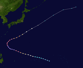
A low pressure area developed from a near equatorial trough southeast of Ponape on October 20, moving northwest until being well north of the island as it slowly developed. The disturbance strengthened into a tropical depression on October 22 and a tropical storm October 23. The next day, Vanessa strengthened into a minimal typhoon.[1]
Moving west-northwest, Vanessa began to explosively intensify on October 25, becoming a super typhoon two days later. Super Typhoon Vanessa continued to intensify throughout the day, reaching its peak intensity with maximum sustained wind speeds of 180 miles per hour (290 km/h) well west of the Philippines. At its peak, it had a pressure of 880 mb, which makes it tied as the seventh most intense tropical cyclone on record, behind Ida of 1958 and only 10 millibars higher than the record-setting Typhoon Tip of 1979. Vanessa's central pressure had fallen at a near-record pace of 100 mb in 48 hours. The intense cyclone recurved to the northeast on October 27 and 28 as a cold front approached from the northwest. Vanessa slowly weakened and began to merge with the frontal boundary, becoming a storm-force extratropical cyclone late on October 30 before being absorbed by the front later that day.[1]
Impact
| Typhoon | Season | Pressure | ||
|---|---|---|---|---|
| hPa | inHg | |||
| 1 | Tip | 1979 | 870 | 25.7 |
| 2 | June | 1975 | 875 | 25.8 |
| Nora | 1973 | |||
| 4 | Forrest | 1983 | 876[2] | 25.9 |
| 5 | Ida | 1958 | 877 | 25.9 |
| 6 | Rita | 1978 | 878 | 26.0 |
| 7 | Kit | 1966 | 880 | 26.0 |
| Vanessa | 1984 | |||
| 9 | Nancy | 1961 | 882 | 26.4 |
| 10 | Irma | 1971 | 884 | 26.1 |
| 11 | Nina | 1953 | 885 | 26.1 |
| Joan | 1959 | |||
| Megi | 2010 | |||
| Source: JMA Typhoon Best Track Analysis Information for the North Western Pacific Ocean.[3] | ||||
As a minimal typhoon, Vanessa moved about 165 kilometres (103 mi) south of Guam, where winds gusted to 59 knots (109 km/h) on Nimitz Hill. Damage on the island totaled US$1.7 million (1984 dollars, US$4.98 million in 2023), mainly to the banana crop.[1]
Though the storm did not directly impact the Philippines, its outer bands triggered flooding that killed 63 people.[4]
References
- ^ a b c Joint Typhoon Warning Center; Naval Pacific Meteorology and Oceanography Center (1987). Annual Tropical Cyclone Report: 1984 (PDF) (Report). United States Navy, United States Air Force. Retrieved May 19, 2017.
- ^ "World Tropical Cyclone Records". World Meteorological Organization. Arizona State University. Retrieved December 12, 2013.
- ^ Japan Meteorological Agency. "RSMC Best Track Data (Text)" (TXT).
- ^ "Destructive Typhoons 1970–2003". National Disaster Coordinating Council. November 9, 2004. Archived from the original on November 9, 2004. Retrieved April 22, 2013.