
 Tureia | |
 Tureia | |
| Geography | |
|---|---|
| Location | Pacific Ocean |
| Coordinates | 20°46′16″S 138°33′53″W / 20.77111°S 138.56472°W |
| Archipelago | Tuamotus |
| Area | 47 km2 (18 sq mi) (lagoon) 8 km2 (3 sq mi) (above water) |
| Length | 15 km (9.3 mi) |
| Width | 8 km (5 mi) |
| Administration | |
France | |
| Overseas collectivity | French Polynesia |
| Administrative subdivision | Tuamotus |
| Commune | Tureia |
| Largest settlement | Hakamaru |
| Demographics | |
| Population | 275[1] (2017) |
Tureia | |
|---|---|
 NASA image of Tureia Atoll. | |
 | |
Location of Tureia  | |
| Coordinates: 20°46′16″S 138°33′53″W / 20.771228°S 138.564828°W | |
| Country | France |
| Overseas collectivity | French Polynesia |
| Subdivision | Îles Tuamotu-Gambier |
| Area 1 | 8 km2 (3 sq mi) |
| Population (2017)[1] | 336 |
| • Density | 42/km2 (110/sq mi) |
| Time zone | UTC−10:00 |
| INSEE/Postal code | 98755 / |
| 1 French Land Register data, which excludes lakes, ponds, glaciers > 1 km2 (0.386 sq mi or 247 acres) and river estuaries. | |
Tureia (also called Papahena, Papakena, and Carysfort Island) is an atoll in the Tuamotu Archipelago in French Polynesia.
Tureia atoll is 15 km long and has a maximum width of 8 kilometres (5.0 miles); its total land area is 8 km2. A very long island covers completely its eastern reef. The lagoon has no navigable entrance.
The village of Hakamaru (or Fakamaru) is the only settlement on Tureia, at the northern tip of the atoll. Almost all of the arable land on Tureia is dedicated to growing coconuts. The population in this atoll has risen to 275 in 2017;[1] in 1977 there were only 121 inhabitants.
YouTube Encyclopedic
-
1/2Views:2 4532 682
-
Alberto_71_Hao_Tureia.mpg
-
Alberto_Tureia_Hao_1971
Transcription
History
The first recorded European to arrive at Tureia was Captain Edward Edwards in 1791, during his search for the Bounty mutineers. Edwards called the atoll "Carysfort", after John Proby, 1st Earl of Carysfort.
From 1966 to 1999, Tureia hosted an outpost of the Centre d'Expérimentation du Pacifique, the French authority supervising nuclear tests on the nearby atolls of Moruroa and Fangataufa, which lie about 115 km south of Tureia. There was also a weather station on Tureia during those years. Currently, both installations have been abandoned.
This atoll has a 900 m-long airstrip (IATA: ZTA, ICAO: NTGY). Tureia Airport was inaugurated in 1985.

Administration
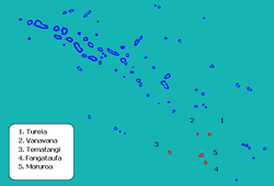
Administratively Tureia Atoll is part of the commune of Tureia, which also includes the atolls of Fangataufa, Moruroa, Tematangi and Vanavana.[2]
References
- ^ a b c "Répartition de la population en Polynésie française en 2017" [Distribution of the population in French Polynesia in 2017] (PDF). Institut de la statistique de la Polynésie française (in French). 14 December 2017. Archived from the original (PDF) on 24 October 2018. Retrieved 16 November 2023.
- ^ Décret n°72-407 du 17 mai 1972 portant création de communes dans le territoire de la Polynésie française, Légifrance
External links
- Tureia at OceanDots.com at the Wayback Machine (archived December 23, 2010)
- Tureia Airport
- Atoll list (in French)
- Pictures of Tureia (in French)
Tuamotus Gambiers | Islands/Atolls | ||
|---|---|---|---|
| Island groups | |||
This French Polynesia-related geography article is a stub. You can help Wikipedia by expanding it. |