
 The Traversay Islands within the South Sandwich Islands | |
 Location of the South Sandwich Islands | |
| Geography | |
|---|---|
| Coordinates | 56°36′S 027°43′W / 56.600°S 27.717°W |
| Archipelago | South Sandwich Islands |
| Administration | |
United Kingdom | |
| Demographics | |
| Population | Uninhabited |
The Traversay Islands (Spanish: Archipiélago Marqués de Traverse) are a group of three islands—Zavodovski, Leskov and Visokoi—at the northern end of the South Sandwich Islands.[1][2]
History
The group was discovered in November 1819 by a Russian expedition under Bellingshausen,[1][3] who named them for Jean-Baptiste Prevost de Sansac, Marquis de Traversay (1754–1831), a French naval officer who joined the Russian navy in 1791, at the request of an émigré Frenchman in Russian service, admiral Nassau-Siegen.[4] He was Minister of Naval Affairs at Saint Petersburg, 1809–28, and chief promoter of Bellingshausen's Antarctic voyage. The name was previously transliterated as Traverse because it was incorrectly thought that the man commemorated was a Russian.
Geography
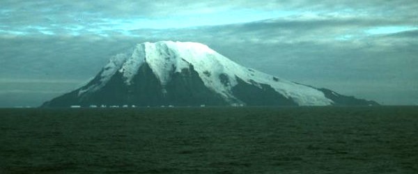
Zavodovski Island (56°18′S 27°34′W / 56.300°S 27.567°W) lies 350 kilometres (217 mi) southeast of South Georgia Island. It is the northernmost of the South Sandwich Islands and the nearest to South Georgia. The island is approximately 5 kilometres (3.1 miles) across with a peak elevation of 551 metres (1,808 feet) above sea level.[4] The stratovolcano Mount Asphyxia dominates the western side of the island while the eastern half is a low-lying lava plain.
Mount Asphyxia is believed to be active with fresh lava reported in 1830 and numerous indications of activity since.[5] Approximately 50% of the island is composed of tephra. The island is home to around two million breeding chinstrap penguins,[6] making it one of the world's largest penguin colonies.[7] Zavodovski Island featured in the initial part of BBC’s Planet Earth II natural history television series, narrated by David Attenborough and first shown in the UK on 6 November 2016. The programme described in film life in the harsh environment for the 1.5 million Chinstrap penguins – the largest penguin colony in the world.
Visokoi Island (56°42′S 27°12′W / 56.700°S 27.200°W), which lies to the southeast of Zavodovski, is 7.2 km (4.5 miles) long and 4.8 km (3 miles) wide, capped by Mount Hodson, a volcanic peak (1,005 m or 3,297 ft).[4] The peak is named after Sir Arnold Weinholt Hodson, a governor of the Falkland Islands. Visokoi means "high".[8] The island's eastern tip, Point Irving, is named for the leader of a British exploratory and mapping expedition, Commander John J. Irving; the father of British writer and Holocaust denier, David Irving.
Leskov Island (56°40′S 28°10′W / 56.667°S 28.167°W) is located to the west of the main arc of the South Sandwich Islands and is less than 1.5 kilometres (0.9 mi) long, and lies 48 km (30 mi) west of Visokoi.[4] It was named by Bellingshausen after the third lieutenant on the expedition ship Vostok. It is composed of andesitic rather than basaltic lava.[9] The subduction zone forming the South Sandwich Trench lies to the east of the island arc.
See also
References
- ^ a b Stonehouse, Bernard (2002). Encyclopedia of Antarctica and the southern oceans. John Wiley and Sons. p. 244. ISBN 978-0-471-98665-2. Retrieved 6 January 2012.
- ^ Scientific reports. British Antarctic Survey. 1962. Retrieved 6 January 2012.
- ^ Paine, Lincoln P. (15 November 2000). Ships of discovery and exploration. Houghton Mifflin Harcourt. p. 152. ISBN 978-0-395-98415-4. Retrieved 6 January 2012.
- ^ a b c d LeMasurier, W. E.; Thomson, J. W., eds. (1990). Volcanoes of the Antarctic Plate and Southern Oceans. American Geophysical Union. p. 512 pp. ISBN 0-87590-172-7.
- ^ G. A. French (1974). The Antarctic pilot: comprising the coasts of Antarctica and all islands southward of the usual route of vessels. Hydrographer of the Navy. p. 146. Retrieved 6 January 2012.
- ^ Encyclopedia Of The Aquatic World. Marshall Cavendish. January 2004. p. 177. ISBN 978-0-7614-7418-0. Retrieved 6 January 2012.
- ^ Laboratoire de cryptogamie (Muséum national d'histoire naturelle) (2004). Cryptogamie: Algologie. Laboratoire de cryptogamie, Muséum national d'histoire naturelle. p. 262. Retrieved 6 January 2012.
- ^ Mills, William James (2003). Exploring polar frontiers: a historical encyclopedia. A — L. ABC-CLIO. p. 680. ISBN 978-1-57607-422-0. Retrieved 6 January 2012.
- ^ Transactions of the Caribbean Geological Conference. Queens College Press. 1968. p. 165. Retrieved 6 January 2012.
External links
- Photograph of Zavodovski Island
- Aerial photograph of Zavodovski Island This image belongs to John Smellie, Leicester University
- Photograph of Visokoi Island
56°36′S 27°43′W / 56.600°S 27.717°W
Capital: King Edward Point | |||||||
| General | |||||||
| Settlements / Whaling stations | |||||||
| South Georgia islands | |||||||
| South Sandwich Islands |
| ||||||
| Seamounts | |||||||
| Landmarks |
| ||||||