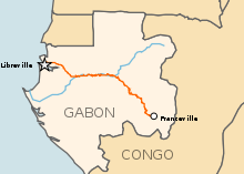
Modes of transport in Gabon include rail, road, water, and air. The one rail link, the Trans-Gabon Railway, connects the port of Owendo with the inland town of Franceville. While most of the country is connected by roads, not all areas are accessible. Much of the road network remains unpaved, and it primarily revolves around seven "national routes" labeled N1 through N7. The largest seaports are Port-Gentil and the newer Owendo, and 1,600 km of inland waterways are navigable. There are three international airports, eight other paved airports, and over 40 with unpaved runways. Nearly 300 km of pipelines carry petroleum products, mainly crude oil.
YouTube Encyclopedic
-
1/5Views:5508 0455062 0115 533
-
Trans-Cameroon Railway - Cameroon (1987)
-
Video MetroLib
-
Toy Railroad
-
Bolloré Logistics in Gabon - Logistics Oil & Gas Shore Base
-
Lastourville et le train
Transcription
Rail transport
Until the 1970s, Gabon had no permanent railroads, though temporary Decauville rail tracks were in use in the logging industry as early as 1913 (Gray and Ngolet, 1999, pp.102).[1]
In 2003, the railway began the process of installing a satellite based telecommunications system.[2] As of 2004, Gabon State Railways totalled 814 km of standard-gauge track.
total: 814 km (Gabon State Railways or OCTRA)
standard gauge: 814 km 1.435-m gauge; single track (1994)
Maps
- UN Map - shows line to Franceville
- UNHCR map - does not show line to Franceville
- TravelPortal map - shows major rivers
- UNJLC Rail map of Southern Africa - does not show line to Franceville
Cities served by rail
- Existing
- Libreville - capital
- Owendo - port
- Sahoué - port
- Franceville - railhead
- Ndjolé
- Lopé
- Booué - likely junction for branchline to Makokou
- Lastoursville
- Moanda
- Ntoum - proposed junction for iron ore traffic to Santa Clara
- Kango
- Four-Place
- Mounana - ?
- Proposed
- Makokou - iron ore
- Cape Santa Clara - proposed deep water port for Makokou iron ore.
- Bélinga - possible iron ore mine.
2006
- China signs a deal for an iron ore mine with associated rail and port upgrades from Belinga to Santa Clara [1]
2007
- New rail line from Belinga will go 450 km all the way to the coast, rather than to be a branch off an existing line.[3]
- Pan-African issues[4]
Road transport
total:
7,670 km
paved:
629 km (including 30 km of expressways)
unpaved:
7,041 km (1996 est.)
Roads in Gabon link most areas of the country, and many of the main roads are of a reasonable standard. However, remoter areas along the coast and in the east are often not connected to the road network. Major roads are denoted national routes and numbered, with a prefix "N" (sometimes "RN"):
- N1 road: Libreville – Kougouleu – Bifoun – Lambaréné – Mouila – Ndendé – Tchibanga - (Republic of Congo)
- N2 road: Bifoun – Alembe – Viate – Mitzic – Bibasse – Oyem – Bitam – Éboro – (Cameroon)
- N3 road: Alembe – Kazamabika – Lastoursville – Moanda – Franceville
- N4 road: Viate – Ekonlong – Makokou – Mékambo
- N5 road: Kougouleu – Bibasse
- N6 road: Mayumba – Tchibanga – Ndendé – Lébamba - Koulamoutou – Lastoursville
- N7 road: Makokou – Bakwaka – Okondja – Lékori - Akiéni – Ngouoni – Franceville
Water transport
Merchant marine
As of 2002, there was one merchant marine vessel, with a gross tonnage of 2,419/3,205 tonnes deadweight (DWT).
Waterways
Gabon has 1,600 km of perennially navigable waterways, including 310 km on the Ogooué River.
Air transport
There are three international airports: Libreville, Port-Gentil, and Franceville.
Airports - with paved runways
total:
11
over 3,047 m:
1
2,438 to 3,047 m:
1
1,524 to 2,437 m:
8
914 to 1,523 m:
1 (1999 est.)
Airports - with unpaved runways
total:
45
1,524 to 2,437 m:
9
914 to 1,523 m:
16
under 914 m:
25 (1999 est.)
Pipelines
Crude oil 270 km; petroleum products 14 km
See also
References
- ^ Gray, Christopher; Ngolet, François (1999). "Lambaréné, Okoumé and the Transformation of Labor along the Middle Ogooué (Gabon), 1870-1945". The Journal of African History. 40 (1): 87–107. doi:10.1017/S0021853798007361. JSTOR 183396.
- ^ "Railway telecom system 2003". Archived from the original on 2016-04-24. Retrieved 2006-07-17.
- ^ "Business Report - China given monopoly to work Gabon's untapped iron ore resources". Archived from the original on 2007-12-02. Retrieved 2008-01-01.
- ^ Railway Corridors in Africa to be Connected Archived 2011-07-17 at the Wayback Machine
![]() This article incorporates public domain material from The World Factbook. CIA.
This article incorporates public domain material from The World Factbook. CIA.
External links
Currency: CFA franc | |
| Communications |
|
| Industries |
|