
Tepelenë | |
|---|---|
 | |
 Emblem | |
 Tepelenë | |
| Coordinates: 40°17′48″N 20°01′08″E / 40.29667°N 20.01889°E | |
| Country | |
| County | Gjirokastër |
| Government | |
| • Mayor | Tërmet Peçi (PS) |
| Area | |
| • Municipality | 431.50 km2 (166.60 sq mi) |
| Population (2011) | |
| • Municipality | 8,949 |
| • Municipality density | 21/km2 (54/sq mi) |
| • Municipal unit | 4,342 |
| Time zone | UTC+1 (CET) |
| • Summer (DST) | UTC+2 (CEST) |
| Postal Code | 6301 |
| Area Code | (0)814 |
| Website | tepelena |
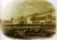
Tepelenë (Albanian definite form: Tepelena) is a city and a municipality in Gjirokastër County, in the south of Albania. The town is on the left bank of the Vjosa River,[1] about three kilometres downstream from its union with the Drino.
Until the abolition of Districts in 2000, Tepelenë was the seat of the Tepelenë District. Its location is strategically important and there is a ruined citadel occupying a point 300 metres above the river. Ali Pasha of Yanina was born at the nearby village of Beçisht, and Tepelena along with Ioannina were Ali's headquarters.[2] In 1847, the British writer Edward Lear visited the town and noted the devastated buildings.
Name
The name of Tepelene has been interpreted in three variants; the first connects the origin of this name with the Turkish word "Tepeleden" which means "head-piercing". The second version explains the word with "Tepe e Lenes" which means "the hill of Lenes" and the third more convincing version is the one which explains this name with the Illyrian word "Antibylyne" which means "in front of the Bylynes". Later this word evolves and takes the name Tepelene.[3]
History
The Byzantines built a defensive tower which was successively developed during the Ottoman Empire epoch in the 15th century and by Ali Pasha in the early 19th century.
In early July 1833 the inhabitants of Tepelenë rose in revolt against Emin Pasha.


The Young Turk revolutionaries met in Tepelenë in February 1909, in an attempt to persuade Albanian nationalists to join them.[4]
In 1920, an earthquake severely damaged the town which was completely rebuilt afterwards. Local tradition says that if Tepelenë exceeds 100 buildings it will be destroyed. In the same year, 400 Italian soldiers surrendered to the Albanians during the Battle of Vlora.
On 7 April 1939, Italian forces landed in Albania and took control of the country and Tepelenë in the beginning of World War II.[5] After the Italian invasion of Greece in October 1940 failed, the Albanian troops in Tepelenë under the command of Colonel Prenk Pervizi deserted the Italian army. The colonel protested by telling the Italian command that the Albanians were not cannon fodder.[6] As a consequence, Colonel Pervizi as well as other officers and Albanian troops were transferred into the mountains of northern Albania and isolated there.
Greek forces counter-attacked and advanced towards Tepelenë in a general offensive on Vlorë. Despite several attacks and assistance for the Greeks by the British Royal Air Force, the Italians managed to hold the town and in late April 1941, following the German invasion of Yugoslavia, the Greek army was forced to withdraw.[7]
Later, the post-war socialist government converted the local Italian army camp into a labour camp. Among those detained were influential Albanian families involved in the previous governments. Some died and their graves were unmarked.[8] The camp was closed in 1954. At one point a cholera epidemic killed many inmates.[9]
In the 1997 unrest in Albania, Tepelenë became a focal point for the uprising against Sali Berisha's government. A people's committee took charge of the town in March 1997 and released opposition politician Fatos Nano from the local prison. The movement spread immediately to Gjirokastër where weapons were distributed from Tepelenë.
Geography


Tepelenë is located on the left shore of the Vjosa River on a plateau above the river. The river applies here, after the river has broken through a few kilometres in the Këlcyrë Gorge a mountain chain, to the North. In addition the Drino flows at this point. North of Tepelenë, the Bënça river coming from the south-west from the Kurvelesh flows into the Vjosa.
Tepelenë was formed at the 2015 local government reform by the merger of the former municipalities Kurvelesh, Lopës, Qendër Tepelenë and Tepelenë, that became municipal units. The seat of the municipality is the town Tepelenë.[10]
Demographics
The total population of the city is 8,949 (2011 census),[11] in a total area of 431.50 km2.[12] The population of the former municipality at the 2011 census was 4,342 and completely ethnically Albanian.[11]
Economy

The local mineral water plant is an important and successful local enterprise.
Transport
Due to its location at the confluence of two valleys, Tepelena has always been an important traffic hub in southern Albania. The National Road 4 (SH4), from Fier to Gjirokastër, continues through Tepelenë.
Culture

Sports
The local football club is SK Tepelena.
Notable people

- Ali Pasha
- Foto Strakosha, soccer player Albania capped
- Muhedin Targaj, soccer player Albania capped
- Isuf Kalo, notable physician, personal doctor of Enver Hoxha
- Gramoz Ruçi, 37th Speaker of the Parliament of Albania
- Valentina Leskaj, former Minister of Work and Social Welfare
- Tafil Buzi, leader of the Albanian revolts of 1833–1839.
- Big Body Bes, rapper and TV presenter
- Toquel, rapper
- Stan Dragoti, American movie director with parents from Tepelena who migrated to America in the 1920s
See also
References
- ^ "Tepelene". travelsradiate: travelsradiate.com. Retrieved Jan 24, 2011.
- ^ Tanner 2014, p. 21: "That the word 'Albania' was known at all to the English-speaking public in the early nineteenth century was largely down to Byron, who passed through on his first expedition to Greece, aged 21. After reaching Patras in September 1809, he made a detour lasting several weeks to Ioannina, which now lies in Greece but was then considered the de facto capital of south-ern Albania, the honour normally being accorded to Shkodra in the north. He also visited Tepelena, which, alongside Ioannina, was the headquarters of the notorious warlord, Ali Pasha. He then returned to Patras and continued to Athens."
- ^ https://en.wiktionary.org/wiki/Tepelen%C3%AB
- ^ Pearson, Owen (2004). Albania in the Twentieth Century, A History: Volume I: Albania and King Zog, 1908-39. I. B. Tauris. pp. 5–8. ISBN 1845110137. Retrieved 31 July 2012.
- ^ Piero Crociani, "Gli albanesi nelle forze armate italiane, Roma 2001".
- ^ Pjeter Hidri, "The General Prenk Pervizi, Toena, Tirana, 2002.
- ^ Pearson, Owen (2006). Albania in Occupation and War: From Fascism to Communism 1940-1945. Bloomsbury Academic. pp. 102–143. ISBN 1-84511-104-4. Retrieved 19 March 2010.
- ^ Lek Pervizi, "Ankimi i Zanave, (poetry), Arberia, Tirana, 2002.
- ^ Gjuliana Malaj, "Une Beba, qe u futa ne camp kater muajshe e dola 42 vjeçe, Panorama, Tirana, 25 october 2012.
- ^ "Law nr. 115/2014" (PDF) (in Albanian). p. 6371. Retrieved 25 February 2022.
- ^ a b "Population and housing census - Gjirokastër 2011" (PDF). INSTAT. Retrieved 2019-09-25.
- ^ "Correspondence table LAU – NUTS 2016, EU-28 and EFTA / available Candidate Countries" (XLS). Eurostat. Retrieved 2019-09-25.
Bibliography
- Tanner, Marcus (2014). Albania's mountain queen: Edith Durham and the Balkans. London: I.B.Tauris. ISBN 9781780768199.
- Blue Guide to Albania and Kosovo from Zoitsa Vasi, James Pettifer, A&C Black, London, 2001
- Albania in the Twentieth Century, A History: Volume I: Albania and King Zog, 1908-39 , Owen Pearson,I. B. Tauris,2004
The municipalities of Albania are the country's administrative divisions consisting of local administrative units and their inclusive villages. | ||
| Berat County |  | |
| Dibër County | ||
| Durrës County | ||
| Elbasan County | ||
| Fier County | ||
| Gjirokastër County | ||
| Korçë County | ||
| Kukës County | ||
| Lezhë County | ||
| Shkodër County | ||
| Tiranë County | ||
| Vlorë County | ||
Subdivisions of Gjirokastër County | ||
|---|---|---|
County Seat: Gjirokastër | ||
| Municipality of Dropull |  | |
| Municipality of Gjirokastër | ||
| Municipality of Këlcyrë | ||
| Municipality of Libohovë | ||
| Municipality of Memaliaj | ||
| Municipality of Përmet | ||
| Municipality of Tepelenë | ||
Subdivisions of Tepelenë Municipality | ||
|---|---|---|
Municipal Seat: Tepelenë | ||
| Administrative Unit of Kurvelesh |
|  |
| Administrative Unit of Lopës |
| |
| Administrative Unit of Qendër Tepelenë | ||
| Administrative Unit of Tepelenë | ||
| International | |
|---|---|
| National | |