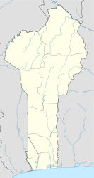
Tchaourou | |
|---|---|
| Coordinates: 8°53′N 2°36′E / 8.883°N 2.600°E | |
| Country | |
| Department | Borgou Department |
| Area | |
| • Total | 2,802 sq mi (7,256 km2) |
| Population (2013) | |
| • Total | 221,108 |
| Time zone | UTC+1 (WAT) |
Tchaourou [tʃa.u.ʁu] (Saworo in Yoruba etymology, meaning rattle[citation needed]) is a commune, arrondissement, and city located in the Borgou Department of Benin, a country in Western Africa, formerly known as Dahomey (until 1975). It is the birthplace of former Beninese president Yayi Boni.[citation needed] It is 50 kilometres (31 mi) south of Parakou.[1]
YouTube Encyclopedic
-
1/1Views:504
-
Ecotourisme au Bénin : Le Mont Souba Kpenou dans le Wari Maro (Tchaourou)
Transcription
Overview
The commune covers an area of 7,256 km2 (2,802 sq mi) and as of 2013 had a population of 221,108 people.,[2] while the Tchaourou city proper has a population of 106,852 people, making it the 10th largest settlement in Benin.[3]
Climate
| Climate data for Tchaourou | |||||||||||||
|---|---|---|---|---|---|---|---|---|---|---|---|---|---|
| Month | Jan | Feb | Mar | Apr | May | Jun | Jul | Aug | Sep | Oct | Nov | Dec | Year |
| Mean daily maximum °C (°F) | 34 (94) |
36 (96) |
36 (96) |
34 (94) |
33 (91) |
31 (88) |
28 (83) |
27 (81) |
29 (85) |
31 (87) |
33 (91) |
34 (93) |
32 (90) |
| Mean daily minimum °C (°F) | 19 (67) |
22 (71) |
23 (73) |
23 (73) |
22 (72) |
22 (71) |
21 (70) |
21 (69) |
21 (70) |
21 (69) |
21 (69) |
18 (64) |
21 (70) |
| Average precipitation mm (inches) | 7.6 (0.3) |
15 (0.6) |
58 (2.3) |
100 (4.1) |
140 (5.6) |
160 (6.3) |
170 (6.5) |
160 (6.4) |
210 (8.4) |
160 (6.3) |
15 (0.6) |
7.6 (0.3) |
1,210 (47.7) |
| Source: Weatherbase [4] | |||||||||||||
Demographics

The main languages of Tchaourou are Bariba, Fula (Fula: Fulfulde; French: Peul), Yoruba, Otamari and Yom Lokpa.
Administration
The commune is divided administratively into 7 arrondissements, in 5 quarters and 31 villages.
| Arrondissements | Quartiers & villages |
|---|---|
| Tchaourou | Tchalla, Oke Lagba |
| Alafiarou | |
| Bétérou | |
| Goro | |
| Kika | |
| Sanson | |
| Tchatchou |
References
- ^ "Benin president safe after gunmen ambush". Xinhua. People's Daily Online. 17 March 2007. Retrieved 2009-01-11.
- ^ GeoHive: Benin General Information, retrieved at 14 December 2015
- ^ "GeoHive". Archived from the original on 2006-10-16.
- ^ "Weatherbase: Historical Weather for Tchaourou, Benin". Weatherbase. 2011. Retrieved on November 24, 2011.
8°53′N 2°36′E / 8.883°N 2.600°E


