
Tantow | |
|---|---|
Location of Tantow within Uckermark district  | |
 Tantow  Tantow | |
| Coordinates: 53°16′00″N 14°20′00″E / 53.26667°N 14.33333°E | |
| Country | Germany |
| State | Brandenburg |
| District | Uckermark |
| Municipal assoc. | Gartz (Oder) |
| Government | |
| • Mayor (2019–24) | Silke Natter[1] |
| Area | |
| • Total | 35.38 km2 (13.66 sq mi) |
| Elevation | 18 m (59 ft) |
| Population (2021-12-31)[2] | |
| • Total | 766 |
| • Density | 22/km2 (56/sq mi) |
| Time zone | UTC+01:00 (CET) |
| • Summer (DST) | UTC+02:00 (CEST) |
| Postal codes | 16307 |
| Dialling codes | 033333 |
| Vehicle registration | UM |
| Website | www.gartz.de |
Tantow is a municipality in the Uckermark district, in Brandenburg, Germany.


YouTube Encyclopedic
-
1/3Views:20 4511 096715
-
18.6.2012: TANTOW -- SZCZECIN GŁ. W KABINIE MASZYNISTY
-
Angermünde - Passow(Uckermark) - Tantow - Szczecin Główny RB 5814 Stettiner Bahn
-
Mit der Bahn von Szczecin Gumience nach Tantow
Transcription
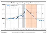
Demography
|
|
|
References
- ^ Landkreis Uckermark Wahl der Bürgermeisterin / des Bürgermeisters, accessed 4 July 2021.
- ^ "Bevölkerungsentwicklung und Flächen der kreisfreien Städte, Landkreise und Gemeinden im Land Brandenburg 2021" (PDF). Amt für Statistik Berlin-Brandenburg (in German). June 2022.
- ^ Detailed data sources are to be found in the Wikimedia Commons.Population Projection Brandenburg at Wikimedia Commons
Towns and municipalities in Uckermark | ||
|---|---|---|
|  | |
| International | |
|---|---|
| National | |
This Brandenburg location article is a stub. You can help Wikipedia by expanding it. |