
Tampin District | |
|---|---|
| Daerah Tampin | |
| Other transcription(s) | |
| • Jawi | تمڤين |
| • Chinese | 淡边县 |
| • Tamil | தம்பின் |
 Seal | |
 Location of Tampin District in Negeri Sembilan | |
 | |
 Tampin District Location of Tampin District in Malaysia | |
| Coordinates: 2°30′N 102°25′E / 2.500°N 102.417°E | |
| Country | |
| State | |
| Established as District | 1 July 1980 |
| Seat | Tampin |
| Local area government(s) | Tampin District Council |
| Government | |
| • District officer | Mohamed Roduan Ujang[1] |
| • Tunku Besar Tampin | Tunku Syed Razman al-Qadri |
| Area | |
| • Total | 878.69 km2 (339.26 sq mi) |
| Population (2010)[3] | |
| • Total | 82,545 |
| • Density | 94/km2 (240/sq mi) |
| Time zone | UTC+8 (MST) |
| • Summer (DST) | UTC+8 (Not observed) |
| Postcode | 73xxx |
| Calling code | +6-06 |
| Vehicle registration plates | N |
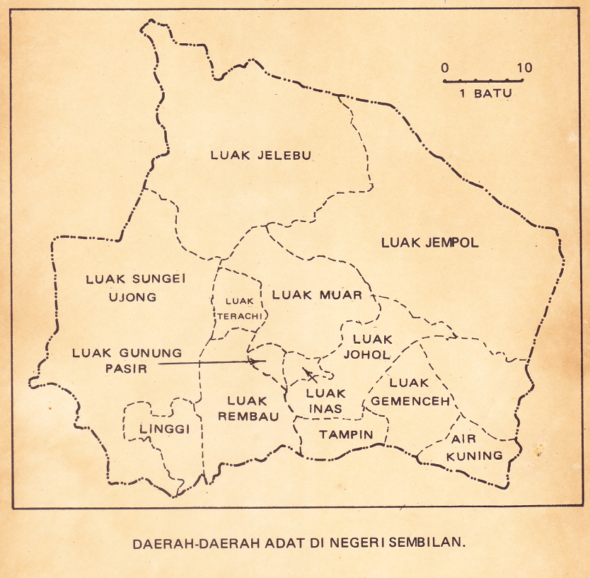
The Tampin District is a district in Negeri Sembilan, Malaysia. The district covers 878.69 square kilometres (339.26 sq mi) and is further divided into four adat socio-political provinces (luaks): Tampin Adat Territory (which includes the town of Tampin), Ayer Kuning, Gemencheh and Pasir Besar.[4]
Tampin District is surrounded by Tangkak and Segamat Districts, Johor to the southwest, Jasin and Alor Gajah Districts, Malacca to the south, Rembau District to the west, Kuala Pilah District to the northwest and Jempol District to the north. The geographical southern terminus of the Titiwangsa Mountains, the longest mountain range in Malaysia, is located in this district.
YouTube Encyclopedic
-
1/1Views:404
-
English Speech | English Story Telling Competition | English Speaking Practice
Transcription
Administrative divisions

Tampin District is divided into 7 mukims, which are:[5]
- Ayer Kuning
- Gemas
- Gemencheh
- Keru
- Repah
- Tampin Tengah
- Tebong
From the perspective of the adat, the district is governed separately by two different entities, where the mukims of Tampin Tengah, Repah, Keru and Tebong comprises the semi-autonomous Tampin Adat Territory governed by the Tunku Besar of Tampin, and the luaks of Gemencheh, Ayer Kuning and Pasir Besar (which includes Gemas) are protectorates of the Luak of Johol.
Demographics
| Year | Pop. | ±% |
|---|---|---|
| 1991 | 72,295 | — |
| 2000 | 77,021 | +6.5% |
| 2010 | 82,165 | +6.7% |
| 2020 | 88,101 | +7.2% |
| Source: [6] | ||
Federal Parliament and State Assembly Seats
List of Tampin district representatives in the Federal Parliament (Dewan Rakyat)
| Parliament | Seat Name | Member of Parliament | Party |
|---|---|---|---|
| P133 | Tampin | Mohd Isam Mohd Isa | Barisan Nasional (UMNO) |
List of Tampin district representatives in the State Legislative Assembly (Dewan Undangan Negeri)
| Parliament | State | Seat Name | State Assemblyman | Party |
|---|---|---|---|---|
| P133 | N34 | Gemas | Ridzuan Ahmad | Perikatan Nasional (BERSATU) |
| P133 | N35 | Gemencheh | Suhaimizan Bizar | Barisan Nasional (UMNO) |
| P133 | N36 | Repah | Veerapan Superamaniam | Pakatan Harapan (DAP) |
References
- ^ http://pdttampin.ns.gov.my/pdtt/my/organization/carta-organisasi
- ^ "Pejabat Daerah Dan Tanah Tampin - Latarbelakang". pdttampin.ns.gov.my.
- ^ "Population Distribution and Basic Demographic Characteristics, 2010" (PDF). Department of Statistics, Malaysia. Archived from the original (PDF) on 22 May 2014. Retrieved 19 April 2012.
- ^ "Daerah Adat Negeri Sembilan". Retrieved 15 January 2016.
- ^ http://apps.water.gov.my/jpskomuniti/dokumen/TAMPIN_PROFIL_JANUARI_2011.pdf [bare URL PDF]
- ^ "Key Findings of Population and Housing Census of Malaysia 2020" (pdf) (in Malay and English). Department of Statistics, Malaysia. ISBN 978-967-2000-85-3.
External links
Capital: Seremban, Royal town: Seri Menanti | |||||||||||
| Topics |
| ||||||||||
| Society | |||||||||||
| Administrative divisions |
| ||||||||||
| International | |
|---|---|
| National | |