Tabuk | |
|---|---|
| City of Tabuk | |
 Tabuk City Hall | |
 Flag  Seal | |
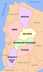
 Map of Kalinga with Tabuk highlighted | |
OpenStreetMap  | |
 Tabuk Location within the Philippines | |
| Coordinates: 17°24′25″N 121°26′33″E / 17.4069°N 121.4425°E | |
| Country | Philippines |
| Region | Cordillera Administrative Region |
| Province | Kalinga |
| District | Lone district |
| Founded | June 16, 1950 |
| Cityhood | June 23, 2007 (Lost cityhood in 2008 and 2010) |
| Affirmed Cityhood | February 15, 2011 |
| Barangays | 43 (see Barangays) |
| Government | |
| • Type | Sangguniang Panlungsod |
| • Mayor | Darwin C. Estrañero |
| • Vice Mayor | Dick G. Bal-o |
| • Representative | Allen Jesse C. Mangaoang |
| • City Council | Members |
| • Electorate | 70,281 voters (2022) |
| Area | |
| • Total | 700.25 km2 (270.37 sq mi) |
| Elevation | 293 m (961 ft) |
| Highest elevation | 1,338 m (4,390 ft) |
| Lowest elevation | 44 m (144 ft) |
| Population (2020 census)[3] | |
| • Total | 121,033 |
| • Density | 170/km2 (450/sq mi) |
| • Households | 25,731 |
| Economy | |
| • Income class | 5th city income class |
| • Poverty incidence | 10.60 |
| • Revenue | ₱ 1,186 million (2020) |
| • Assets | ₱ 2,841 million (2020) |
| • Expenditure | ₱ 1,006 million (2020) |
| • Liabilities | ₱ 390.9 million (2020) |
| Service provider | |
| • Electricity | Kalinga - Apayao Electric Cooperative (KAELCO) |
| Time zone | UTC+8 (PST) |
| ZIP code | 3800 |
| PSGC | |
| IDD : area code | +63 (0)74 |
| Native languages | Kalinga Ga'dang Ilocano Tagalog |
| Website | www |
Tabuk, officially the City of Tabuk (Ilocano: Siudad ti Tabuk; Filipino: Lungsod ng Tabuk), is a 5th class component city and capital of the province of Kalinga, Philippines. According to the 2020 census, it has a population of 121,033 people.[3]
History
The former municipal district of Tabuk was transformed into a regular municipality by Republic Act No. 533, approved June 16, 1950.[5]
Cityhood
Tabuk became the Cordillera's second city after Baguio on June 23, 2007, when 17,060 voters ratified Republic Act No. 9404. On November 18, 2008, the Supreme Court voted 6–5 to revert Tabuk, among other 15 cities', status back to municipalities. However, on December 21, 2009, the court reversed its first decision, returning Tabuk and the 15 other municipalities back to cities again. It contended that these cities were not covered by Republic Act 9009 – the law enacted in June 2001 that increased the income requirement for cities from P20 million to P100 million – as proven by transcripts of Senate debates while crafting RA 9009.
But on August 24, 2010, the court made a reversal again, reinstating its November 2008 decision, making Tabuk and the other 15 cities regular municipalities again. It concluded that the Local Government Code as amended by RA 9009 should be followed, without exception.
Finally, on February 15, 2011, Tabuk and the 15 municipalities became cities again after the court made a third reversal. This time the court acknowledged, among others, that the 16 cityhood laws amended RA 9009, effectively amending the Local Government Code itself.
After six years of legal battles, in its board resolution, the League of Cities of the Philippines acknowledged and recognized the cityhood of Tabuk and 14 other cities.
Geography
Tabuk City is 500 kilometres (310 mi) from Metro Manila.
Barangays
The City of Tabuk is politically subdivided into 43 barangays, 2 of which constitutes the poblacion. [6] These barangays are headed by elected officials: Barangay Captain, Barangay Council, whose members are called Barangay Councilors. All are elected every three years.
- Agbannawag
- Amlao
- Appas
- Bado Dangwa
- Bagumbayan
- Balawag
- Balong
- Bantay
- Bulanao
- Bulanao Norte
- Bulo
- Cabaritan
- Cabaruan
- Calaccad
- Calanan
- Casigayan
- Cudal
- Dagupan Centro (Poblacion)
- Dagupan West
- Dilag
- Dupag
- Gobgob
- Guilayon
- Ipil
- Lacnog
- Lacnog West
- Lanna
- Laya East
- Laya West
- Lucog
- Magnao
- Magsaysay
- Malalao
- Malin-awa
- Masablang
- Nambaran
- Nambucayan
- Naneng
- New Tanglag
- San Juan
- San Julian
- Suyang
- Tuga
Climate
| Climate data for Tabuk | |||||||||||||
|---|---|---|---|---|---|---|---|---|---|---|---|---|---|
| Month | Jan | Feb | Mar | Apr | May | Jun | Jul | Aug | Sep | Oct | Nov | Dec | Year |
| Mean daily maximum °C (°F) | 25 (77) |
27 (81) |
29 (84) |
32 (90) |
31 (88) |
31 (88) |
30 (86) |
30 (86) |
30 (86) |
29 (84) |
27 (81) |
26 (79) |
29 (84) |
| Mean daily minimum °C (°F) | 20 (68) |
20 (68) |
21 (70) |
23 (73) |
24 (75) |
24 (75) |
24 (75) |
24 (75) |
24 (75) |
23 (73) |
23 (73) |
21 (70) |
23 (73) |
| Average precipitation mm (inches) | 78 (3.1) |
60 (2.4) |
49 (1.9) |
51 (2.0) |
194 (7.6) |
197 (7.8) |
209 (8.2) |
226 (8.9) |
185 (7.3) |
180 (7.1) |
143 (5.6) |
183 (7.2) |
1,755 (69.1) |
| Average rainy days | 15.6 | 12.5 | 11.8 | 12.5 | 21.0 | 23.3 | 25.2 | 26.1 | 22.6 | 17.1 | 16.7 | 19.6 | 224 |
| Source: Meteoblue[7] | |||||||||||||
Demographics

| Year | Pop. | ±% p.a. |
|---|---|---|
| 1918 | 4,079 | — |
| 1939 | 3,343 | −0.94% |
| 1948 | 7,376 | +9.19% |
| 1960 | 21,261 | +9.22% |
| 1970 | 28,016 | +2.79% |
| 1975 | 33,918 | +3.91% |
| 1980 | 42,768 | +4.74% |
| 1990 | 57,200 | +2.95% |
| 1995 | 63,507 | +1.98% |
| 2000 | 78,633 | +4.69% |
| 2007 | 87,912 | +1.55% |
| 2010 | 103,912 | +6.27% |
| 2015 | 110,642 | +1.20% |
| 2020 | 121,033 | +1.78% |
| Source: Philippine Statistics Authority[8][9][10][11] | ||
In the 2020 census, the population of Tabuk was 121,033 people,[3] with a density of 170 inhabitants per square kilometre or 440 inhabitants per square mile.
Economy
Government
Local government
Tabuk, belonging to the lone congressional district of the province of Kalinga, is governed by a mayor designated as its local chief executive and by a city council as its legislative body in accordance with the Local Government Code. The mayor, vice mayor, and the councilors are elected directly by the people through elections which are held every three years.
Elected officials
| Position | Name |
|---|---|
| District Representative (Lone District of the Province of Kalinga) |
Allen Jesse C. Mangaoang |
| Chief Executive of the City of Tabuk | Mayor Darwin C. Estrañero |
| Presiding Officer of the City Council of Tabuk | Vice Mayor Dick G. Bal-o |
| Councilors of the City of Tabuk | Lucretina S. Sarol |
| Marc Rainier B. Duguiang | |
| Samuel B. Suma-al | |
| Eduardo A. Sacayle | |
| Chester A. Alunday | |
| Castor G. Cayaba | |
| Ivan S. Bagayao | |
| Kristian B. Wandag | |
| Abraham P. Licaycay | |
| Juan Thomas Duyan |
References
- ^ City of Tabuk | (DILG)
- ^ "2015 Census of Population, Report No. 3 – Population, Land Area, and Population Density" (PDF). Philippine Statistics Authority. Quezon City, Philippines. August 2016. ISSN 0117-1453. Archived (PDF) from the original on May 25, 2021. Retrieved July 16, 2021.
- ^ a b c Census of Population (2020). "Cordillera Administrative Region (CAR)". Total Population by Province, City, Municipality and Barangay. Philippine Statistics Authority. Retrieved July 8, 2021.
- ^ "PSA Releases the 2018 Municipal and City Level Poverty Estimates". Philippine Statistics Authority. December 15, 2021. Retrieved January 22, 2022.
- ^ "R.A. No. 533: An Act to Convert the Municipal District of Tabuk, Sub-province of Kalinga, Mountain Province, into a Regular Municipality to be known as the Municipality of Tabuk". PhilippineLaw.info. Archived from the original on January 4, 2015. Retrieved January 4, 2015.
- ^ "Province: Kalinga". PSGC Interactive. Quezon City, Philippines: Philippine Statistics Authority. Retrieved November 12, 2016.
- ^ "Tabuk: Average Temperatures and Rainfall". Meteoblue. Retrieved March 8, 2020.
- ^ Census of Population (2015). "Cordillera Administrative Region (CAR)". Total Population by Province, City, Municipality and Barangay. Philippine Statistics Authority. Retrieved June 20, 2016.
- ^ Census of Population and Housing (2010). "Cordillera Administrative Region (CAR)" (PDF). Total Population by Province, City, Municipality and Barangay. National Statistics Office. Retrieved June 29, 2016.
- ^ Censuses of Population (1903–2007). "Cordillera Administrative Region (CAR)". Table 1. Population Enumerated in Various Censuses by Province/Highly Urbanized City: 1903 to 2007. National Statistics Office.
{{cite encyclopedia}}: CS1 maint: numeric names: authors list (link) - ^ "Province of Kalinga". Municipality Population Data. Local Water Utilities Administration Research Division. Retrieved December 17, 2016.
- ^ "Poverty incidence (PI):". Philippine Statistics Authority. Retrieved December 28, 2020.
- ^ "Estimation of Local Poverty in the Philippines" (PDF). Philippine Statistics Authority. November 29, 2005.
- ^ "2003 City and Municipal Level Poverty Estimates" (PDF). Philippine Statistics Authority. March 23, 2009.
- ^ "City and Municipal Level Poverty Estimates; 2006 and 2009" (PDF). Philippine Statistics Authority. August 3, 2012.
- ^ "2012 Municipal and City Level Poverty Estimates" (PDF). Philippine Statistics Authority. May 31, 2016.
- ^ "Municipal and City Level Small Area Poverty Estimates; 2009, 2012 and 2015". Philippine Statistics Authority. July 10, 2019.
- ^ "PSA Releases the 2018 Municipal and City Level Poverty Estimates". Philippine Statistics Authority. December 15, 2021. Retrieved January 22, 2022.
- ^ "Tabuk City Election Results 2022". Retrieved November 26, 2023.
External links
- Official website
- Philippine Standard Geographic Code
- Philippine Census Information
- Local Governance Performance Management System
Places adjacent to Tabuk, Kalinga | |
|---|---|
Tabuk (capital and largest city) | |
| Municipalities | |
| Component city | |
| Barangays | |