
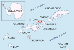
 Location of Aitcho Islands in the South Shetland Islands | |
 Table Island Location of Table Island  Table Island Table Island (Antarctic Peninsula) | |
| Geography | |
|---|---|
| Location | Antarctica |
| Coordinates | 62°20′34.8″S 59°48′29.7″W / 62.343000°S 59.808250°W |
| Archipelago | South Shetland Islands |
| Area | 1.12 km2 (0.43 sq mi) |
| Length | 1.4 km (0.87 mi) |
| Width | 1.0 km (0.62 mi) |
| Highest elevation | 150 m (490 ft) |
| Administration | |
| Administered under the Antarctic Treaty System | |
| Demographics | |
| Population | uninhabited |

Table Island is a conspicuous flat-topped, rocky island lying north of Greenwich Island and north-northwest of the Aitcho group on the west side of English Strait in the South Shetland Islands, Antarctica. The island is rising to over 150 metres (492 feet) and extending 1.4 by 1 kilometre (0.87 by 0.62 miles), with a surface area of 112 hectares (280 acres).[1] It is separated from Aitcho Islands to the south-southeast by the 1.9-kilometre (1.2-mile) wide Klimash Passage.
Turmoil Rock (62°21′17.9″S 59°47′02.5″W / 62.354972°S 59.784028°W) is lying 1.32 kilometres (0.82 miles) southeast of Table Island and 1.65 km (1.03 mi) north-northeast of Morris Rock. The area was visited by early-19th-century sealers.
The island was descriptively named by sealers from its shape, while the rock was descriptively named from the breakers it creates, following a survey from HMS Protector in 1967.
YouTube Encyclopedic
-
1/4Views:470138 296432361
-
Rousay, the Egypt of the North: the story from the sea
-
Beach With Giant Waves Protected By Stone Wall in Puerto Rico
-
The Best Way To Avoid Farmed Salmon in a Restaurant
-
Education in Scotland
Transcription
Location
The midpoint of Table Island is located at 62°20′34.8″S 59°48′29.7″W / 62.343000°S 59.808250°W and the island lies 4.85 km (3.01 mi) northwest of Fort William, Robert Island, 7.9 km (4.9 mi) north of Dee Island, 2.5 km (1.6 mi) north of Morris Rock, 4.14 km (2.57 mi) north by east of Holmes Rock, 6.1 km (3.8 mi) northeast of Romeo Island, 2.76 km (1.71 mi) southwest of Potmess Rocks and 4.68 km (2.91 mi) west by south of Rogozen Island (British mapping in 1820, 1821, 1822, 1935 and 1968, Spain in 1861, Chilean in 1947, Argentine in 1980, and Bulgarian in 2005 and 2009).
See also
References
- ^ L.L. Ivanov. Antarctica: Livingston Island and Greenwich, Robert, Snow and Smith Islands. Scale 1:120000 topographic map. Troyan: Manfred Wörner Foundation, 2009. ISBN 978-954-92032-6-4
External links

This Greenwich Island location article is a stub. You can help Wikipedia by expanding it. |