
 Satellite photograph of Tabiteuea (NE top) | |
 | |
 Tabiteuea 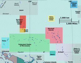 Tabiteuea  Tabiteuea  Tabiteuea | |
| Geography | |
|---|---|
| Location | Pacific Ocean |
| Coordinates | 1°21′S 174°48′E / 1.350°S 174.800°E |
| Archipelago | Gilbert Islands |
| Major islands | Aanikai |
| Area | 40.33 km2 (15.57 sq mi) |
| Highest elevation | 3 m (10 ft) |
| Administration | |
| Capital | Utiroa |
| Former capital | Buariki |
| Demographics | |
| Population | 5,261 (2015 Census) |
| Pop. density | 123.8/km2 (320.6/sq mi) |
| Ethnic groups | I-Kiribati 99.7% |
Tabiteuea (formerly Drummond's Island) is an atoll in the Gilbert Islands, Kiribati, farther south of Tarawa. This atoll is the second largest and the most populated of the Gilbert Islands after Tarawa. The atoll consists of one main island, Aanikai in the north, and several smaller islets in between along the eastern rim of the atoll. The atoll has a total land area of 38 km2 (15 sq mi), while the lagoon measures 365 km2 (141 sq mi). The population numbered 5,261 in 2015. The islanders have customary fishing practices related to the lagoon and the open ocean.[1]
While most atolls of the Gilbert Islands correspond to local government areas governed by island councils, Tabiteuea, like the main atoll Tarawa, is divided into two:
- North Tabiteuea (in Gilbertese, Tabiteuea Meang) has a land area of 26 km2 (10 sq mi) and a population of 3,955 as of 2015[update], distributed among twelve villages (capital Utiroa)[2]
- South Tabiteuea (Tabiteuea Maiaki) has a land area of 12 km2 (4.6 sq mi) and a population of 1,306, distributed among six villages (capital Buariki).[3]
YouTube Encyclopedic
-
1/5Views:6733 62811 038 8207987 901
-
Tewai Tabiteuea
-
Besøk på Tabiteuea South
-
Kiribati: a drowning paradise in the South Pacific | DW Documentary
-
OMG! My Favourite Kiribati dance
-
Kiribati Island|| 4K 2019|| Top 10 Secret List to do when you get into the island.
Transcription
History
"Tabiteuea" is Gilbertese for "no chief allowed"; the island is traditionally egalitarian and is known for its huge maneaba.
On 1 July 1799, Charles Bishop and George Bass entered in the lagoon of Tabiteuea and many canoes visited his brig Nautilus. Bishop called it Bishop’s Island, and called Aanikai, Drummond’s Island.[4]
The Battle of Drummond's Island occurred during the United States Exploring Expedition in April 1841 at Tabiteuea, then known as Drummond's Island. After one sailor from sloop USS Peacock, was missing without reason, the US party decided on exacting redress for the incident. Twelve islanders were killed in the fighting and others were wounded. Utiroa village with more than 1,000 inhabitants, was burned and erased.[5]
During the American Civil War, the Confederate States Navy steamer CSS Shenandoah visited the island on March 23, 1865 in search of United States whalers, but the whalers had fled the area. Captain James Waddell described the islanders as "of copper colour, short of statue, athletic in form, intelligent and docile" and were "without a stitch of clothing".[6]
In the late 1800s, the two parts of the island were the site of a religious war when the populace of North Tabiteuea, partly converted to Christianity and, led by a Hawaiian pastor called Kapu who had assembled a "hymn-singing army on a crusade", invaded and conquered South Tabiteuea, where was recently (1860) created a cult of Tioba (Jehovah).[7]
Bishop Octave Terrienne built his main Catholic Church in Tanaeang, North Tabiteuea in 1936 and established there the see of his apostolic vicariate of the Gilbert and Ellice Islands.[8]
Tabiteuea Post Office opened around 1911 and was renamed Tabiteuea North around 1972. Tabiteuea South Post Office opened on 13 September 1965.[9]

Education
There is a government high school, Tabiteuea North Senior Secondary School,[10] also known as Teabike College.[11] Located in Eita, it serves the entire island.[12]
There is also a government junior high school, Takoronga School in Terikiai, serving all of Tab North.
The elementary schools on Tab North are all government schools. They include:[12]
- Aiwa: Nukantewaa School, which also serves Bangai
- Buota: Taunibong School, which also serves Tanaeang
- Eita: Temwamwang School, which serves a portion of Eita as well as Utiroa; the school does not serve all of Eita, as Eita and Utiroa are both the settlements with the most people in Tabiteuea North.
Taunibong School in Buota serves as the elementary school. The area junior high school is Takoronga School in Terikiai, and the area senior high school is Tabiteuea North Senior Secondary School a.k.a. Teabike College in Eita.[12]
- Kabuna: Kabuna School
- Tekaman: Burannikoraoi School, which also serves Tekabwibwi
- Terikiai: Takoronga School, which also serves a section of Eita; Kiribati authorities included a section of Eita in its attendance zone to relieve Temwamwang School
- Tanaatoorua: Ueen Maungan te Raoi School, which also serves Bangai
- Taumwa: Auriaria School
- Taku: Taku School
Students from Bangai may attend either Nukantewaa School or Ueen Maungan te Raoi School; Bangai does not have enough residents, so the Kiribati authorities do not operate a school there.[12]
Transport
There are two domestic airports:
- Tabiteuea North Airport that is the main hub serving the southern Gilbert Islands;
- Tabiteuea South Airport, only serving South Tabiteuea.
Gallery
-
 A drawing by Alfred Thomas Agate featuring a warrior of Drummond Island in 1841
 -

References
- ^ Luomala, Katharine (1980). "Some fishing customs and beliefs in Tabiteuea (Gilbert Islands, Micronesia)". Anthropos. 75:3/4: 523–558.
- ^ "12. Tabiteuea North" (PDF). Office of Te Beretitent - Republic of Kiribati Island Report Series. 2012. Retrieved 28 April 2015.
- ^ "13. Tabiteuea South" (PDF). Office of Te Beretitent - Republic of Kiribati Island Report Series. 2012. Retrieved 28 April 2015.
- ^ Dumas, Guigone (2014). Tabiteuea, Kiribati. Paris: Hazan. pp. 51–52. ISBN 9-782754-10787-7.
- ^ Ellsworth, Harry A. (1974). One Hundred Eighty Landings of United States Marines 1800 to 1934. Washington D.C.: US Marines History and Museums Division. pp. 72–74.
- ^ WADDELL, James C.S.S. Shenandoah: The Memoirs of Lieutenant Commanding James I. Waddell, 1996, ISBN 1-55750-368-0, p.143
- ^ MACDONALD, Barrie, Cinderellas of the Empire: Towards a history of Kiribati and Tuvalu, 2001, ISBN 982-02-0335-X, p.38
- ^ Dumas, Guigone (2014). Tabiteuea, Kiribati. Paris: Hazan. pp. 68–69. ISBN 9-782754-10787-7.
- ^ Premier Postal History. "Post Office List". Premier Postal Auctions. Retrieved 5 July 2013.
- ^ "VSA Assignment Description Assignment title English Language Trainer (of Trainers/ Teachers) Country Kiribati." Volunteer Service Abroad (Te Tūao Tāwāhi). Retrieved on 6 July 2018. p. 6-7.
- ^ "TABITEUEA NORTH 2008 Socio-Economic Profile" Part 2 of 4. Strengthening Decentralized Governance in Kiribati Project , Ministry of Internal and Social Affairs (Kiribati). p. 48 (PDF p. 13/15). Part 1 is here.
- ^ a b c d "TABITEUEA NORTH 2008 Socio-Economic Profile" Part 2 of 4. Strengthening Decentralized Governance in Kiribati Project , Ministry of Internal and Social Affairs (Kiribati). p. 42 (PDF p. 7/15). Part 1 is here.
External links
- Exhibit: The Alfred Agate Collection: The United States Exploring Expedition, 1838-1842 from the Navy Art Gallery
| Gilbert Islands |  | |
|---|---|---|
| Phoenix Islands | ||
| Line Islands | ||
| West of Gilberts | ||
| Reefs | ||
| ||
| International | |
|---|---|
| National | |