
Supía, Caldas | |
|---|---|
Municipality and town | |
 Flag  Seal | |
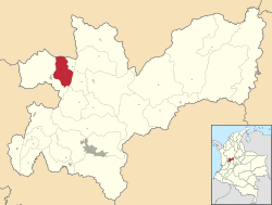 Location of the municipality and town of Supía, Caldas in the Caldas Department of Colombia. | |
 Supía, Caldas Location in Colombia | |
| Coordinates: 5°27′2″N 75°39′5″W / 5.45056°N 75.65139°W | |
| Country | |
| Department | |
| Elevation | 1,183 m (3,881 ft) |
| Population (Census 2018[1]) | |
| • Total | 26,571 |
| Time zone | UTC-5 (Colombia Standard Time) |
Supía is a town and municipality in the Colombian Department of Caldas. Located along the Colombian coffee growing axis, it was part of the "Coffee Cultural Landscape" UNESCO World Heritage Site in 2011. [2]
YouTube Encyclopedic
-
1/3Views:3 0132 0641 722
-
42 Llegando a Supía, Caldas. Tour en moto por Colombia.
-
43 Supía - Caldas 1/3. Tour en moto por Colombia.
-
40 Carretera Riosucio - Supía, Caldas 1/2. Tour en moto por Colombia
Transcription
References
- ^ "Censo Nacional de Población y Vivienda 2018" (in Spanish). Retrieved 20 April 2020.
- ^ "Coffee Cultural Landscape". UNESCO World Heritage List. United Nations Educational, Scientific, and Cultural Organization. Retrieved 25 Apr 2011.
Capital: Manizales | |||||||||||||
| Districts and municipalities |
| ||||||||||||
5°28′N 75°39′W / 5.467°N 75.650°W
This Caldas Department location article is a stub. You can help Wikipedia by expanding it. |