

Straight is an unincorporated community in Texas County in the Oklahoma Panhandle, United States.[1]
Straight is located 13.69 miles west of Hooker and 15 miles north of Guymon. Oklahoma State Highway 135 passes two miles to the west and the community of Mouser is two miles to the east.[2] Pony Creek (a tributary to the Beaver River), flows past to the southwest of the community and Wild Horse Lake is approximately two miles to the north.[3]
The Beaver, Meade and Englewood Railroad built through the area in the 1929-1930 timeframe,[4] and Straight was purposely sited along its tracks.[5] That line was abandoned in 1972.[6]
YouTube Encyclopedic
-
1/1Views:101 442
-
Scared Straight: 20 Years Later - PART 4
Transcription
References
- ^ U.S. Geological Survey Geographic Names Information System: Straight, Oklahoma
- ^ Oklahoma Atlas & Gazeteer, DeLorme, 1st ed., 1998, p. 15 ISBN 0899332838
- ^ Straight and Straight SW, 7.5 minute Topographic Quadrangles, USGS, 1967
- ^ "Construction Strategies of Railroads in the Oklahoma Panhandle". Donovan L. Hofsommer, Chronicles of Oklahoma, Vol. 58, No 1, Spring 1980, pp. 82-89. Retrieved December 6, 2021.
- ^ "Texas County". Dianna Everett, Oklahoma Historical Society. Retrieved December 6, 2021.
- ^ "The Beaver, Meade and Englewood Railroad". AbandonedRails.com. Retrieved December 6, 2021.
Municipalities and communities of Texas County, Oklahoma, United States | ||
|---|---|---|
| Cities | 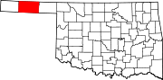 | |
| Towns | ||
| CDPs | ||
| Other communities | ||
36°52′36″N 101°26′55″W / 36.87667°N 101.44861°W
This Oklahoma state location article is a stub. You can help Wikipedia by expanding it. |