

State Highway 86 (abbreviated SH-86) is a state highway in the U.S. state of Oklahoma that connects SH-51 with Perry and is 12.06 miles (19.41 km) long. The highway is contained wholly in Payne and Noble Counties. SH-86 has no lettered spurs or loops.
SH-86 was established in 1940. Initially a gravel highway, it remained unpaved until 1952.
YouTube Encyclopedic
-
1/2Views:23 679307
-
AASHTO T 176 Sand Equivalent Test
-
New Graduate Memberships
Transcription
Route description
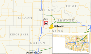
SH-86 begins at SH-51 in western Payne County, approximately 3+1⁄2 miles (5.6 km) east of Interstate 35. From this intersection, SH-86 heads north, crossing Stillwater Creek, just west of where it expands to form Lake Carl Blackwell, around two miles (3.2 km) north of SH-51.[3] SH-86 crosses into Noble County 3.01 miles (4.84 km) into its journey.[1] In Noble County, the highway mostly follows a due north course, except for a slight curve approximately two miles (3.2 km) south of Perry. The route passes just west of Lake Perry. Shortly thereafter, SH-86 comes to an end in Perry at US-77.[3]
History
State Highway 86 first appears on the official Oklahoma highway map on the 1941 edition. Originally, the driving surface consisted of untreated gravel. The route had the same extent and termini as the present-day highway.[4] By 1953, the highway had been paved.[5]
Junction list
| County | Location | mi[1][2] | km | Destinations | Notes |
|---|---|---|---|---|---|
| Payne | | 0.00 | 0.00 | Southern terminus | |
| Noble | Perry | 12.06 | 19.41 | Northern terminus | |
| 1.000 mi = 1.609 km; 1.000 km = 0.621 mi | |||||
References
- ^ a b c Oklahoma Department of Transportation (n.d.). Control Section Maps: Payne County (PDF) (Map) (2010–2011 ed.). Scale not given. Oklahoma City: Oklahoma Department of Transportation. Retrieved September 27, 2012.
- ^ a b Oklahoma Department of Transportation (n.d.). Control Section Maps: Noble County (PDF) (Map) (2010–2011 ed.). Scale not given. Oklahoma City: Oklahoma Department of Transportation. Retrieved September 27, 2012.
- ^ a b Oklahoma Atlas and Gazetteer (Map). 1:200,000. DeLorme. 2006. p. 32.
- ^ Map Showing Condition of Improvement of the State Highway System (PDF) (Map) (April 1941 ed.). Oklahoma Department of Highways. Retrieved December 1, 2012.
- ^ Highways of Oklahoma (PDF) (Map). Oklahoma Department of Highways. 1953. Retrieved December 1, 2012.