
South Carolina Highway 177 | ||||
|---|---|---|---|---|
 | ||||
| Route information | ||||
| Maintained by SCDOT | ||||
| Length | 7.820 mi[1] (12.585 km) | |||
| Existed | 1960[citation needed]–present | |||
| Major junctions | ||||
| South end | ||||
| North end | ||||
| Location | ||||
| Country | United States | |||
| State | South Carolina | |||
| Counties | Marlboro | |||
| Highway system | ||||
| ||||

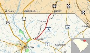
South Carolina Highway 177 (SC 177) is a 7.820-mile (12.585 km) primary state highway in the U.S. state of South Carolina. It connects the community of Wallace with Hamlet, North Carolina.
YouTube Encyclopedic
-
1/3Views:2 0421 044391
-
Two Lane Backroads out of Harrisburg, New York on State Route 177
-
I-26 East - Charleston - South Carolina - 4K Highway Drive
-
US Highway 177 - Interstate 40 to Warwick - Oklahoma | Drive America's Highways 🚙
Transcription
Route description
SC 177 is a two-lane rural highway that traverses from Wallace at SC 9 to the North Carolina state line.[2]
History
The highway was established in 1960 as a renumbering of SC 77, little has changed since.[3][4]
Two predecessors existed before the current SC 177 came to existence. The first appeared from 1930-1936 as a new primary routing from U.S. Route 176 (US 176)/SC 10 in Spartanburg to the North Carolina state line[where?]; it eventually became part of SC 9. The second appeared from 1938-1951 as a new primary routing from US 176 southeast of Pomaria to US 76/SC 2 near Ballentine. It was adjusted twice, in 1948 extending and replacing SC 664, and in 1950 shifting to meet with US 176/SC 121 split. It was eventually renumbered as an extension of US 176.[5]
South Carolina Highway 77
South Carolina Highway 77 | |
|---|---|
| Location | Wallace, South Carolina-NC State Line |
| Length | 7.82 mi[6] (12.59 km) |
| Existed | 1937–1960 |
South Carolina Highway 77 (SC 77) was established in 1937 as a renumbering of SC 98 from Wallace to the North Carolina state line. In 1960, this became SC 177.[3][failed verification]
Another SC 77 reappeared only appeared on South Carolina official maps in 1981-1982 as a proposed segment of Interstate 77 (I-77) from US 76/US 378 to I-20. When the freeway eventually opened, it was simply labeled as I-77.
South Carolina Highway 664
South Carolina Highway 664 (SC 664) was established in 1941 or 1942 as a new primary routing between SC 177 and US 176. In 1948, it was renumbered to SC 177.[5]
Major intersections
The entire route is in Marlboro County.
| Location | mi[1] | km | Destinations | Notes | |
|---|---|---|---|---|---|
| Wallace | 0.000 | 0.000 | Southern terminus | ||
| | 7.820 | 12.585 | Continuation into North Carolina | ||
| 1.000 mi = 1.609 km; 1.000 km = 0.621 mi | |||||
See also
References
- ^ a b "Highway Logmile Report". South Carolina Department of Transportation. Retrieved December 25, 2020.
- ^ Google (September 5, 2012). "Overview map of SC 177" (Map). Google Maps. Google. Retrieved September 5, 2012.
- ^ a b General Highway Map, Marlboro County, South Carolina (PDF) (Map). Cartography by SCDOT. South Carolina Department of Transportation. 1943. Retrieved September 10, 2013.
- ^ General Highway Map, Marlboro County, South Carolina (PDF) (Map). Cartography by SCDOT. South Carolina Department of Transportation. 1967. Retrieved September 10, 2013.
- ^ a b General Highway Map, Newberry County, South Carolina (PDF) (Map). Cartography by SCDOT. South Carolina Department of Transportation. 1943. Retrieved September 10, 2013.
- ^ "Statewide Highways 2012" (ZIP). South Carolina Department of Transportation. 2012.
External links
 Media related to South Carolina Highway 177 at Wikimedia Commons
- Former SC 77 at Virginia Highways' South Carolina Highways Annex
- SC 177 at Virginia Highways' South Carolina Highways Annex
- Former SC 664 at Virginia Highways' South Carolina Highways Annex