
Smith's Ferry | |
|---|---|
 Riverside clubhouse of the Holyoke Canoe Club, Smith's Ferry | |
 Smith's Ferry  Smith's Ferry  Smith's Ferry | |
| Coordinates: 42°15′30.33″N 72°36′51.32″W / 42.2584250°N 72.6142556°W | |
| Country | United States |
| State | Massachusetts |
| City | Holyoke |
| Wards | 7 |
| Precincts | 7A |
| Annexed | June 9, 1909 |
| Area | |
| • Total | 5.94 sq mi (15.4 km2) |
| Elevation | 128 ft (39 m) |
| ZIP code | 01040 |
| Area code | 413 |
| GNIS feature ID | 609085[2] |
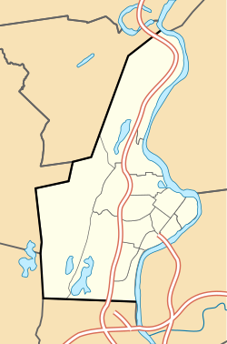
Smith's Ferry is a neighborhood in Holyoke, Massachusetts, United States, located to the north of the city center, approximately 1.5 miles (2.4 km) from downtown. The neighborhood prominently features the Mount Tom State Reservation, as well as the Mountain Park Amphitheater, the Dinosaur Footprints Reservation, and several other recreational and historic venues. Smith's Ferry is the second largest geographic division in Holyoke after Rock Valley, comprising roughly 3,800 acres (1,500 ha) of mixed residential, commercial, and recreational zoning.[1]
YouTube Encyclopedic
-
1/3Views:1 88753312 067
-
Pittsfield, Massachusetts
-
Salem, Massachusetts
-
Penn Foster College | Vet Tech Program | Vlog #1
Transcription
History


The namesake of Smith's Ferry was one of the many ferry operators who navigated the Connecticut prior to the construction of the Joseph E. Muller Bridge and South Hadley Falls Bridge in Holyoke. The first ferry began operation in 1658, long before the establishment of the city, and others continued operating between the east and west riverbanks through the early 20th century.[3]
By 1704, around half a dozen families lived in Smith's Ferry, often banding together at nights and "forting" in a single house to stave off attacks from the local natives.[4] Months after the successful Raid on Deerfield during Queen Anne's War, on May 13, 1704, a number of tribesmen attacked Easthampton in the Pascommuck Massacre. Several of these men would go on to attack Smith's Ferry, crossing over the Mount Tom Range and setting fire to the homestead of Benjamin Wright. Ultimately they would be repelled by the village settlers; one native was killed during the skirmish.[5]: 17
Smith's Ferry remained a vestige of the original boundaries of Northampton for much of its existence, and was formerly known as the Old Mountain Division East Lots. The boundaries between it and the rest of Northampton were divided, however, by a small tract of land in Easthampton to the south of The Oxbow.[6] While the land was officially governed by the City of Northampton, it was often the Holyoke Fire Department that had to respond to emergency calls in the area.[7]
For these reasons the idea for annexing some of the territory was introduced to the legislature in 1908 but was opposed by the Holyoke Canoe Club and country club (now known as the Wyckoff Country Club), as it did not call for annexation of the entirety of the discontinuous territory.[8]
The movement to annex the neighborhood gained considerable momentum when on March 21, 1909, the canoe club's property burned to the ground due to a grass fire ignited by sparks from a passing locomotive. Some boys who had seen that the grass was on fire ran to the residence of J. Lewis Wyckoff, a prominent figure in the community, and ultimately alarm was given to the Highlands fire station. The Northampton fire department received a call about the fire but was unable to respond due to the condition and distance of the roads between their fire station and the club. By the time Holyoke firefighters arrived, the building was considered a total loss; however, they were able to extinguish flames that had spread to the adjacent railroad ties and telephone poles.[9] In return for their services, the canoe club paid the Holyoke fireman's aid association a sum of $25, which resulted in a rebuke from the city of Northampton, seen as the city overstepping its bounds.[10] Days later a writer from the Springfield Republican would criticize how "Smiths Ferry [sic] residents are told by Northampton, on the one hand that they should be satisfied with what they are not getting, [while] Holyoke is severely censured on the other hand for offering to give them any of the conveniences of life."[11] Ultimately the fire became a driving force in the call for annexation; weeks later, a legislative committee on cities arrived in Holyoke and toured the clubhouse ruins with Wyckoff.[12]

Frustrated by the lack of services, the residents of Smith's Ferry successfully petitioned to join Holyoke, and on June 9, 1909, the Massachusetts Legislature passed an act allowing the land to be annexed by the City of Holyoke. In return for his advocacy for the act, Wyckoff was given the key to the city.[13] At the time of its passage, the act required the City of Holyoke pay $7,000 to the Hampshire County government to compensate for the construction of the state road in the area. The act also mandated that the City of Holyoke pay the City of Northampton a sum of $55,000 for the land, for which the City would issue bonds to repay.[14] In total the annexation cost $62,000 at the time, the equivalent of $1.5 million in 2016 US dollars.[15]
During the 20th century the area was home to the Mount Tom Station, the last coal power plant in Massachusetts, which closed in 2014. One of the few businesses in the largely residential neighborhood, was the Mount Tom Greenhouse company, which produced flowers for local florists from about 1950 to 1981.[16][17] Today the area is still home to the Jericho, a community center for disabled children and adults operated by the Diocese of Springfield.
Geography
Geology

Smith's Ferry contains a unique mix of sedimentary and igneous rocks due to its proximity to a Mesozoic Rift Basin, where volcanic surface flows once manifested due to continental rifts that arose with the tectonic dispersal of Pangaea. Those rifts which were aborted created igneous deposits along various inland landscapes such as the Connecticut River Valley.[18]
The area's igneous activity from the Jurassic period has left a landscape of Holyoke and black-rock diabase in and around Mt. Tom, the former being created by surface lava flow and the latter as it was forced through layers of subterranean sandstone where it became deposited as an igneous mass. Basalt also occurs in the area due to the former volcanic activity. Sedimentary rocks abut the igneous deposits with large swaths of arkosic sandstone extant along the banks of the Connecticut River.[19] It is on this sandstone that dinosaur tracks from Early Jurassic can be found. These tracks were once so prevalent that they could be readily found by land-owners who would often chisel them away from the landscape and sell them to tourists. Construction of I-91 along Mt. Tom was briefly delayed in the mid-1960s when several slabs of dinosaurs were discovered from blasting in the area.[20]
Transportation
Streets and highways
The most prominent road in Smith's Ferry is U.S. Route 5 which traverses the entire length of the region. PVTA bus route B48 passes through this highway but does not, however, have any marked stops there.[21] This span of highway also contains a marked bike lane separated from traffic by a painted median.[22][23]
U.S. Interstate 91 largely defines the boundaries of the southeast side of Mount Tom State Reservation but is only accessible to the immediate north or south of the neighborhood via Exit 18 in Northampton and Exit 17 on MA Route 141 respectively.[23]
Rail
The railway in Smith's Ferry was originally a part of the Connecticut River Railroad system, with a homonymous passenger station which served the Mount Holyoke Seminary during the 19th century.[24] While there are no passenger or freight stops in Smith's Ferry today, the track which traverses the area is serviced by Pan Am Southern, which operates a freight line from Hartford to White River Junction.[25]
The railroad is also a part of the Vermonter Amtrak route which began service between stations in downtown Holyoke and Northampton in August 2015.[26]
Government
The neighborhood lies in the 7th Ward of the City of Holyoke, and is locally represented by Councilman Todd McGee as well as members elected-at-large including Councilman Daniel Bresnahan, Councilman Howard B. Greaney, Councilman Michael J. Sullivan, Councilman James M. Leahy, Councilwoman Rebecca Lisi, Councilman Diosdado Lopez, Councilman Joseph M. McGiverin, and Councilman Peter R. Tallman.[27]
See also
References
- ^ a b Spatial analysis of "Holyoke Neighborhoods" (PDF). Retrieved 3 Jun 2016.
- ^ a b "Smith's Ferry, Holyoke, Massachusetts". Geographic Names Information System. United States Geological Survey, United States Department of the Interior. Retrieved 3 Jun 2016.
- ^ "Fun on the Ferry". Gaylord Memorial Library. 26 February 2010. Archived from the original on 30 June 2016.
- ^ Zack, Charles Sumner (1919). Holyoke in the Great War. Transcript Publishing Company. p. 373.
- ^ Allyn, George H. (1912). Thirtieth Anniversary Sketch, Holyoke Daily Transcript, 1882–1912. The Transcript Publishing Co. OCLC 24571746.
- ^ Frederick W. Beers (1873). "Northampton & Easthampton" (Map). County atlas of Hampshire, Massachusetts. 1:31680 "2 inches to the mile". New York: F.W. Beers & Co.
- ^ "The Holyoke Timeline, 1909–1949". Chronos Historical Services. Archived from the original on 3 April 2016.
- ^ "Will oppose annexation bill". Springfield Republican. Springfield, Mass. March 24, 1908. p. 10.
- ^ "Old Canoe Club-House Burned". Springfield Republican. Springfield, Mass. March 22, 1909. p. 10.
- ^ "Holyoke". Springfield Republican. Springfield, Mass. March 25, 1909. p. 10.
The firemen's aid association has received a check for $25 from the Holyoke canoe club in recognition of the excellent work of the firemen at the fire at the old canoe club house last Sunday
- ^ "The Holyoke Canoe Club Fire; Its Effect on Annexation". Springfield Republican. Springfield, Mass. March 28, 1909. p. 17.
- ^ "Holyoke; Legislators See the Sights, Visit the Disputed Strip". Springfield Republican. Springfield, Mass. April 3, 1909. p. 12.
- ^ DiCarlo, Ella Merkel (1982). Holyoke–Chicopee, a Perspective; 1882-1982. Transcript-Telegram Co. pp. 238–239. OCLC 9299261.
- ^ "An act to establish the boundary line between the cities of Northampton and Holyoke". Massachusetts General Law No. Ch. 480 of June 9, 1909 (PDF). p. 498-502. Archived (PDF) from the original on June 30, 2016. Retrieved 30 June 2016.
- ^ "Inflation Calculator". Bureau of Labor Statistics, U.S. Department of Labor.
- ^ "Northampton and Holyoke Florists to Have Display". Springfield Union. Springfield, Mass. March 3, 1957. p. 47.
A special committee of floral decorators, headed by Robert Fitzgerald of the Mount Tom greenhouse, president of the association, has been busily at work for many weeks preparing to compete for their eighth prize winner.
- ^ [Query- "Mt. Tom Greenhouse, Inc."], Massachusetts Corp. Card Search, Corporation Cards of the Commonwealth of Massachusetts, Secretary of the Commonwealth
- ^ "Mesozoic Basins". Geology of National Parks, 3D and Photographic Tours. U.S. Geologic Survey. Archived from the original on 1 May 2015. Retrieved 3 Jun 2016.
- ^ Pynchon, W.H.C. (1905). Fuller, Myron L. (ed.). "Drilled Wells of the Triassic Area of the Connecticut Valley". Contribution to the Hydrology of Eastern United States. United States Geologic Survey: 70–71.
- ^ "Dinosaurs Block Road in Holyoke". Boston Globe. Boston. 14 July 1964. p. 1.
Discovery of tracks of the prehistoric monsters has halted blasting for Interstate Rte. 91 near the Connecicut [sic] River. Workmen found the tracks, which resemble those of an enormous chicken, imbedded in rock close to the foot of Mt. Tom. Paleontologists have confirmed the find.
- ^ "Blue 48 - Northampton/Veterans Park - connect to Holyoke Mall". Pioneer Valley Transit Authority. Archived from the original on 12 April 2016. Retrieved 5 July 2016.
- ^ Planners Collaborative, Inc. (September 2008). Massachusetts Bicycle Transportation Plan (PDF) (Report). Massachusetts Executive Office of Transportation. p. 40. Archived from the original (PDF) on 1 July 2016. Retrieved 5 July 2016.
- ^ a b Google (5 July 2016). "Smith's Ferry, Holyoke, Massachusetts" (Map). Google Maps. Google. Retrieved 5 July 2016.
- ^ Green, John M. (1872). Thirty-Fifth Annual Catalogue of the Mount Holyoke Female Seminary in South Hadley, Mass. Northampton: Bridgman & Childs, Publishers. p. 24.
All persons wishing to come to the Seminary should stop at the 'Smith's Ferry' Station on the Connecticut River R. R., where the stages are in waiting on the arrival of each of the trains. Arrangements have been perfected whereby Tickets and Checks for Baggage can be obtained in New York City, Boston, Albany, and all the large towns on the Boston and Albany R. R. direct for Smith's Ferry.
- ^ Otto M. Vondrak (2014). "System Map" (Map). Pan Am Railways. 1:316800. North Billerica, MA: Pan Am Railways. Archived from the original on 28 December 2013.
- ^ Kinney, Jim (20 August 2015). "Opening date set for Holyoke Amtrak train station". MassLive. Advance Digital. Archived from the original on 4 March 2016.
- ^ "Councilors". City of Holyoke. 26 February 2010. Retrieved 7 July 2016.
Further reading
- Corbin, Walter E. (July 20, 1932). The Cemetery at Smith's Ferry; in Northampton until June 9, 1909, then in Holyoke. Florence, Mass.
{{cite book}}: CS1 maint: location missing publisher (link)
External links
- The Holyoke Canoe Club, a canoe, tennis, and swim club
- The Redcliff Canoe House, a historical clubhouse on the Connecticut River
- Holyoke Country Club, a 9-hole golf course located to the north of Mount Tom
- Wyckoff Country Club, an 18-hole golf course located to the south of Mount Tom
