
Sirjan County
Persian: شهرستان سیرجان | |
|---|---|
County | |
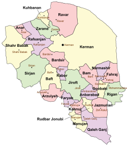 Location of Sirjan County in Kerman province (center left, green) | |
 Location of Kerman province in Iran | |
| Coordinates: 29°20′N 55°32′E / 29.333°N 55.533°E[1] | |
| Country | |
| Province | Kerman |
| Capital | Sirjan |
| Districts | Central, Balvard, Golestan, Pariz, Zeydabad |
| Population (2016) | |
| • Total | 324,103 |
| Time zone | UTC+3:30 (IRST) |
| Sirjan County can be found at GEOnet Names Server, at this link, by opening the Advanced Search box, entering "-3197082" in the "Unique Feature Id" form, and clicking on "Search Database". | |
Sirjan County (Persian: شهرستان سیرجان) is in Kerman province, Iran. Its capital is the city of Sirjan.[2]
At the 2006 census, the county's population was 239,455 in 58,253 households.[3] The following census in 2011 counted 267,697 people in 73,560 households,[4] by which time six rural districts had been separated from the Central District in the establishment of Balvard,[5] Golestan, and Zeydabad[6] Districts. At the 2016 census, the county's population was 324,103 in 95,357 households.[7]
YouTube Encyclopedic
-
1/1Views:872
-
Handmade Kilim Carpets: Part1 - PERSIAN Kelim Rugs
Transcription
Administrative divisions
The population history and structural changes of Sirjan County's administrative divisions over three consecutive censuses are shown in the following table. The latest census shows five districts, 10 rural districts, and seven cities.[7]
| Administrative Divisions | 2006[3] | 2011[4] | 2016[7] |
|---|---|---|---|
| Central District | 226,073 | 220,144 | 245,203 |
| Balvard RD | 4,927 | ||
| Chahar Gonbad RD | 2,564 | ||
| Golestan RD | 5,481 | ||
| Mahmudabad-e Seyyed RD | 7,923 | ||
| Malekabad RD | 8,381 | ||
| Najafabad RD | 4,915 | 7,394 | 8,474 |
| Sharifabad RD | 9,764 | 12,419 | 16,861 |
| Zeydabad RD | 3,022 | ||
| Najaf Shahr (city) | 6,768 | 9,448 | 20,164 |
| Sirjan (city) | 167,014 | 185,623 | 199,704 |
| Zeydabad (city) | 5,314 | 5,260 | |
| Balvard District | 7,783 | 11,473 | |
| Balvard RD | 5,711 | 3,621 | |
| Chahar Gonbad RD | 2,072 | 4,318 | |
| Balvard (city) | 3,534 | ||
| Golestan District | 13,589 | 17,061 | |
| Golestan RD | 4,695 | 5,647 | |
| Malekabad RD | 8,894 | 8,936 | |
| Khvajeh Shahr (city)1 | 2,478 | ||
| Pariz District | 13,382 | 12,746 | 22,538 |
| Pariz RD | 3,065 | 2,869 | 6,165 |
| Saadatabad RD | 5,790 | 2,175 | 5,057 |
| Hamashahr (city)2 | 2,800 | 3,311 | |
| Pariz (city) | 4,527 | 4,902 | 8,005 |
| Zeydabad District | 13,424 | 27,818 | |
| Mahmudabad-e Seyyed RD | 10,165 | 12,708 | |
| Zeydabad RD | 3,259 | 5,998 | |
| Zeydabad (city) | 9,112 | ||
| Total | 239,455 | 267,697 | 324,103 |
| RD: Rural District 1Malekabad village renamed Khvajeh Shahr city[8] 2Saadatabad village renamed Hamashahr city after merger with other villages[9] | |||
References
- ^ OpenStreetMap contributors (10 July 2023). "Sirjan County" (Map). OpenStreetMap. Retrieved 10 July 2023.
- ^ Habibi, Hassan (21 June 1369). "Approval of the organization and chain of citizenship of the elements and units of the national divisions of Kerman province, centered in the city of Kerman". Lamtakam (in Persian). Ministry of Interior, Defense Political Commission of the Government Council. Archived from the original on 30 January 2024. Retrieved 30 January 2024.
- ^ a b "Census of the Islamic Republic of Iran, 1385 (2006)". AMAR (in Persian). The Statistical Center of Iran. p. 08. Archived from the original (Excel) on 20 September 2011. Retrieved 25 September 2022.
- ^ a b "Census of the Islamic Republic of Iran, 1390 (2011)". Syracuse University (in Persian). The Statistical Center of Iran. p. 08. Archived from the original (Excel) on 29 March 2023. Retrieved 19 December 2022.
- ^ Rahimi, Mohammad Reza (25 December 2010). "Three changes in the geography of three provinces: Two new cities were added to the map of the country's divisions". DOLAT (in Persian). Ministry of Interior, Board of Ministers. Archived from the original on 17 April 2017. Retrieved 25 November 2023.
- ^ "With seven changes in the geography of several provinces of the country: six new cities were added to the map of country divisions". DOLAT (in Persian). Ministry of Interior, Political and Defense Commission. 23 October 2010. Archived from the original on 3 August 2020. Retrieved 25 November 2023.
- ^ a b c "Census of the Islamic Republic of Iran, 1395 (2016)". AMAR (in Persian). The Statistical Center of Iran. p. 08. Archived from the original (Excel) on 20 October 2020. Retrieved 19 December 2022.
- ^ Rahimi, Mohammadreza (6 October 2011). "With some changes in the geographical map of three provinces, nine new cities were added to the map of the country's divisions". Fars News (in Persian). Ministry of Interior. Archived from the original on 17 April 2017. Retrieved 5 July 2023.
- ^ Ahmadinejad, Mahmoud (3 January 2011). "Hamashahr was added to the map of country divisions". Borna News (in Persian). Ministry of Interior, Board of Ministers. Archived from the original on 10 July 2023. Retrieved 10 July 2023.
Kerman province, Iran | ||
|---|---|---|
| Capital |  | |
| Counties and cities | ||
| Sights |
| |
| Places | ||
| Capital | |||||||||||||||||||||||||||||||||
|---|---|---|---|---|---|---|---|---|---|---|---|---|---|---|---|---|---|---|---|---|---|---|---|---|---|---|---|---|---|---|---|---|---|
| Districts |
| ||||||||||||||||||||||||||||||||
This Kerman province location article is a stub. You can help Wikipedia by expanding it. |