To install click the Add extension button. That's it.

The source code for the WIKI 2 extension is being checked by specialists of the Mozilla Foundation, Google, and Apple. You could also do it yourself at any point in time.

4,5
Kelly Slayton
Congratulations on this excellent venture… what a great idea!
Alexander Grigorievskiy
I use WIKI 2 every day and almost forgot how the original Wikipedia looks like.
Live Statistics
English Articles
Improved in 24 Hours
Added in 24 Hours
Languages
Recent
Show all languages
What we do. Every page goes through several hundred of perfecting techniques; in live mode. Quite the same Wikipedia. Just better.
.
Leo
Newton
Brights
Milds

Sint-Denijs-Westrem

From Wikipedia, the free encyclopedia

Sint-Denijs-Westrem
St Denis Church
St Denis Church
Coat of arms of Sint-Denijs-Westrem
Location of Sint-Denijs-Westrem
Map
Location of Sint-Denijs-Westrem in Ghent
Sint-Denijs-Westrem is located in Belgium
Sint-Denijs-Westrem
Sint-Denijs-Westrem
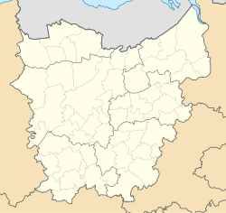
Sint-Denijs-Westrem is located in East Flanders
Sint-Denijs-Westrem
Sint-Denijs-Westrem
Coordinates: 51°01′17″N 3°40′08″E / 51.02139°N 3.66889°E / 51.02139; 3.66889
Country Belgium
Community Flemish Community
Region Flemish Region
Province East Flanders
ArrondissementGhent
MunicipalityGhent
Area
 • Total6.24 km2 (2.41 sq mi)
Population
 (2020-01-01)
 • Total5,545
 • Density890/km2 (2,300/sq mi)
Postal codes
9051
Area codes09

Sint-Denijs-Westrem (Dutch pronunciation: [ˌsɪndəˈnɛi̯sˈʋɛstrəm]; French: Saint-Denis-Westrem) is a sub-municipality of the city of Ghent located in the province of East Flanders, Flemish Region, Belgium. It was a separate municipality until 1977. On 1 January 1977, it was merged into Ghent.[1]

History

Sint-Denijs-Westrem lies on the Roman road between Kortrijk and Ghent. Archeological digs on the Flanders Expo site have shown significant signs of settlement from prehistory through the Middle Ages.[2]

During the late Middle Ages the castles of Idewalle, Borluut, Darupt, Hof ten Broecke, Maaltekasteel were built in and around the Sint-Denijs-Westrem area.

In 1858, architect, artisan and designer Jean-Baptiste Bethune moved his studio from Bruges to Sint-Denijs-Westrem.[3]

The town square ("Gemeenteplein") was built between 1895 and 1899.

Until the 20th century the area was mainly agrarian and sparsely populated; from the second half of the 20th century on the village has been steadily more densely built up, with many castle grounds subdivided for housing development.

References

  1. ^ "LISTE ALPHABETIQUE DES COMMUNES - Fusions de 1963 à 1977" (PDF).
  2. ^ Geschiedenis van Afsnee en Sint-Denijs-Westrem Accessed June 6, 2008.
  3. ^ "J.B. Bethune", De Stichting de Bethune

External links

This page was last edited on 26 June 2024, at 09:51
Basis of this page is in Wikipedia. Text is available under the CC BY-SA 3.0 Unported License. Non-text media are available under their specified licenses. Wikipedia® is a registered trademark of the Wikimedia Foundation, Inc. WIKI 2 is an independent company and has no affiliation with Wikimedia Foundation.