

Sinbaungwe Township or Tantabin Township (Burmese: ဆင်ပေါင်ဝဲမြို့နယ်) is a township of Thayet District in the Magway Region of Burma (Myanmar). It is located to the west of the Pegu Range in the foothills and on the plain of the Irrawaddy. Most of the township is east of the Irrawaddy, but about 20% of the township lies on the right (west) bank. The major town and administrative center is Sinbaungwe (Tantabin).
History
Sinbaungwe Township was formerly called Myedé Kyan (remnant of Myedé) as it had been part of Myedé Township (now Aunglan Township) before that was divided.[1] In 2008, a local student named Htoo Zaw Naing became the first student in the township's history to garner 5 distinctions on the National Matriculation Examination.[2]
Bounds
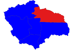
Sinbaungwe Township is bordered[3] by the following townships:
- Magway to the north,
- Taungdwingyi to the north and northeast,
- Lewe of Mandalay Region to the east
- Aunglan (Myayde) to the south,
- Thayet to the southwest, and
- Minhla to the west and northwest.
Villages
Among the many villages and wards (village census tracts) in Sinbaungwe Township are Baingyagon, Bwetsan, Chaungkauk, Egayit, Ingya, Inyon, Konbo, Kyauk-o, Kyigon, Thazi, Wundet, Yebok and Zaunggyandaung.
Economy
Rice growing is the main economic activity in the township.
Notes
- ^ Scott, James George and Hardiman, John Percy (1900) Gazetteer of Upper Burma and the Shan States Part 1, Volume 2, page 517
- ^ "ပညာဒါနကုသိုလ်ပြုလိုသူ စေတနာရှင်များသို့ ပန်ကြားလွှာ". Snapshot News. Retrieved 4 March 2012.
- ^ "Myanmar States/Divisions & Townships Overview Map" Myanmar Information Management Unit (MIMU)
External links
Capital: Magway | ||
| Gangaw District |
|   |
| Magway District | ||
| Minbu District | ||
| Pakokku District | ||
| Thayet District | ||
| Main cities and towns | ||
This Magway Region location article is a stub. You can help Wikipedia by expanding it. |