
Sarysu | |
|---|---|
District | |
| Сарысу ауданы | |
 Location of Sarysu District in Kazakhstan | |
| Country | |
| Region | Jambyl Region |
| Administrative center | Janatas |
| Government | |
| • Akim | Saken Mamytov[1] |
| Population (2013) | |
| • Total | 42,879 |
| Time zone | UTC+6 (East) |
Sarysu (Kazakh: Сарысу ауданы, Sarysu audany) is a district of Jambyl Region in south-eastern Kazakhstan. The administrative center of the district is the town of Janatas.[2] It
Geography
The district is named after the Sarysu River. Parts of it are in the lower basin of the Chu river, at the edge of the Moiynkum Desert. Lakes Ulken Kamkaly and Sorkol are located in the district.[3][4]
References
- ^ "Сакен Мамытов назначен акимом Сарысуского района Жамбылской области". www.inform.kz (in Russian). 2023-06-19.
- ^ www.geonames.de Subdivisions of Kazakhstan in local languages
- ^ "L-42 Topographic Chart (in Russian)". Retrieved 23 January 2023.
- ^ Google Earth.
External links
 Media related to Sarysu District at Wikimedia Commons
Capital: Taraz | ||
| Districts | 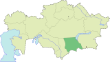 | |
| Major cities | ||
45°24′00″N 70°15′36″E / 45.40000°N 70.26000°E
This Kazakhstan location article is a stub. You can help Wikipedia by expanding it. |