
Saruhanlı | |
|---|---|
District and municipality | |
 Map showing Saruhanlı District in Manisa Province | |
 Saruhanlı Location in Turkey  Saruhanlı Saruhanlı (Turkey Aegean) | |
| Coordinates: 38°44′03″N 27°33′57″E / 38.73417°N 27.56583°E | |
| Country | Turkey |
| Province | Manisa |
| Government | |
| • Mayor | Zeki Bilgin (CHP) |
| Area | 771 km2 (298 sq mi) |
| Elevation | 32 m (105 ft) |
| Population (2022)[1] | 56,523 |
| • Density | 73/km2 (190/sq mi) |
| Time zone | TRT (UTC+3) |
| Area code | 0236 |
| Website | www |
Saruhanlı is a municipality and district of Manisa Province, Turkey.[2] Its area is 771 km2,[3] and its population is 56,523 (2022).[1] The town lies at an elevation of 32 m (105 ft).[4]
YouTube Encyclopedic
-
1/1Views:7 535
-
Manisa Saruhanlı Tanıtımı
Transcription
Agriculture
Olive, walnut and almond cultivation is among the important agricultural activities of Saruhanlı.[5]
Composition
There are 50 neighbourhoods in Saruhanlı District:[6]
- Adiloba
- Alibeyli
- Apak
- Atatürk
- Aydınlar
- Azimli
- Bahadır
- Bedeller
- Büyükbelen
- Çakmaklı
- Çaltepe
- Çamlıyurt
- Cengiz Topel
- Çerkez Osmaniye
- Çınaroba
- Çullugörece
- Cumhuriyet
- Develi
- Dilek
- Gökçeköy
- Gözlet
- Gümülceli
- Hacımusa
- Hacırahmanlı
- Halitpaşa
- Hatipler
- Heybeli
- İshakçelebi
- İstasyon
- Kayışlar
- Kemiklidere
- Kepenekli
- Koldere
- Koyuncu
- Kumkuyucak
- Kurtuluş
- Lütfiye
- Mütevelli
- Nuriye
- Paşa
- Pınarbaşı
- Sarıçam
- Sarısığırlı
- Saruhan
- Şatırlar
- Şehitler
- Seyitoba
- Taşdibi
- Tirkeş
- Yılmaz
References
- ^ a b "Address-based population registration system (ADNKS) results dated 31 December 2022, Favorite Reports" (XLS). TÜİK. Retrieved 12 July 2023.
- ^ Büyükşehir İlçe Belediyesi, Turkey Civil Administration Departments Inventory. Retrieved 12 July 2023.
- ^ "İl ve İlçe Yüz ölçümleri". General Directorate of Mapping. Retrieved 12 July 2023.
- ^ Falling Rain Genomics, Inc. "Geographical information on Saruhanlı, Turkey". Archived from the original on 2012-11-02.
- ^ Gazete, Banka (21 November 2021). "Manisalı üreticilere fidan desteği devam ediyor". Gazete Banka. p. https://gazetebanka.com/. Retrieved 21 November 2021.
- ^ Mahalle, Turkey Civil Administration Departments Inventory. Retrieved 19 September 2023.
External links
Saruhanlı in Manisa Province of Turkey | |||||||||||||||||||||||||||
|---|---|---|---|---|---|---|---|---|---|---|---|---|---|---|---|---|---|---|---|---|---|---|---|---|---|---|---|
| Districts |  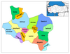 | ||||||||||||||||||||||||||
|
Metropolitan municipalities are bolded. | |||||||||||||||||||||||||||
This article about an Aegean Region of Turkey location is a stub. You can help Wikipedia by expanding it. |