
Sai Ngam
ไทรงาม | |
|---|---|
 District office, Sai Ngam District, Kamphaeng Phet Province, Thailand. | |
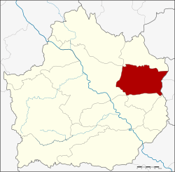 District location in Kamphaeng Phet province | |
| Coordinates: 16°28′20″N 99°53′48″E / 16.47222°N 99.89667°E | |
| Country | Thailand |
| Province | Kamphaeng Phet |
| Seat | Sai Ngam |
| Area | |
| • Total | 448.9 km2 (173.3 sq mi) |
| Population (2005) | |
| • Total | 51,183 |
| • Density | 114.0/km2 (295/sq mi) |
| Time zone | UTC+7 (ICT) |
| Postal code | 62150 |
| Geocode | 6202 |
Sai Ngam (Thai: ไทรงาม, pronounced [sāj ŋāːm]) is a district (amphoe) in the eastern part of Kamphaeng Phet province, central Thailand.
Geography
Neighboring districts are (from the south clockwise) Sai Thong Watthana, Mueang Kamphaeng Phet, Phran Kratai, Lan Krabue of Kamphaeng Phet Province, Wachirabarami and Sam Ngam of Phichit province.
History
The minor district (king amphoe) Sai Ngam was created on 15 May 1975, when the two tambons Sai Ngam and Nong Khla were split off from Mueang Kamphaeng Phet district.[1] It was upgraded to a full district on 25 March 1979.[2]
Administration
The district is divided into seven sub-districts (tambons), which are further subdivided into 72 villages (mubans). Sai Ngam is a township (thesaban tambon) and covers parts of tambon Sai Ngam. There are a further seven tambon administrative organizations (TAO).
| No. | Name | Thai name | Villages | Pop. | |
|---|---|---|---|---|---|
| 1. | Sai Ngam | ไทรงาม | 10 | 9,098 | |
| 2. | Nong Khla | หนองคล้า | 8 | 5,279 | |
| 3. | Nong Thong | หนองทอง | 11 | 6,746 | |
| 4. | Nong Mai Kong | หนองไม้กอง | 10 | 6,860 | |
| 5. | Maha Chai | มหาชัย | 12 | 7,317 | |
| 6. | Phan Thong | พานทอง | 10 | 7,917 | |
| 7. | Nong Mae Taeng | หนองแม่แตง | 11 | 7,966 |
References
- ^ ประกาศกระทรวงมหาดไทย เรื่อง แบ่งท้องที่อำเภอเมืองกำแพงเพชร จังหวัดกำแพงเพชร ตั้งเป็นกิ่งอำเภอไทรงาม (PDF). Royal Gazette (in Thai). 92 (98 ง): 1249. May 20, 1975. Archived from the original (PDF) on March 9, 2012.
- ^ พระราชกฤษฎีกาตั้งอำเภอหนองกุงศรี อำเภอไทรงาม อำเภอบ้านฝาง อำเภออุบลรัตน์ อำเภอเวียงชัย อำเภอดอยเต่า อำเภอนิคมคำสร้อย อำเภอนาหว้า อำเภอเสิงสาง อำเภอศรีสาคร อำเภอบึงสามพัน อำเภอนาดูน อำเภอค้อวัง อำเภอโพธิ์ชัย อำเภอเมืองสรวง อำเภอปลวกแดง อำเภอยางชุมน้อย อำเภอกาบเชิง อำเภอสุวรรณคูหา และอำเภอกุดข้าวปุ้น พ.ศ. ๒๕๒๒ (PDF). Royal Gazette (in Thai). 96 (42 ก Special): 19–24. March 25, 1979. Archived from the original (PDF) on September 30, 2007.
External links
This Kamphaeng Phet Province location article is a stub. You can help Wikipedia by expanding it. |