To install click the Add extension button. That's it.

The source code for the WIKI 2 extension is being checked by specialists of the Mozilla Foundation, Google, and Apple. You could also do it yourself at any point in time.

4,5
Kelly Slayton
Congratulations on this excellent venture… what a great idea!
Alexander Grigorievskiy
I use WIKI 2 every day and almost forgot how the original Wikipedia looks like.
Live Statistics
English Articles
Improved in 24 Hours
Added in 24 Hours
Languages
Recent
Show all languages
What we do. Every page goes through several hundred of perfecting techniques; in live mode. Quite the same Wikipedia. Just better.
.
Leo
Newton
Brights
Milds

S111 (Amsterdam)

From Wikipedia, the free encyclopedia

City route 111
Stadsroute 111
Major junctions
South end E35 / A 2 / A 9 – Amsterdam
North end S 112 – Amsterdam
Location
CountryKingdom of the Netherlands
Constituent countryNetherlands
ProvincesNorth Holland
MunicipalitiesAmsterdam, Ouder-Amstel
Highway system

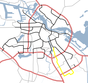
S111 is a Dutch road in Amsterdam. S111 is roughly 4 miles (6.4 kilometers) and is connected to S112. The S111 connects the Julianaplein (in front of the Amstel station) and the S112 with the A10, Villa Arena ( a shopping center) in the Bijlmermeer and the A9. Next, the road makes a loop past the Academic Medical Center, and once again connects to the A9. The road is sequentially called Julianaplein, Overzichtweg, Spaklerweg, Holterbergweg, Muntbergweg and Meibergdreef.

See also

Notes

[1] Map


  1. ^ "s111". Google Maps. Google LLC.
This page was last edited on 7 November 2022, at 21:01
Basis of this page is in Wikipedia. Text is available under the CC BY-SA 3.0 Unported License. Non-text media are available under their specified licenses. Wikipedia® is a registered trademark of the Wikimedia Foundation, Inc. WIKI 2 is an independent company and has no affiliation with Wikimedia Foundation.