
Sárrétudvari | |
|---|---|
Large village | |
 Coat of arms | |
| Country | |
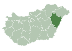
| County | Hajdú-Bihar |
| District | Püspökladány |
| Area | |
| • Total | 54.42 km2 (21.01 sq mi) |
| Population (2015) | |
| • Total | 2,963[1] |
| • Density | 54.5/km2 (141/sq mi) |
| Time zone | UTC+1 (CET) |
| • Summer (DST) | UTC+2 (CEST) |
| Postal code | 4171 |
| Area code | (+36) 54 |
Sárrétudvari is a village in Hajdú-Bihar county, in the Northern Great Plain region of eastern Hungary.
YouTube Encyclopedic
-
1/3Views:9391 3052 127
-
Sárrétudvari hírek - Diákok gondolatai a falon
-
Sárrétudvari Farsang 2013. - 5.a
-
Sárrétudvari Farsang 2013. Tánc - 5.b osztály
Transcription
Geography
It covers an area of 54.42 km2 (21 sq mi) and has a population of 2963 people (2015).[1]
Sport
References
- ^ a b Gazetteer of Hungary, 1 January 2015. Hungarian Central Statistical Office. 3 September 2015
External links
![]() Media related to Sárrétudvari at Wikimedia Commons
Media related to Sárrétudvari at Wikimedia Commons
- Official website in Hungarian
| Towns (2) |
| |
|---|---|---|
| Large villages (3) | ||
| Villages (7) | ||
| City with county rights |
|   |
|---|---|---|
| Towns | ||
| Large villages | ||
| Villages |
| |
| Other topics |
| |
47°14′N 21°12′E / 47.233°N 21.200°E
| International | |
|---|---|
| National | |
This Hajdú-Bihar location article is a stub. You can help Wikipedia by expanding it. |