
| Rassokha Рассоха | |
|---|---|
 Mouth location in Yakutia, Russia | |
| Location | |
| Country | Russia |
| Location | Yakutia |
| Physical characteristics | |
| Source | |
| • location | Lake Suokurdakh |
| • coordinates | 69°1′42″N 151°43′55″E / 69.02833°N 151.73194°E |
| • elevation | 100 m (330 ft) |
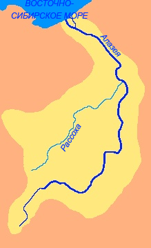
| Mouth | Alazeya |
• coordinates | 69°30′38″N 155°3′9″E / 69.51056°N 155.05250°E |
• elevation | 6 m (20 ft) |
| Length | 786 km (488 mi) |
| Basin size | 27,300 km2 (10,500 sq mi) |
| Discharge | |
| • average | 38 m3/s (1,300 cu ft/s) |
| Basin features | |
| Progression | Alazeya→ East Siberian Sea |
The Rassokha (Russian: Рассоха,[1] also Россоха; Yakut: Рассоха) is a river in the northeastern part of Yakutia, Russia. It is the major tributary of the Alazeya.[2]
YouTube Encyclopedic
-
1/3Views:21 7422 351813
-
Chernobyl Exclusion Zone. Rossokha (Россоха). Once the largest vehicle graveyard.
-
Diorama "Witnesses of Chernobyl" Rassokha 1/72
-
ZIL-130 AC-40 Fire Truck 1/72 AVD models
Transcription
Geography
The river is 786 kilometres (488 mi) long. The area of its basin is 27,300 square kilometres (10,500 sq mi).[3]
The Rassokha is formed by the confluence of the rivers Ilin-Yuryakh and Arga-Yuryakh in the Kolyma Lowland. The original sources of the uppermost river in the network are in the Ulakhan-Sis Range. The Rassokha flows across the Middle Kolyma District and the Lower Kolyma District in an area marked by permafrost, with numerous swamps and lakes. Finally it joins the left bank of the Alazeya 383 km (238 mi) from its mouth.[4]
The Rassokha has 145 tributaries that are longer than 10 km (6.2 mi) and in its basin there are 7,442 lakes with a total area of 3,240 km2 (1,250 sq mi).[4]
The river freezes in late September through early October and stays icebound until the end of May.
Fauna
The forest tundra of the Rassokha basin, together with the Kondakov Plateau and the Suor Uyata and the Ulakhan-Tas, is part of the migration corridor of the Sundrun reindeer population.[5]
 |
See also
References
- ^ Словарь названий гидрографических объектов России и других стран — членов СНГ, Federal Service for Geodesy and Cartography of Russia, 1999, p. 313
- ^ Google Earth
- ^ "Река Рассоха in the State Water Register of Russia". textual.ru (in Russian).
- ^ a b Rossokha - Water (in Russian)
- ^ Ivan Sivtsev , The Sundrun population of wild reindeer, The Ninth North American Caribou Workshop, Kuujjuaq, Québec, Canada, .
This Sakha Republic location article is a stub. You can help Wikipedia by expanding it. |
This article related to a river in Russia is a stub. You can help Wikipedia by expanding it. |