
Rohr | |
|---|---|
 | |
 Coat of arms | |
Location of Rohr within Schmalkalden-Meiningen district 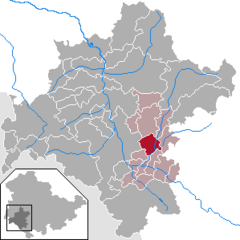 | |
 Rohr  Rohr | |
| Coordinates: 50°35′N 10°30′E / 50.583°N 10.500°E | |
| Country | Germany |
| State | Thuringia |
| District | Schmalkalden-Meiningen |
| Municipal assoc. | Dolmar-Salzbrücke |
| Government | |
| • Mayor (2022–28) | Siegmar Kleffel[1] (CDU) |
| Area | |
| • Total | 13.96 km2 (5.39 sq mi) |
| Elevation | 340 m (1,120 ft) |
| Population (2022-12-31)[2] | |
| • Total | 911 |
| • Density | 65/km2 (170/sq mi) |
| Time zone | UTC+01:00 (CET) |
| • Summer (DST) | UTC+02:00 (CEST) |
| Postal codes | 98530 |
| Dialling codes | 036844 |
| Vehicle registration | SM |
| Website | www.vg-dolmar.de |
Rohr is a municipality in the Schmalkalden-Meiningen district in Thuringia.
History
Rohr was first mentioned in 815. A Benedictine monastery was established in the 9th century and a Carolingian church, St. Michaels, was built. The monastery lasted for about 100 years but the church survives today. In 1206 a Benedictine convent was established outside of town. The convent was closely associated with the House of Henneberg and to a lesser degree with the Bibra family especially in the 14th century. Kloster Rohr was abandoned after reformation and is now a technical school. The shell of the former church was renovated into a modern building in the 2000s.
Population history
| Year | Population | Year | Population | Year | Population |
|---|---|---|---|---|---|
| 1994 | 986 | 1998 | 1,085 | 2002 | 1,062 |
| 1995 | 1,032 | 1999 | 1,084 | 2003 | 1,062 |
| 1996 | 1,050 | 2000 | 1,089 | 2004 | 1046 |
| 1997 | 1,080 | 2001 | 1,077 |
References
- ^ Gewählte Bürgermeister - aktuelle Landesübersicht, Freistaat Thüringen, accessed 10 November 2022.
- ^ "Bevölkerung der Gemeinden, erfüllenden Gemeinden und Verwaltungsgemeinschaften in Thüringen Gebietsstand: 31.12.2022" (in German). Thüringer Landesamt für Statistik. June 2023.
- WERNER WAGENHÖFER, Grablegen des Niederadels im Spätmittelalterlichen Franken - das Beispiel der Bibra, Wirtschaft - Gesellschaft - Mentalitäten im Mittelalter, Festschrift zum 75. Geburtstag von Rolf Sprandel, Franz Steiner Verlag, Stuttgart, 2006 ISBN 3-515-08882-2, ISBN 978-3-515-08882-4, Pages.335-359.
External links
- History of Rohr (in German)
- Kirchenburg Rohr
- Michaeliskirche in Rohr
- "Haselbrücke (historic stone arch bridge)". brueckenweb.de (in German).
- Kloster History (in German)
- BTZ Technical School at former Kloster Rohr
| Authority control databases: National |
|---|
This Schmalkalden-Meiningen location article is a stub. You can help Wikipedia by expanding it. |