
| Rennes Metro | |||
|---|---|---|---|
 | |||
| Overview | |||
| Native name | Métro de Rennes | ||
| Owner | Rennes Métropole | ||
| Locale | Rennes, Brittany, France | ||
| Transit type | Rubber-tyred metro | ||
| Number of lines | 2 | ||
| Number of stations | 28 | ||
| Daily ridership | Line A: 145,000 (2023) Line B: 80,000 (2023) | ||
| Annual ridership | 42.02 million (2022) | ||
| Headquarters | Rennes | ||
| Website | www | ||
| Operation | |||
| Began operation | 15 March 2002 | ||
| Operator(s) | Service des Transports en Commun de l'Agglomération Rennaise (STAR) | ||
| Number of vehicles | 55 | ||
| Technical | |||
| System length | 22.4 km (13.9 mi) | ||
| Track gauge | Rubber-tyred, no conventional track[1] | ||
| Average speed | 32 km/h (20 mph) | ||
| Top speed | 80 km/h (50 mph) | ||
| |||

The Rennes Metro (French: Métro de Rennes) (Breton: Metro Roazhon) is a light metro system serving the city of Rennes in Brittany, France. Opened on 19 March 2002, it made Rennes the smallest city in the world to have a metro system from 2002 to 2008.[2]
Currently the system contains two lines, Line A and B. It has 28 stations and stretches 23.5 kilometres (14.6 mi), with the majority of its route underground. Line A connects the quarter of Villejean to the quarter of Poterie, passing the city center. It is based on the Siemens VAL (véhicule automatique léger or light automatic vehicle in English) technology. In 2023, approximately 145,000 trips a day were made on Line A, and 80,000 on Line B.[3]
A second line, Line B, is opened on 20 September 2022.[4] Running north-east to south-west between Cesson-Sévigné and Saint-Jacques-de-la-Lande, it also has 15 stations, two of them interchangeable with Line A, forming an x-shaped network. It will be the first metro line in the world to use the NeoVal technology. Originally planned to open in 2020, the line suffered multiple delays, mainly due to the COVID-19 pandemic. After the opening of Line B, Rennes became the smallest city with two metro lines.
YouTube Encyclopedic
-
1/5Views:1 5196 4634 0711 32318 090
-
World Metro Systems: Rennes Metro
-
[ Video Metro ] RENNES MÉTRO - NOUVELLE LIGNE B - LE NOUVEAU MÉTRO EST LA !
-
Metro b Rennes - Saint-Germain
-
Metro Rennes Ligne a - Le Blosne
-
Metro, Rennes | French Public Transport
Transcription
History
During the 1960s, Henri Fréville (the Mayor of Rennes) discussed the return of the city's tramway which had been dissolved by the Mayor's predecessor, Yves Milon. However, the former tramway was disliked due to it being out of tune with the car-centric mentality of the city. When Charles de Gaulle visited Rennes on 31 March 1969, he remarked to Henri Fréville, "When you have a million inhabitants, you can have your metro."
The planning document underpinning urban transport structure (plan de déplacements urbains) in Rennes underwent a redesign which began in September 1984. This redesign was brought about by Mayor Edmond Hervé, who sought to ease congestion and reduce its future risk by remapping the city centre.
Between June and September 1986, SITCAR conducted the first studies considering the creation of a public transport system, separated from road traffic, for Rennes in response to the continued increases in passenger frequency. Several studies were to be conducted considering two different modes of transport: tramway and light railway.
- 1986: City Council decides to create a transport line on a north-western/south-eastern axis.
- 1989: The municipality decides to use VAL technology.
- 1992: The A Line project receives planning and environmental approvals.
- 1997: Beginning of work on Line A.
- 2002: Opening of Line A.
- 2005: Three park-and-ride lots were set up
- 2006: Creation of Korrigo card
- 2007: City Council decides to create a second metro line (B)
- 2010: The municipality decides to use CityVal technology.
- 2011: The B Line project receives planning and environmental approvals.
- 2014: Beginning of work on Line B
- 2022: Opening of Line B
| Station | Lige(s) | Inauguration Date [5] · [6] | Situation | District (Quartier) | |
|---|---|---|---|---|---|
| Anatole France | 
|
15 3 2002 | Deep Underground | Rennes (La Touche) | |
| Atalante | 
|
20 9 2022 | Overground | Cesson-Sévigné (Campagne Nord / Via Silva) | |
| Beaulieu - Université | 
|
20 9 2022 | Overground | Rennes (Beaulieu) | |
| Cesson - Viasilva | 
|
20 9 2022 | Overground | Cesson-Sévigné (Campagne Nord / Via Silva) | |
| Charles de Gaulle | 
|
15 3 2002 | Deep Underground | Rennes (Colombier - Champ-de-Mars) | |
| Clemenceau | 
|
15 3 2002 | Underground | Rennes (La Binquenais) | |
| Cleunay | 
|
20 9 2022 | Deep Underground | Rennes (Cleunay) | |
| Colombier | 
|
20 9 2022 | Deep Underground | Rennes (Colombier - Champ-de-Mars) | |
| Gares | 
|
Deep Underground | Rennes (Saint-Hélier) | ||
| Gros-Chêne | 
|
20 9 2022 | Deep Underground | Rennes (Maurepas) | |
| Henri Fréville | 
|
15 3 2002 | Underground | Rennes (Italie) | |
| Italie | 
|
15 3 2002 | Underground | Rennes (Italie) | |
| Jacques Cartier | 
|
15 3 2002 | Deep Underground | Rennes (Villeneuve) | |
| Joliot-Curie - Chateaubriand | 
|
20 9 2022 | Underground | Rennes (Longs-Champs, Jeanne d'Arc) | |
| J.F. Kennedy | 
|
15 3 2002 | Underground | Rennes (Villejean) | |
| Jules Ferry | 
|
20 9 2022 | Deep Underground | Rennes (Fougères - Sévigné) | |
| La Courrouze | 
|
20 9 2022 | Underground | Saint-Jacques-de-la-Lande (La Courrouze) | |
| La Poterie | 15 3 2002 | Overground | Rennes (Poterie) | ||
| Le Blosne | 
|
15 3 2002 | Underground | Rennes (Torigné) | |
| Les Gayeulles | 
|
20 9 2022 | Underground | Rennes (Maurepas) | |
| Mabilais | 
|
20 9 2022 | Deep Underground | Rennes (Arsenal-Redon) | |
| Pontchaillou | 
|
15 3 2002 | Overground | Rennes (Villejean) | |
| République | 
|
15 3 2002 | Deep Underground | Rennes (Centre-ville) | |
| Saint-Germain | 20 9 2022 | Deep Underground | Rennes (Centre-ville) | ||
| Saint-Jacques - Gaîté | 
|
20 9 2022 | Underground | Saint-Jacques-de-la-Lande (La Courrouze) | |
| Sainte-Anne | 
|
Deep Underground | Rennes (Centre-ville) | ||
| Triangle | 
|
15 3 2002 | Underground | Rennes (Torigné) | |
| Villejean - Université | 
|
15 3 2002 | Underground | Rennes (Villejean) | |
Line A
| Station | Line(s) | Inauguration | Situation | District | |||||
|---|---|---|---|---|---|---|---|---|---|
| J.F. Kennedy | (a) | 15 march 2002 | Underground | Rennes
(Villejean) | |||||
| Villjean-Université | (a) | 15 march 2002 | Underground | Rennes
(Villejean) | |||||
| Pontchaillou | (a) | 15 march 2002 | Overground | Rennes
(Villejean) | |||||
| Anatole France | (a) | 15 march 2002 | Deep Underground | Rennes
(La Touche) | |||||
| Sainte-Anne | (a)(b) | 15 march 2002 | Deep Underground | Rennes
(Centre-ville) | |||||
| République | (a) | 15 march 2002 | Deep Underground | Rennes
(Centre-ville) | |||||
| Charles de Gaulle | (a) | 15 march 2002 | Deep Underground | Rennes
(Colombier - Champ-de-Mars) | |||||
| Gares | (a)(b) (TER)(TGV) | 15 march 2002 | Deep Underground | Rennes
(Saint-Hélier) | |||||
| Jacques Cartier | (a) | 15 march 2002 | Deep Underground | Rennes
(Villeneuve) | |||||
| Clemenceau | (a) | 15 march 2002 | Underground | Rennes
(La Binquenais) | |||||
| Henri Fréville | (a) | 15 march 2002 | Underground | Rennes
(Italie) | |||||
| Italie | (a) | 15 march 2002 | Underground | Rennes
(Italie) |
Triangle | (a) | 15 march 2002 | Underground | Rennes
(Torigné) |
| Le Blosne | (a) | 15 march 2002 | Underground | Rennes
(Torigné) | |||||
| La Poterie | (a) | 15 march 2002 | Overground | Rennes
(Poterie) |

Opened on 15 March 2002, Line A is based on the Siemens VAL (véhicule automatique léger or light automatic vehicle) technology. The 9.4-kilometre (5.8 mi) Line A runs roughly northwest to southeast from J.F. Kennedy to La Poterie via Gare de Rennes (served by Gares metro station), with fifteen stations (thirteen of which are underground).
Services run between 05:20 and 00:40 each day (except Thursday, Friday and Saturday between 05:20 and 01:35), and with a waiting time of approximately 80 seconds between trains. From end to end, it takes around 16 minutes, with an average train speed of 32 km/h (20 mph). All stations are equipped with platform screen doors and lifts.
The system has 30 trains, each weighing 28 tonnes (27.6 long tons; 30.9 short tons) and 26 metres (85 ft 3+5⁄8 in) long, with a capacity of 170 passengers.
In January 2005, three park-and-ride lots were set up, offering 900 places to motorists. Two more opened in 2006–2007, able to accommodate an additional 700 vehicles.
On 1 March 2006, a card called KorriGo was created as a supplement to the ticket system to improve the metro traffic and the city's bus network.
The line is maintained by Service des Transports en Commun de l'Agglomération Rennaise (STAR), and managed by Keolis. It has a staff of approximately 100. It is operated from a control centre (poste de commande centralisée) situated in Chantepie. 120 cameras monitor the stations.
The station at La Poterie and viaducts on the line were designed by Foster + Partners.
With a population of just 205,000 inhabitants for city proper (in 2002), Rennes was the smallest city in the world to boast a metro until 2008 (when Lausanne Metro opened). However in 2013, 425,000 people (211 000 in Rennes) are served by the network in 43 municipalities. On average, there are 135,000 metro trips each day; this figure is expected to rise to 180,000 in coming years, leading to possible gridlock during the rush hours.
Stations
The station names have been chosen for the nearest existing streets or for points of interest near the station locations.
- J.F. Kennedy (former US President)
- Villejean-Université: University of Rennes 1 and University of Rennes 2
- Pontchaillou (elevated): Teaching hospital
- Anatole France (French poet and journalist)
- Sainte-Anne (French queen and Duchess of Brittany): city-center
- République: city-center
- Charles de Gaulle (former French President): city-center
- Gares (SNCF interchange): city-center
- Jacques Cartier (French navigator and explorer)
- Clemenceau (World War I French Prime Minister)
- Henri Fréville (former mayor of Rennes)
- Italie
- Triangle
- Blosne
- La Poterie (elevated)
Station signage is in French and Gallo at Charles de Gaulle station and French and Breton at Gares station.
Gallery
-
 An elevated section of Metro
 -
 The subsurface station, Sainte-Anne Quais
 -
 République station
 -
 République station
 -
 Kennedy station
 -
 Charles de Gaulle station
 -
 Pontchaillou station
Line B
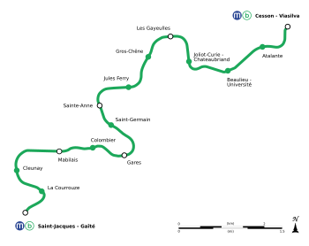

Opened on 20 September 2022, Line B is based on the new NeoVal technology. The line runs 13.4 kilometres (8.3 mi) north-east to south-west between Cesson - Viasilva and Saint-Jacques - Gaîté with 15 stations (12 of which underground). The line is interchangeable with Line A at two stations, Sainte-Anne and Gare, and other two stations, Saint-Germain and Colombier, are within walking distance to Line A.
The two terminal stations, Saint-Jacques - Gaîté and Cesson - Viasilva, as well as Les Gayeulles are served by the Parc relais (ride-and-park service) operated by STAR.
The north-eastern end of the line is served via a viaduct nearly 2.4 kilometres (1.5 mi) long. The viaduct is held up by 70 piers, with its average height between the bottom of its deck and the ground 6 to 7 metres (19 ft 8 in to 23 ft 0 in), and the tallest pier 9.35 metres (30 ft 8 in) tall.[7] The viaduct serves three stations: Cesson - Viasilva, Atlante, and Beaulieu - Université. At the end of the viaduct on the "Beaulieu - Université" station side, the line goes underground via an opening on the ground next to the parking lots of the university residence.
With the new line about to be open, the operator of Rennes' public transport system, Service des Transports en Commun de l'Agglomération Rennaise (STAR) have announced changes for the bus network,[8] scheduled to take effect on 24 October, a month after the opening of Line B. In addition, the bus line C3, currently having the same shade of green as the future Line B, will change its colour to yellow.
To promote the newly opening line, STAR announced that the entire Line B will be free on the first week of its operation, until Sunday 25 September. In addition, there will also be various celebration activities held at 5 stations: Saint-Jacques - Gaîté, La Courrouze, Cleunay, Gros-Chêne, and Cesson - Viasilva, as well as exhibitions of the new metro at Sainte-Anne station.[9]
On the day of opening, both lines of the metro network saw record-breaking daily ridership, with 155,000 riderships on Line A and 120,000 riderships on Line B, and an estimated 10% of the riderships transferring between the two lines. The two transfer stations, "Sainte-Anne" and "Gares", also saw the highest daily ridership of 23,000 and 15,000. The operator STAR have expected a daily ridership of 110,000 in the long term.[10]
Stations
- Saint-Jacques - Gaîté
- La Courrouze
- Cleunay
- Mabilais (4th tallest building in Rennes, Le Mabilay)
- Colombier: city-center
- Gares : city-center
- Saint-Germain (Saint-Germain Church): city-center
- Sainte-Anne: city-center
- Jules Ferry (French statesman and republican philosopher)
- Gros-Chêne
- Les Gayeulles (Park of Gayeulles)
- Joliot-Curie - Chateaubriand (lycée Joliot-Curie and lycée Chateaubriand)
- Beaulieu - Université (University of Rennes 1, Institut national des sciences appliquées de Rennes, and École nationale supérieure de chimie de Rennes)
- Atalante (technopole of Rennes Atlante)
- Cesson - Viasilva
See also
References
- ^ "Documentation technique du VAL 206 [dont le VAL 208 en est l'évolution]" (PDF). traction-electrique.ch (in French). Retrieved 7 February 2023.
- ^ "Metro of Rennes". mapa-metro.com. Retrieved 12 November 2023.
- ^ "À Rennes, une hausse de 20 % de la fréquentation des transports en commun depuis la ligne de métro B". Ouest France. Retrieved 12 November 2023.
- ^ "La date de la mise en service de la ligne b dévoilée !". metro-rennes-metropole.fr (in French). Retrieved 2022-07-18.
- ^ Laurent Fouillé (18 October 2012). "« Comment s'évalue un « bon TCSP » ? Demande à celui qui l'a fait ! » Le VAL de Rennes et son évaluation". rge.revues.org. Revue Géographique de l'Est. Retrieved 12 October 2016..
- ^ "La ligne B du métro de Rennes entrera bien en service le 20 septembre". letelegramme.fr. 24 August 2022. Retrieved 27 August 2022.
- ^ "Plaquette Viaduc Aout 2017" (PDF). metro-rennes-metropole.fr (in French). Retrieved 2022-07-18.
- ^ "Avant/Après : l'évolution du réseau". star2022.fr (in French). Retrieved 2022-08-06.
- ^ "Bienvenue sur la ligne b !". star2022.fr (in French). Retrieved 2022-09-16.
- ^ "Rennes. Avec 120 000 voyages, la fréquentation de la ligne B du métro atteint déjà des sommets". ouest-france.fr (in French). 2022-09-21.
External links
- STAR – official website (in French)
- STAR – new metro, new network (in French)
- Official website for the Line B project (in French)
- Map of Rennes Métro (in French) (in French)
- Rennes at UrbanRail.net (in English)
Rapid transit in Europe | |
|---|---|
| ** | |
| ** | |
| ** | |
| * | |
| * | |
* Only rapid transit systems in the European parts of Russia and Turkey are shown. For others, see Rapid transit in Asia.
** Armenia, Azerbaijan and Georgia are considered trans-continental countries and are also included in Rapid transit in Asia. *** Under construction. | |