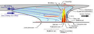
The rear-inflow jet is a component of bow echoes in a mesoscale convective system that aids in creating a stronger cold pool and downdraft. The jet forms as a response to a convective circulation having upshear tilt and horizontal pressure gradients. The cold pool that comes from the outflow of a storm forms an area of high pressure at the surface. In response to the surface high and warmer temperatures aloft due to convection, a mid-level mesolow forms behind the leading edge of the storm.
With a mid-level area of low pressure, air is drawn in under the trailing stratiform region of precipitation. As air is drawn in on the rear side of the storm, it begins to descend as it approaches the front line of the cells. Before reaching the leading edge, the jet descends to the surface as a strong downdraft, creating straight-line winds.[1]
Any mature mesoscale convective system is capable of developing its own rear-inflow jet, but questions remain as to what influences the strength of the jet. While the diabatic effects of sublimation, melting and evaporation play a role in influencing jet strength, these effects do not account for cases with strong rear-inflow jets. However, the diabatic effects are responsible for the jet subsiding behind the leading edge of the MCS.[2][3] The sinking of the jet first starts when the mid level inflow goes under the trailing stratiform cloud before descending to the melting layer.[4]
There are other factors that contribute to the strength of any rear inflow jet. The strength of a rear inflow jet can be greatly increased with induced vortices at the end of the line, called "line-end vortices" or "book-end vortices." These vortices at either end of the line will help reinforce the rear inflow towards the center of the line. The other factor that can help strengthen the jet is an environment in which the large scale flow is feeding/forcing mid-level air into the rear end of the storm.[5]
YouTube Encyclopedic
-
1/3Views:23 046249 956860
-
Understanding How Supercells Cycle
-
Storm Spotting Secrets
-
Features of a supercell storm, an exercize for meteorology and weather knowledge
Transcription
See also

References
- ^ Houze, Robert A. Jr. (31 December 2004). "Mesoscale convective systems" (PDF). Reviews of Geophysics. 42 (4): RG4003. Bibcode:2004RvGeo..42.4003H. doi:10.1029/2004RG000150. S2CID 53409251. Retrieved 10 July 2012.[permanent dead link]
- ^ Chong, Michel; Amayenc, Paul; Scialom, Georges; Testud, Jacques (1 March 1987). "A Tropical Squall Line Observed during the COPT 81 Experiment in West Africa. Part 1: Kinematic Structure Inferred from Dual-Doppler Radar Data". Monthly Weather Review. 115 (3): 670–694. Bibcode:1987MWRv..115..670C. doi:10.1175/1520-0493(1987)115<0670:ATSLOD>2.0.CO;2.
- ^ Klimowski, Brian A. (1 May 1994). "Initiation and Development of Rear Inflow within the 28-29 June 1989 North Dakota Mesoconvective System". Monthly Weather Review. 122 (5): 765–779. Bibcode:1994MWRv..122..765K. doi:10.1175/1520-0493(1994)122<0765:IADORI>2.0.CO;2.
- ^ Braun, Scott A.; Houze, Robert A. (1 April 1997). "The Evolution of the 10–11 June 1985 PRE-STORM Squall Line: Initiation, Development of Rear Inflow, and Dissipation". Monthly Weather Review. 125 (4): 478–504. Bibcode:1997MWRv..125..478B. doi:10.1175/1520-0493(1997)125<0478:TEOTJP>2.0.CO;2.
- ^ Skamarock, William C.; Weisman, Morris L.; Klemp, Joseph B. (1 September 1994). "Three-Dimensional Evolution of Simulated Long-Lived Squall Lines". Journal of the Atmospheric Sciences. 51 (17): 2563–2584. Bibcode:1994JAtS...51.2563S. doi:10.1175/1520-0469(1994)051<2563:TDEOSL>2.0.CO;2.
Further reading
- Jorgensen, Murphy and Wakimoto. "Rear Inflow Evolution in a Non-Severe Bow Echo Observed by Airborne Doppler Radar During Bamex."
- Houze and Smull. "Rear Inflow in Squall Lines with Trailing Stratiform Precipitation" American Meteorological Society, 1987.
- Harder, Jason. "Enhancement of the Downdraft" University of Wisconsin-Madison, 1998.
