
Ratchasan
ราชสาส์น | |
|---|---|
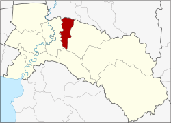 District location in Chachoengsao province | |
| Coordinates: 13°46′56″N 101°16′54″E / 13.78222°N 101.28167°E | |
| Country | Thailand |
| Province | Chachoengsao |
| Seat | Bang Kha |
| Area | |
| • Total | 134.9 km2 (52.1 sq mi) |
| Population (2017) | |
| • Total | 12,809 |
| • Density | 94.95/km2 (245.9/sq mi) |
| Time zone | UTC+7 (ICT) |
| Postal code | 24120 |
| Geocode | 2407 |
Ratchasan (Thai: ราชสาส์น, pronounced [râːt.t͡ɕʰā.sǎːn]) is a district (amphoe) in the central part of Chachoengsao province, central Thailand.
History
The area of Ratchasan was separated from Phanom Sarakham district and became a minor district (king amphoe) on 16 February 1977.[1] It was upgraded to a full district on 4 July 1994.[2]
Geography
Neighboring districts are (from the east clockwise): Phanom Sarakham, Plaeng Yao, and Bang Khla of Chachoengsao Province; and Ban Sang of Prachinburi province.
The important water resource is the Khlong Tha Lat.
Administration
Central administration
Ratchasan is divided into three sub-districts (tambons), which are further subdivided into 31 administrative villages (mubans).
| No. | Name | Thai | Villages | Pop.[3] |
|---|---|---|---|---|
| 1. | Bang Kha | บางคา | 6 | 2,132 |
| 2. | Mueang Mai | เมืองใหม่ | 9 | 3,146 |
| 3. | Dong Noi | ดงน้อย | 16 | 7,531 |
Local administration
There are three sub-district administrative organizations (SAO) in the district:
- Bang Kha (Thai: องค์การบริหารส่วนตำบลบางคา) consisting of sub-district Bang Kha.
- Mueang Mai (Thai: องค์การบริหารส่วนตำบลเมืองใหม่) consisting of sub-district Mueang Mai.
- Dong Noi (Thai: องค์การบริหารส่วนตำบลดงน้อย) consisting of sub-district Dong Noi.
References
- ^ ประกาศกระทรวงมหาดไทย เรื่อง แบ่งท้องที่อำเภอพนมสารคาม จังหวัดฉะเชิงเทรา ตั้งเป็นกิ่งอำเภอราชสาส์น (PDF). Royal Gazette (in Thai). 94 (13 ง): 773. February 22, 1977. Archived from the original (PDF) on January 26, 2009.
- ^ พระราชกฤษฎีกาตั้งอำเภอเปือยน้อย ... และอำเภอศรีวิไล พ.ศ. ๒๕๓๗ (PDF). Royal Gazette (in Thai). 111 (21 ก): 32–35. June 3, 1994. Archived from the original (PDF) on September 30, 2007.
- ^ "Population statistics 2017" (in Thai). Department of Provincial Administration. Retrieved 2018-04-04.
External links
This Chachoengsao Province location article is a stub. You can help Wikipedia by expanding it. |