
Rangsdorf | |
|---|---|
 Coat of arms | |
Location of Rangsdorf within Teltow-Fläming district 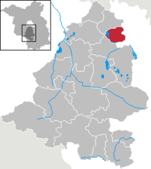 | |
 Rangsdorf  Rangsdorf | |
| Coordinates: 52°17′N 13°26′E / 52.283°N 13.433°E | |
| Country | Germany |
| State | Brandenburg |
| District | Teltow-Fläming |
| Subdivisions | 3 Ortsteile |
| Government | |
| • Mayor (2019–27) | Klaus Rocher[1] (FDP) |
| Area | |
| • Total | 33.72 km2 (13.02 sq mi) |
| Elevation | 36 m (118 ft) |
| Population (2021-12-31)[2] | |
| • Total | 11,540 |
| • Density | 340/km2 (890/sq mi) |
| Time zone | UTC+01:00 (CET) |
| • Summer (DST) | UTC+02:00 (CEST) |
| Postal codes | 15834 |
| Dialling codes | 033708 |
| Vehicle registration | TF |
| Website | www.rangsdorf.de |
Rangsdorf is a municipality in the district of Teltow-Fläming in Brandenburg in Germany. It has an airfield [up to 1940 a genuine commercial airport] from where on 20 July 1944 Claus Schenk Graf von Stauffenberg took off on his fateful attempt to assassinate German leader Adolf Hitler at his military headquarters in East Prussia, the Wolfsschanze.
YouTube Encyclopedic
-
1/5Views:4 4941 2381 3865524 371
-
💥ГСВГ. Гарнизон Рангсдорф (Rangsdorf). Германия. 2022
-
Trip to Rangsdorf and Wuehnsdorf south of Berlin 1994
-
Rangsdorf. Озеро ледникового периода, сельское очарование и граф фон Штауффенберг.
-
Rangsdorf Airfield
-
Fontane Gymnasium Rangsdorf | Imagefilm
Transcription
Demography
-
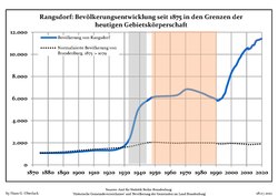
Development of Population since 1875 within Current Boundaries (Blue Line: Population; Dotted Line: Comparison to Population Development of Brandenburg state; Grey Background: Time of National Socialist rule; Red Background: Time of Communist rule)
-
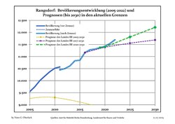
Recent Population Development and Projections (Population Development before Census 2011 (blue line); Recent Population Development according to the Census in Germany in 2011 (blue bordered line); Official projections for 2005-2030 (yellow line); for 2020-2030 (green line); for 2017-2030 (scarlet line)


|
|
|
References
- ^ Landkreis Teltow-Fläming Wahl der Bürgermeisterin / des Bürgermeisters, accessed 4 July 2021.
- ^ "Bevölkerungsentwicklung und Flächen der kreisfreien Städte, Landkreise und Gemeinden im Land Brandenburg 2021" (PDF). Amt für Statistik Berlin-Brandenburg (in German). June 2022.
- ^ Detailed data sources are to be found in the Wikimedia Commons.Population Projection Brandenburg at Wikimedia Commons
Towns and municipalities in Teltow-Fläming | ||
|---|---|---|
 | ||
| International | |
|---|---|
| National | |
| Geographic | |
This Brandenburg location article is a stub. You can help Wikipedia by expanding it. |