
| Raid on Oyster River | |||||||
|---|---|---|---|---|---|---|---|
| Part of King William's War | |||||||
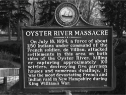 New Hampshire historical marker (number 50) in Durham[1] | |||||||
| |||||||
| Belligerents | |||||||
|
|
New France Wabanaki Confederacy (Abenaki, Maliseet) | ||||||
| Commanders and leaders | |||||||
|
Francis Drew Thomas Pickford John Woodman[2] |
Claude-Sébastien de Villieu Louis-Pierre Thury Bomazeen Captain Nathaniel[3] Assacumbuit | ||||||
| Strength | |||||||
| unknown | 250 Abenaki Indians | ||||||
| Casualties and losses | |||||||
| 104 inhabitants were killed and 27 taken captive | unknown | ||||||
The Raid on Oyster River (also known as the Oyster River Massacre) happened during King William's War, on July 18, 1694, at present-day Durham, New Hampshire.
YouTube Encyclopedic
-
1/1Views:717
-
Gettysburg: High Water Mark
Transcription
Historical context
Massachusetts responded to the Siege of Pemaquid (1689) by sending out 600 men to the border region. Led by Major Jeremiah Swaine of Reading, Massachusetts, the soldiers met on August 28, 1689, and then scoured the region. Despite Swaine's presence, the natives attacked Oyster River (Durham, New Hampshire) and killed 21 people, taking several others captive.[4] In 1693, the English at Boston had entered into peace and trade negotiations with the Abenaki tribes in eastern Massachusetts. The French at Quebec under Governor Frontenac wished to disrupt the negotiations and sent Claude-Sébastien de Villieu in the fall of 1693 into present-day Maine, with orders to "place himself at the head of the Acadian Indians and lead them against the English."[5] Villieu spent the winter at Fort Nashwaak. The Indian bands of the region were in general disagreement whether to attack the English or not, but after discussions by Villieu and the support of Father Louis-Pierre Thury and Father Vincent Bigot (at Pentagouet) they went on the offensive.
Raid
The English settlement of Oyster River was attacked by Villieu with about 250 Abenaki Indians, composed of two main groups from the Penobscot and Norridgewock under command of their sagamore Bomazeen (or Bomoseen). A number of Maliseet from Medoctec took part in the attack. The Indian force was divided into two groups to attack the settlement, which was laid out on both sides of the Oyster River. Villieu led the Pentagoet and the Meductic/Nashwaaks. The attack commenced at daybreak, with the small forts quickly falling to the attackers. In all, 104 inhabitants were killed and 27 taken captive,[6] with half the dwellings, including the garrisons, pillaged and burned to the ground. Crops were destroyed and livestock killed, causing famine and destitution for survivors.
Consequences
After the successful raid on Oyster River, Claude-Sébastien de Villieu joined Acadian Governor Joseph Robineau de Villebon as the commander of Fort Nashwaak, capital of Acadia.
See also
References
Endnotes
- ^ "List of Markers by Marker Number" (PDF). nh.gov. New Hampshire Division of Historical Resources. November 2, 2018. Retrieved July 5, 2019.
- ^ "The border wars of New England, commonly called King William's and Queen Anne's wars". 1897. p. 100. Retrieved 2014-09-13.
- ^ "The border wars of New England, commonly called King William's and Queen Anne's wars". 1897. p. 96. Retrieved 2014-09-13.
- ^ Drake p. 37-38
- ^ Webster, John Clarence. Acadia at the End of the Seventeenth Century. Saint John, NB, The New Brunswick Museum, 1979. p. 57.
- ^ Webster, John Clarence. Acadia at the End of the Seventeenth Century. Saint John, NB, The New Brunswick Museum, 1979. p. 65
Primary texts
- William L. Wolkovich - Valkavicius, "The Groton Indian Raid of 1694 and Lydia Longley", Historical Journal of Massachusetts Volume 30, No. 2 (Summer 2002)
- Acadia at the end of the 17th Century, p. 56
- A French account of the raid upon the New England frontier in 1694. Acadiensis. 1901
- Rev. John Pike, Journal of the Rev. John Pike, of Dover, N.H., ed. Rev. A.H. Quint (Cambridge: Press of John Wilson and Son, 1876)
- Jan K. Herman, "Massacre at Oyster River," New Hampshire Profiles, October 1976, 50.
- Francis Parkman, Count Frontenac and New France under Louis XIV, vol. 2 of France and England in North America (1877; reprint, New York: The Library of America, 1983)
- Jeremy Belknap, The History of New Hampshire, ed. John Farmer (Dover, N.H.: S.C. Stevens and Ela & Wadleigh, 1831)
- Thomas Hutchinson, The History of the Colony and Province of Massachusetts Bay (originally published 1764–1828; reprint, Cambridge: Harvard University Press, 1936), 2:55.
- Cotton Mather, Decennium Luctuosum (Boston, 1699); reprinted in Magnalia Christi Americana (London, 1702), 86.
- Everett S. Stackpole, History of New Hampshire (New York: The American Historical Society, 1926), 1:182.
- Samuel Adams Drake, The Border Wars of New England Commonly called King William's and Queen Anne's Wars (Williamstown, Mass: Corner House, 1973), 96.
- Jan K. Herman, "Massacre on the Northern New England Frontier, 1689–1694" (master's thesis, University of New Hampshire, 1966), 43.
- Kenneth M. Morrison, The Embattled Northeast (Berkeley: University of California Press, 1984), 128.
- John Clarence Webster, Acadia at the End of the Seventeenth Century. Saint John, NB, The New Brunswick Museum, 1979.
- The address of C. Alice Baker - History and Proceedings of the Pocumtuck Valley Memorial Association, Volume 4, p. 401
- Samuel Abbott Green, "Groton during the Indian Wars"; see: "King Williams War"
External links
43°07′59″N 70°55′26″W / 43.133°N 70.924°W