
| Puig des Racó | |
|---|---|
| Puig des Recò | |
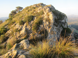 Puig des Racó: the summit | |
| Highest point | |
| Elevation | 386 m (1,266 ft) |
| Prominence | 170 m (560 ft)[1] |
| Coordinates | 39°42′41″N 3°23′28″E / 39.7113°N 3.3910°E |
| Geography | |
| Parent range | Serres de Llevant |
| Climbing | |
| First ascent | ancestral |
| Easiest route | footpath from Coll des Racó |


The Puig des Racó (or Puig des Recò[2]) is a hill in the northeast of the Spanish island of Mallorca.
Geography

The hill belongs to the Artà mountains, the northern part of the Serres de Llevant mountain range. Its summit reaches an elevation of 386 meters; a saddle at 371 m divides it from a subsummit marked by a trig point at an elevation of 385 m. The municipal boundary between Artà (West of the hill) and Capdepera (East) runs along its crest. Within the municipality of Capdepera, the Puig de Racó is the highest point. At the foot of its western flank runs the road from Artà to Cala Torta from south-west to north-east, while south of the hill runs the provincial road Ma-15 between Artà and Capdepera. Northwest of the Puig des Racó rises the Puig Poca Son, to which it is connected by the Coll des Racó saddle, at 233 m of elevation. Northeast the saddle named Coll de ses Buines (312 m) connects Puig des Racò with the Puig Poloni (363 m).[3] At the southwestern spur of the hill lies the archaeological site of Talaiot de ses Planetes. From the mountain spring some small streams which only occasionally carry water.[4]
Access to the summit
The NE subsummit of the hill can be easily reached following a good foothpath starting from the Colle des Racó; the main summit of the hill needs some scrambling[5] but no alpinistic skills.
See also
References
- ^ "Puig des Racó - also known as Puig des Recó". peakery.com. Retrieved 2022-03-10.
- ^ Bernd, DL2DXA (2019-05-15). "Die Insel der vielen unzugänglichen Berge" (in German). Retrieved 2022-03-10.
{{cite web}}: CS1 maint: numeric names: authors list (link) - ^ "Iberpix" (in Spanish). Instituto Geográfico Nacional. Retrieved 2022-03-10.
- ^ "Sa Font Grossa" (in Catalan). fontsdetramuntana.com. Retrieved 2022-03-11.
- ^ filippoceragioli (2022-03-08). "Puig des Racó - also known as Puig des Recó". peakery.com. Retrieved 2022-03-10.
Photo gallery
![]() Media related to Puig des Racó at Wikimedia Commons
Media related to Puig des Racó at Wikimedia Commons

