
| Carrawburgh | |
|---|---|
 Southern rampart of Brocolitia | |
 | |
| Alternative name(s) | Brocolitia, Procolita, or Brocolita |
| Place in the Roman world | |
| Province | Britannia |
| Stationed military units | |
| — Cohorts — | |
| I Aquitanorum, I Tungrorum, I Cugernorum, I Batavorum equitata, I Frisiavonum | |
| Location | |
| Coordinates | 55°02′10″N 2°13′23″W / 55.036°N 2.223°W |
| County | Northumberland |
| Country | England |
| Reference | |
| UK-OSNG reference | NY858712 |
| Site notes | |
| Controlled by | English Heritage |


Carrawburgh is a settlement in Northumberland.[1] In Roman times, it was the site of a 3+1⁄2-acre (1.5 ha) auxiliary fort on Hadrian's Wall called Brocolitia, Procolita, or Brocolita.
The name "Procolita" is found in the 5th-century document, the Notitia Dignitatum, and "Brocoliti" in the 7th-century Ravenna Cosmography. The name is probably based on the Celtic name for the place, and one possible translation put forward is 'badger holes'.
YouTube Encyclopedic
-
1/3Views:602331823
-
The Roman Cult of Mithras on Hadrian’s Wall (Rituals and Roman Britain)
-
The Temple of Mithras at Brocolitia - Hadrian's Wall: Iles Tours
-
The Temple Of Mithras
Transcription
Roman fort
Hadrian's Wall was built from 122 AD and most of the wall forts a few years later. Brocolitia was built a few years later still probably to fill a slightly longer gap between forts at Housesteads, 5.2 miles (8.4 km) away, and Chesters, 3.5 miles (5.6 km) away. This later date is evidenced by part of the Vallum being levelled before building the fort showing that it was an afterthought.[2] A date of 130 has been suggested[3] from a fragmentary inscription now in the Chesters Museum. The fort either used the Wall (narrow gauge on a broad base at this point) itself as its northern rampart, or was built parallel to it but detached. The fort was about a mile west of the Wall's northernmost point at Limestone Corner, and just over a mile west of the nearest milecastle, Milecastle 30.
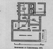
Only the fort's earthworks are now visible, the Wall at this point and the fort's north ramparts having been demolished for the construction of General Wade's early 18th-century military road (now the B6318). The late 19th-century archaeologist John Clayton carried out a partial excavation of the site, revealing a military bath-house outside the fort's west gate (in 1873) and the fort's south-west corner-tower (in 1876).
The Roman Inscriptions of Britain lists 48 inscriptions for the site. They show its garrisoning units to have been as follows:
- Cohors I Tungrorum[4] 122-138 AD, later at Housesteads
- Cohors I Aquitanorum[5] c. 133
- Cohors I Cugernorum, end 2nd century
- Cohors I Batavorum[6][7][8] 213-222, 237, and 400 respectively[9]
The First Cohort of Frisiavones are also attested at Brocolitia at some stage, as shown by an inscription on an altar stone, which tells us that Optio Maus had repaid a vow to the goddess Coventina. (This unit is also recorded as present at Ardotalia.[10]) Whether this altar was the repayment of the vow is unknown.
Vicus
The vicus (civilian settlement) was just outside the west side of the fort and covered about 4 hectares.[11]
Roman sanctuaries

The remains of three Roman sanctuaries have been discovered in the low-lying marshy ground beyond the fort's south-west corner. All three sites lie adjacent to a small tributary stream of Meggie's Dene Burn, which runs three miles from Carrawburgh to empty into the River South Tyne near Newbrough's fort on the Stanegate.
Nearest to the fort, about 80 metres (260 ft) from its south-west corner, are the remains of an early 3rd century mithraeum, i.e. a temple of the mystery cult of the Roman god Mithras. Discovered in 1949 and excavated by I.A. Richmond and J.P. Gillam in 1950, it is the second-most northernly mithraeum discovered so far – only Bremenium (High Rochester), more than 10 miles (16 km) from Brocolitia, is further north.[12]: 282 [13]: 77 The Brocolitia mithraeum is also the only sanctuary outside the Rhine provinces from which a monument of the goddess Vagdavercustis has been recovered. Like most other mithraea, the Brocolitia temple was built to resemble a cave, and also had the usual anteroom, and a nave with raised benches (podia) along the sides.
At Brocolitia, the anteroom and nave were separated by a wattle-work screen, the base of which was found exceptionally well preserved. Excavations revealed three stages of development:[12]: 292–293 the first stage was small, around 5.5 metres (18 ft) wide and 8 metres (26 ft) long.[13]: 79 The building was expanded to 11 metres (36 ft) in length in a second stage, at which time the temple also gained elaborate furnishings and extensive woodwork. This second stage existed for the entire 3rd century, and included at least two major renovations. The second stage was looted and the furnishings destroyed around 296–297 AD, but the sanctuary itself and the stone monuments remained intact, and the temple was re-equipped in a third stage shortly thereafter. The third stage includes three monuments by different cohort prefects, commanders of Cohors I Batavorum, a Roman Batavi unit of auxiliary cavalry stationed at Brocolitia.[13]: 79 All three date to the 3rd century.[13]: 79 The youngest coin found on the premises was a freshly-minted follis of Maximian (r. 296–308).[12]: 296 This coincides with the third structural period on Hadrian's Wall (297–367), but the complete lack of coins from after 308 suggests that the temple did not remain in use for much of the 4th century.[12]: 296 The temple was deliberately desecrated by the removal of the primary tauroctony scene, only a piece of which was found. Other than a collapsed roof, the temple was found almost exactly as the Romans had left it. The foundations of the temple are still visible, as are the wooden stakes on which the podia benches were raised. A reconstruction of the sanctuary is on display at the Great North Museum in Newcastle upon Tyne.
Directly in front of the entrance to the mithraeum the remains of an apse, well, and altar were found and named as the Shrine to the Nymphs and Genius Loci, sometimes referred to as a "nymphaeum". Found in 1957 and excavated in 1960, this was the least used temple at Carrawburgh. The Shrine may not have had a traditional building, rather it was a paved and an open air shrine. The altar, dedicated by M. Hispanius Modestinus c. AD 213, was inscribed identically on two sides, and stood on a pedestal indicating it was out in the open, and meant to be walked around.[14] It is likely that this shrine was built during a period of disuse of the Mithraeum as it was located so close to the Mithraic Temple. The building of the second Mithraeum reused materials from the Shrine to the Nymphs and Genius Loci, but preserved the altar. The shrine has a destruction layer around AD 300, roughly the same time as a destruction layer at the Temple to Mithras.[14]
The third site was 'Coventina's Well', a centre for worship of the Romano-British goddess Coventina. This sanctuary, discovered by Clayton in 1876, is the source of the stream. The well is known for the findings of over 13,000 coins, sculptural reliefs, and altars. It was built c.AD128-133, during the construction of the Vallum, in order to help control the water level of the area, it is likely after this it became associated with Coventina with the height of the cult being in the late 2nd to early 3rd centuries[15] when the Batavians were stationed at the fort.
No remains of the nymphaeum or well are now visible.
Ownership
Having been in private hands for many years, the fort, which is a scheduled monument,[16] was gifted to the nation in January 2020 by Jennifer Du Cane, whose family have owned the site since the 1950s. The fort is now in the ownership of Historic England and administered by English Heritage.[17]
References
- ^ Esmonde Cleary, A. "Places: 89128 (*Brocolitia)". Pleiades. Retrieved 28 July 2016.
- ^ Carrawburgh Roman Fort and Temple of Mithras https://www.english-heritage.org.uk/visit/places/temple-of-mithras-carrawburgh-hadrians-wall/history/
- ^ "Roman Britain – Brocolitia".
- ^ RIB 1563b
- ^ RIB 1550
- ^ RIB 1544
- ^ RIB 1553
- ^ Notitia Dignitarum
- ^ The latter is one of the few pieces of evidence for the governor Tuccianus, under the emperor Maximinus
- ^ Roman Britain – Ardotalia
- ^ Carrawburgh Roman Fort and Temple of Mithras https://www.english-heritage.org.uk/visit/places/temple-of-mithras-carrawburgh-hadrians-wall/history/
- ^ a b c d Vermaseren, M. J. (1956), Corpus Inscriptionum et Monumentorum Religionis Mithriacae, vol., I, The Hague: Nijhoff.
- ^ a b c d Clauss, Manfred (1992), Cultores Mithrae, Stuttgart: Steiner.
- ^ a b Smith, D.J (1962). "The Shrine of the Nymphs and the Genius Loci at Carrawburgh". Archaeologia Aeliana. Series 4, vol. 40: 59–81.
- ^ Allason-Jones, Lindsay (1985). Coventina's Well: A Shrine on Hadrian's Wall.
- ^ Historic England. "Carrawburgh Roman fort and Hadrian's Wall and vallum between the field boundary east of the fort and the field boundary west of Coventina's Well in wall mile 31 (1015914)". National Heritage List for England. Retrieved 9 January 2020.
- ^ "Hadrian's Wall Roman fort 'gifted to the nation'". BBC News. Retrieved 9 January 2020.
External links
- Brocolitia at http://roman-britain.co.uk/
- BROCOLITIA FORT on the line of Hadrian's Wall as it exists today
Forts and structures of Hadrian's Wall | ||
|---|---|---|
| Wall Forts (East to West) |   | |
| Outpost Forts | ||
| Stanegate Forts |
| |
| Supply Forts | ||
| Cumbrian Coast Forts (North to South) |
| |
| Milecastles | ||
| Milefortlets | ||
| Other structures on Hadrian's Wall | ||
| Regular and linear features | ||
| Authority control databases: Geographic |
|---|