
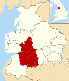
Central Lancashire is an area of Lancashire, England.
YouTube Encyclopedic
-
1/3Views:14 8954 30013 986
-
It’s all happening at UCLan in Preston – a great place to live and study
-
Study Medicine at The University of Central Lancashire (UCLan)
-
This is Preston
Transcription
Central Lancashire New Town
Central Lancashire New Town was the largest of the post-war English new towns, designated in 1970[1] and covering 35,255 acres (143 km2): the County Borough of Preston, parts of Chorley, Fulwood, Leyland, Walton-le-Dale, Chorley Rural District and Preston Rural District.[2]
Its Development Corporation, abolished in 1986, pioneered shared ownership housing (as introduced by the Housing Act 1980) and also witnessed the first transfer of social housing stock to registered Housing Associations following tenant consultation and ballots.
Central Lancashire planning area
Since 2008, Central Lancashire is an area of joint spatial planning covering the Lancashire districts of the City of Preston, the Borough of South Ribble and the Borough of Chorley, referring to the area covered by the three districts.[3] A joint Local Development Framework was adopted in 2012.
The officially estimated population in 2009 was 347,600.[citation needed]
Preston Built-up Area

The Office for National Statistics gives the 2011 population of the Preston Built-up Area, covering Preston, Leyland, Chorley, Bamber Bridge, Fulwood, Hutton, Longton, Adlington, Grimsargh and Euxton, as 313,322.[4] This area replaced the 2001 definition of Preston Urban Area which then had a population of 264,601.[5]
See also
- Sir Francis Pearson, former MP for Clitheroe, was Chairman of the Central Lancashire New Town Development Corporation from 1971.
- South Lancashire
References
- ^ "Central Lancashire". 17 March 2016. Archived from the original on 17 March 2016. Retrieved 11 December 2023.
- ^ London Gazette. 14 April 1970.
- ^ Preston, South Ribble, Chorley: Central Lancashire Archived 9 November 2010 at the Wayback Machine, retrieved 13 November 2011
- ^ "2011 Census - Built-up areas". ONS. Retrieved 1 July 2013.
- ^ (2004) "Census 2001: Key Statistics for urban areas in the North", Office for National Statistics, ISBN 0-11-621744-8 , Table KS01, p. 24. Retrieved 13 November 2011.
External links
53°42′36″N 2°38′35″W / 53.710°N 2.643°W
This Lancashire location article is a stub. You can help Wikipedia by expanding it. |