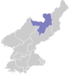
Poch'ŏn County
보천군 | |
|---|---|
| Korean transcription(s) | |
| • Chosŏn'gŭl | 보천군 |
| • Hancha | 普天郡 |
| • McCune–Reischauer | Poch'ŏn-gun |
| • Revised Romanization | Bocheon-gun |
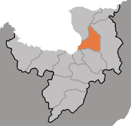 Map of Ryanggang showing the location of Pochon | |
| Country | North Korea |
| Province | Ryanggang |
| Administrative divisions | 1 ŭp, 2 workers' districts, 17 ri |
| Area | |
| • Total | 783 km2 (302 sq mi) |
| Population (2008[1]) | |
| • Total | 37,225 |
| • Density | 48/km2 (120/sq mi) |
Poch'ŏn County is a kun, or county, in Ryanggang Province, North Korea. It looks westward across the Amrok River at China.
Geography
The Masingryong Mountains pass through the county, which slopes downward gradually to the west. The county sits atop the Paektu Plateau, with the mountains rising to only a small relative height. The highest peak is Namp'ot'aesan (남포태산). There are numerous streams, of which the chief is the Karimch'ŏn. Some 83% of the county's area is taken up by forestland. The temperatures are quite cold.
Economy
The predominant local industry is logging. There are also deposits of magnetite, alunite, and obsidian. Poch'ŏn's farms produce potatoes, wheat and barley, among other crops; orchards and livestock farms are also found.
Transportation
Poch'ŏn is served by the Samjiyŏn and Poch'ŏn (Paektusan Rimch'ŏl) lines of the Korean State Railway, and also by roads.
Administrative divisions
Pochon-gun is divided into 1 up (town), 2 rodongjagu (workers' districts) and 17 ri (villages):
| Chosŏn'gŭl | Hancha | |
|---|---|---|
| Poch'ŏn-ŭp | 보천읍 | 普天邑 |
| Taejil-lodongjagu | 대진로동자구 | 大鎭勞動者區 |
| Taep'yŏng-rodongjagu | 대평로동자구 | 大坪勞動者區 |
| Ch'ŏngrim-ri | 청림리 | 靑林里 |
| Hosal-li | 호산리 | 虎山里 |
| Hŭngsŏng-ri | 흥성리 | 興成里 |
| Hwajŏl-li | 화전리 | 樺田里 |
| Kasal-li | 가산리 | 佳山里 |
| Mun'am-ri | 문암리 | 門岩里 |
| Naegong-ri | 내곡리 | 內曲里 |
| Paekcha-ri | 백자리 | 柏子里 |
| Pohŭng-ri | 보흥리 | 保興里 |
| Ryongdŏng-ri | 룡덕리 | 龍德里 |
| Sangryong-ri | 상룡리 | 上龍里 |
| Sinhŭng-ri | 신흥리 | 新興里 |
| Songbong-ri | 송봉리 | 松峰里 |
| Taehŭng-ri | 대흥리 | 大興里 |
| Taesil-li | 대신리 | 大新里 |
| Ŭihwa-ri | 의화리 | 儀化里 |
| Unnam-ri | 운남리 | 雲南里 |
See also
- Geography of North Korea
- Administrative divisions of North Korea
- Ryanggang
- Battle of Pochonbo
- Pochonbo Electronic Ensemble
References
External links
- In Korean language online encyclopedias: