
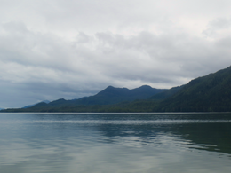
 Northern End of Pitt Island as seen from Grenville Channel | |
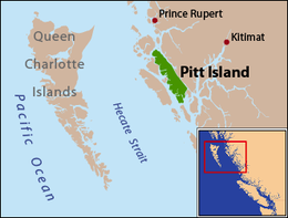 Pitt Island is located between Banks Island and the mainland. | |
| Geography | |
|---|---|
| Coordinates | 53°30′00″N 129°47′00″W / 53.50000°N 129.78333°W |
| Area | 1,368 km2 (528 sq mi) |
| Length | 90 km (56 mi) |
| Width | 8 km (5 mi) |
| Highest elevation | 962 m (3156 ft) |
| Administration | |
Canada | |
| Province | British Columbia |
Pitt Island is an island located on the north coast of British Columbia, Canada.[1]
Pitt island is located between Banks Island, across Grenville Channel (part of the Inside Passage) from the mainland, and is separated from Banks Island by Principe Channel.[2] The island has an area of 1,368 square kilometres (528 sq mi), is 90 kilometres (56 mi) long, and ranges from 8 to 23 kilometres (5.0 to 14.3 mi) wide. Its highest point is at 962 metres (3,156 ft).
Pitt Island is the only island in British Columbia known to host a resident population of moose.[3]
YouTube Encyclopedic
-
1/3Views:104 04737 3165 076
-
Treasure Hunters The Mystery of Pitt Lakes Lost Gold Mine
-
Whitestone Island Estate in British Columbia, Canada
-
Torronto-to-Vancouver flight: SW Ontario, Lake Huron, MI, Lake MI, Vancouver Coast Range 2012-07-24
Transcription
Features
- Anchor Mountain[4]
- Captain Cove[5]
- Holmes Lake[6]
- Hevenor Inlet[7]
- Newcombe Harbour[8]
- Pa-aat River[9]
- Port Stevens[10]
- Monckton Inlet[11]
- Mount Hulke[12]
- Mount Patterson[13]
- Mount Frank[14]
- Mount Saunders[15]
- Mount Shields[16]
- Wyndham Lake[17]
- Red Bluff Lake[18]
Protected Areas
- Union Passage Marine Provincial Park[19]
- Maxtaktsm'Aa/Union Passage Conservancy[20]
- Monckton Nii Luutiksm Conservancy[21]
- Pa-aat Conservancy[22]
References
Wikimedia Commons has media related to Pitt Island (British Columbia).
- ^ Iain McKechnie. Archaeological Research in Southern Gitxaała Territory, Pitt and Banks Islands, August 2009 (PDF) (Report). University of British Columbia. Retrieved 2020-06-22.
- ^ "Pitt Island". BC Geographical Names.
- ^ Price Michael H, Darimont Chris T, Winchester Neville N, Paquet Paul C (2005). "Facts from faeces: prey remains in Wolf, Canis lupus, faeces revise occurrence records for mammals of British Columbia's coastal archipelago". Canadian Field-Naturalist. 119 (2): 192–196. doi:10.22621/cfn.v119i2.105. Retrieved 2020-06-22.
- ^ "Anchor Mountain". BC Geographical Names.
- ^ "Captain Cove". BC Geographical Names.
- ^ "Holmes Lake". BC Geographical Names.
- ^ "Hevenor Inlet". BC Geographical Names.
- ^ "Newcombe Harbour". BC Geographical Names.
- ^ "Pa-aat River". BC Geographical Names.
- ^ "Port Stevens". BC Geographical Names.
- ^ "Monckton Inlet". BC Geographical Names.
- ^ "Mount Hulke". BC Geographical Names.
- ^ "Mount Patterson". BC Geographical Names.
- ^ "Mount Frank". BC Geographical Names.
- ^ "Mount Saunders". BC Geographical Names.
- ^ "Mount Shields". BC Geographical Names.
- ^ "Wyndham Lake". BC Geographical Names.
- ^ "Red Bluff Lake". BC Geographical Names.
- ^ "Union Passage Marine Park". BC Geographical Names.
- ^ "Maxtaktsm'Aa/Union Passage Conservancy". BC Geographical Names.
- ^ "Monckton Nii Luutiksm Conservancy". BC Geographical Names.
- ^ "Pa-aat Conservancy". BC Geographical Names.