
Pishan County
Guma | |
|---|---|
 | |
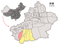 Location of Pishan/Guma County (red) within Hotan Prefecture (yellow) and Xinjiang | |
 Guma Location of the seat in Xinjiang  Guma Guma (Xinjiang)  Guma Guma (China) | |
| Coordinates: 37°37′N 78°17′E / 37.62°N 78.28°E | |
| Country | China |
| Autonomous region | Xinjiang |
| Prefecture | Hotan |
| County seat | Guma Town |
| Area | |
| • Total | 39,741.52 km2 (15,344.29 sq mi) |
| Population (2020)[3] | |
| • Total | 281,573 |
| • Density | 7.1/km2 (18/sq mi) |
| Ethnic groups | |
| • Major ethnic groups | Uyghur[4][5] |
| Time zone | UTC+8 (China Standard[a]) |
| Postal code | 845100 |
| Website | www |
| Pishan County | |||||||||||
|---|---|---|---|---|---|---|---|---|---|---|---|
| Uyghur name | |||||||||||
| Uyghur | گۇما ناھىيىسى | ||||||||||
| |||||||||||
| Chinese name | |||||||||||
| Simplified Chinese | 皮山县 | ||||||||||
| Traditional Chinese | 皮山縣 | ||||||||||
| |||||||||||
| Alternative Chinese name | |||||||||||
| Simplified Chinese | 固玛县 | ||||||||||
| Traditional Chinese | 固瑪縣 | ||||||||||
| |||||||||||
Pishan County (Chinese: 皮山县) as the official romanized name, also transliterated from Uyghur as Guma County (Uyghur: گۇما ناھىيىسى; Chinese: 固玛县), is a county within the Xinjiang Uyghur Autonomous Region and is under the administration of the Hotan Prefecture. It contains an area of 39,412 km2 (15,217 sq mi). According to the 2002 census, it has a population of 220,000. The county borders Maralbexi County and Makit County to the north, Karakax County, Hotan County and Kunyu to the east and Kargilik County to the west. The county includes lands near the Karakoram Pass which are part of the Aksai Chin area that is disputed between China and India.
YouTube Encyclopedic
-
1/2Views:4 78539 786
-
Tursun Ybyraiym, Kangkir Kyrgyz Township, Pishan (Guma) County, Xinjiang, PRC. 26.7.2015.
-
Mairam Nisamet Tokto, Baskak (Basikake) village, Pishan (Guma) County, Xinjiang, PRC. 26.7.2015.
Transcription
History
In 1902, Pishan County was created from Guma, Sanju and other areas originally part of Kargilik.[1]
In March 1950, the Pishan County People's Government was established.[4]
In May 2010, Shahidulla (Xaidula/Saitula) was made a town.[1]
On the night of December 28, 2011, Koxtag (Kuoshi Tage) in Pishan was the site of the 2011 Pishan hostage crisis.
In 2012/3, Muji was changed from a township into a town.[1][6]
On July 3, 2015, the 2015 Pishan earthquake occurred, killing three and wounding 71.
On July 24, 2015, Koxtag was changed from a township to a town.[7]
On January 9, 2016, Sanju was changed from a township to a town.[8]
Geography
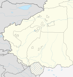
The northern part of Pishan/Guma County is made up of sand dunes in the Taklamakan Desert. The main part of the population of the county is grouped around oasis areas at the base of the Kunlun Mountains. The southern part of the county is mountainous including the Qizil Koran Range. A prominent mountain pass in the area is Sanju Pass. A prominent lake in the area is Cuolule Co (Cuolule Cuo, Tsorūl Tso; 错鲁勒错).
Climate
| Climate data for Pishan (1991–2020 normals, extremes 1981–2010) | |||||||||||||
|---|---|---|---|---|---|---|---|---|---|---|---|---|---|
| Month | Jan | Feb | Mar | Apr | May | Jun | Jul | Aug | Sep | Oct | Nov | Dec | Year |
| Record high °C (°F) | 19.1 (66.4) |
21.2 (70.2) |
31.1 (88.0) |
35.0 (95.0) |
37.1 (98.8) |
40.3 (104.5) |
41.6 (106.9) |
40.6 (105.1) |
36.0 (96.8) |
29.7 (85.5) |
25.1 (77.2) |
18.7 (65.7) |
41.6 (106.9) |
| Mean daily maximum °C (°F) | 1.0 (33.8) |
7.0 (44.6) |
16.4 (61.5) |
24.1 (75.4) |
28.3 (82.9) |
31.8 (89.2) |
33.5 (92.3) |
32.1 (89.8) |
27.7 (81.9) |
21.0 (69.8) |
12.2 (54.0) |
3.4 (38.1) |
19.9 (67.8) |
| Daily mean °C (°F) | −5.2 (22.6) |
0.8 (33.4) |
9.6 (49.3) |
16.9 (62.4) |
21.0 (69.8) |
24.5 (76.1) |
26.0 (78.8) |
24.8 (76.6) |
20.3 (68.5) |
12.9 (55.2) |
4.6 (40.3) |
−2.9 (26.8) |
12.8 (55.0) |
| Mean daily minimum °C (°F) | −10.6 (12.9) |
−4.9 (23.2) |
3.3 (37.9) |
10.1 (50.2) |
14.4 (57.9) |
18.0 (64.4) |
19.6 (67.3) |
18.6 (65.5) |
13.6 (56.5) |
5.6 (42.1) |
−1.8 (28.8) |
−8.2 (17.2) |
6.5 (43.7) |
| Record low °C (°F) | −22.8 (−9.0) |
−22.0 (−7.6) |
−8.4 (16.9) |
−0.1 (31.8) |
4.1 (39.4) |
9.1 (48.4) |
11.6 (52.9) |
9.4 (48.9) |
1.7 (35.1) |
−4.7 (23.5) |
−13.3 (8.1) |
−22.1 (−7.8) |
−22.8 (−9.0) |
| Average precipitation mm (inches) | 2.7 (0.11) |
2.4 (0.09) |
2.7 (0.11) |
4.0 (0.16) |
16.6 (0.65) |
10.3 (0.41) |
11.4 (0.45) |
8.7 (0.34) |
5.4 (0.21) |
0.6 (0.02) |
1.6 (0.06) |
1.2 (0.05) |
67.6 (2.66) |
| Average precipitation days (≥ 0.1 mm) | 2.3 | 1.8 | 1.2 | 1.5 | 2.7 | 3.6 | 3.9 | 3.0 | 1.9 | 0.4 | 0.6 | 1.8 | 24.7 |
| Average snowy days | 5.1 | 2.8 | 0.6 | 0.1 | 0 | 0 | 0 | 0 | 0 | 0 | 0.6 | 3.7 | 12.9 |
| Average relative humidity (%) | 57 | 47 | 33 | 30 | 34 | 37 | 41 | 43 | 45 | 43 | 45 | 56 | 43 |
| Mean monthly sunshine hours | 178.8 | 173.3 | 210.1 | 229.7 | 269.0 | 280.2 | 274.4 | 243.3 | 244.0 | 263.0 | 220.2 | 180.6 | 2,766.6 |
| Percent possible sunshine | 58 | 56 | 56 | 57 | 61 | 64 | 62 | 59 | 67 | 77 | 74 | 61 | 63 |
| Source: China Meteorological Administration[9][10] | |||||||||||||
Administrative divisions
The county is made up of 1 subdistrict, 6 towns, 8 townships, 2 ethnic townships, and two other areas:[1][6][11]
| Name | Simplified Chinese | Hanyu Pinyin | Uyghur (UEY) | Uyghur Latin (ULY) | Administrative division code | Notes | |
|---|---|---|---|---|---|---|---|
| Subdistrict | |||||||
| Pishan County Subdistrict | 皮山县街道 | Píshān Xiàn Jiēdào | گۇما كوچا باشقارمىسى | guma kocha bashqarmisi | 653223001 | ||
| Towns | |||||||
| Guma Town | 固玛镇 | Gùmǎ Zhèn | گۇما بازىرى | guma baziri | 653223100 | ||
| Duwa Town | 杜瓦镇 | Dùwǎ Zhèn | دۇۋا بازىرى | duwa baziri | 653223101 | ||
| Shahidulla Town | 赛图拉镇 | Sàitúlā Zhèn | شەيدۇللا بازىرى | sheydulla baziri | 653223102 | ||
| Muji Town | 木吉镇 | Mùjí Zhèn | مۇجى بازىرى | muji baziri | 653223103 | formerly Muji Township (مۇجى يېزىسى / 木吉乡) | |
| Koxtag Town[12] | 阔什塔格镇 | Kuòshítǎgé Zhèn | قوشتاغ بازىرى | qoshtagh baziri | 653223104 | formerly Koxtag Township (قوشتاغ يېزىسى / 阔什塔格乡) | |
| Sanju Town | 桑株镇 | Sāngzhū Zhèn | سانجۇ بازىرى | sanju baziri | 653223105 | formerly Sanju Township (سانجۇ يېزىسى / 桑株乡) | |
| Towns | |||||||
| Kilian Township | 克里阳乡 | Kèlǐyáng Xiāng | كىلىياڭ يېزىسى | kiliyang yëzisi | 653223201 | ||
| Kokterak Township | 科克铁热克乡 | Kēkètiěrèkè Xiāng | كۆكتېرەك يېزىسى[13] | köktërek yëzisi | 653223202 | ||
| Choda Township | 乔达乡 | Qiáodá Xiāng | چودا يېزىسى | choda yëzisi | 653223205 | ||
| Mokoyla Township (Mo-kuei-la[14]) |
木奎拉乡 | Mùkuílā Xiāng | موكويلا يېزىسى | mokoyla yëzisi | 653223206 | ||
| Zangguy Township | 藏桂乡 | Zàngguì Xiāng | زاڭگۇي يېزىسى | zangguy yëzisi | 653223207 | ||
| Piyalma Township | 皮亚勒玛乡 | Píyàlèmǎ Xiāng | پىيالما يېزىسى | piyalma yëzisi | 653223208 | ||
| Pixna Township[15] | 皮西那乡 | Píxīnà Xiāng | پىشنا يېزىسى | pishna yëzisi | 653223209 | ||
| Bashlengger Township | 巴什兰干乡 | Bāshénlángàn Xiāng | باشلەڭگەر يېزىسى | bashlengger yëzisi | 653223210 | ||
| Ethnic townships | |||||||
| Nawabat Tajik Ethnic Township | 垴阿巴提塔吉克民族乡 | Nǎo'ābātí Tǎjíkè Mínzúxiāng | ناۋئابات تاجىك يېزىسى | naw'abat tajik yëzisi | 653223211 | (Sarikoli) ناۇئاباد تۇجىك دىيۇر Nouobod Tujik diyur[b]
| |
| Kangkir Kyrgyz Ethnic Township | 康克尔柯尔克孜民族乡 | Kāngkè'ěr Kē'ěrkèzī Mínzúxiāng | كەڭقىر قىرغىز يېزىسى | kengqir qirghiz yëzisi | 653223212 | (Kyrgyz) كەڭقىر قىرعىز ايىلى Кеңқыр Кыргыз айылы | |
Other:
- Pishan Sanxia Industrial Park (سەنشىيا گۇما ناھىيىلىك باغچىلاشقان سانائەت رايونى, 皮山三峡工业园区)
Economy

The county produces rice, wheat, cotton, apricots, peaches, grapes, silkworms and furs. Coal, gypsum and mica are mined in the county. Industries include tractor repair, carpet making and food processing. Local specialities include sangpi paper and walnuts.[2]
As of 1885[update], there was about 54,600 acres (360,891 mu) of cultivated land in Guma.[17]
Demographics
| Year | Pop. | ±% p.a. |
|---|---|---|
| 2000 | 216,024 | — |
| 2010 | 258,210 | +1.80% |
| [1][18] | ||
In the late 2010s, ethnic minorities made up 98.4% of the population of the county,[4] mainly Uyghurs.[18] In 2011, Han Chinese accounted for less than 2% of the population of Pishan.[19]
As of 2015, 290,016 of the 296,075 residents of the county were Uyghur, 3,788 were Han Chinese and 2,271 were from other ethnic groups.[20]
As of 1999, 97.85% of the population of Guma (Pishan) County was Uyghur and 1.32% of the population was Han Chinese.[21]
Transportation
Notable persons
- Ablajan Awut Ayup, pop singer
- Ghojimuhemmed Muhemmed, modern poet
- Osmanjan Muhemmed Pas’an, modern poet
Historical maps
-
![Map including Cuolule Co (labeled as Tsorūl Tso) in southern Pishan County (AMS, 1955)[c]](/wikipedia/commons/thumb/a/ab/Map_India_and_Pakistan_1-250%2C000_Tile_NI_44-1_Tsorul_Tso.jpg/317px-Map_India_and_Pakistan_1-250%2C000_Tile_NI_44-1_Tsorul_Tso.jpg)
-
![Map including Pishan (labeled as P’I-SHAN (GUMA BAZAR)) and the northern part of the county (USATC, 1971)[d]](/wikipedia/commons/thumb/0/00/Txu-oclc-6654394-nj-44-3rd-ed.jpg/220px-Txu-oclc-6654394-nj-44-3rd-ed.jpg)
-
 Map including part of southern Guma (Pishan) County (DMA, 1973)
 -
![Map including the southern part of the county and areas disputed between China and India (AMS, 1950)[e]](/wikipedia/commons/thumb/3/34/Txu-oclc-6654394-ni-44-3rd-ed.jpg/256px-Txu-oclc-6654394-ni-44-3rd-ed.jpg)
-
![Map including Pishan (labeled as PISHAN (P’I-SHAN)) and surrounding region (DMA, 1980)[f]](/wikipedia/commons/thumb/f/fb/Operational_Navigation_Chart_G-7%2C_6th_edition.jpg/331px-Operational_Navigation_Chart_G-7%2C_6th_edition.jpg)
Notes
- ^ Locals in Xinjiang frequently observe UTC+6 (Xinjiang Time), 2 hours behind Beijing.
- ^ There is no official orthography for Sarikoli in China. This is the spelling used in the Sarikoli-Chinese dictionary written by linguist Gao Erqiang.[16]
- ^ From map: "THE DELINEATION OF INTERNATIONAL BOUNDARIES ON THIS MAP MUST NOT BE CONSIDERED AUTHORITATIVE"
- ^ From map: "DELINEATION OF INTERNATIONAL BOUNDARIES MUST NOT BE CONSIDERED AUTHORITATIVE".
- ^ From map: "THE DELINEATION OF INTERNATIONAL BOUNDARIES ON THIS MAP MUST NOT BE CONSIDERED AUTHORITATIVE.".
- ^ From map: "The representation of international boundaries is not necessarily authoritative."
References
- ^ a b c d e f 皮山县历史沿革 [Pishan County Historical Development] (in Simplified Chinese). XZQH.org. 2 December 2014. Retrieved 29 December 2019.
光绪二十八年(1902年)由叶城县析固玛、桑株等三十八庄置皮山县,县治固玛,隶属莎车府。{...}2000年第五次人口普查,皮山县常住总人口216024人,{...}2003年,全县总面积39741.52平方千米,{...}2010年5月,自治区政府批准设立赛图拉镇。2010年第六次人口普查,皮山县常住总人口258210人,其中:街道办事处18424人,固玛镇28163人,杜瓦镇8631人,县直辖村镇1199人,阔什塔格乡15200人,克里阳乡6414人,科克铁热克乡35414人,桑株乡30906人,木吉乡23273人,乔达乡12450人,木奎拉乡19591人,藏桂乡13727人,皮亚勒玛乡6094人,皮西那乡7496人,巴什兰干乡4862人,瑙阿巴提塔吉克民族乡932人,康克尔柯尔克孜民族乡1902人,国营牧场1005人,兵团皮山农场22527人。 2012年,自治区政府(新政函[2012]364号)批准撤销木吉乡,设立木吉镇(2013年实施,皮政发[2013]8号)。调整后,全县辖4个镇、12个乡(其中2个民族乡):固玛镇、杜瓦镇、赛图拉镇、木吉镇、阔什塔格乡、克里阳乡、科克铁热克乡、桑株乡、乔达乡、木奎拉乡、藏桂乡、皮亚勒玛乡、皮西那乡、巴什兰干乡、垴阿巴提塔吉克族乡、康克尔柯尔克孜族乡。
- ^ a b 夏征农; 陈至立, eds. (September 2009). 辞海:第六版彩图本 [Cihai (Sixth Edition in Color)] (in Chinese). 上海. Shanghai: 上海辞书出版社. Shanghai Lexicographical Publishing House. p. 1726. ISBN 9787532628599.
面积3.97万平方米。{...}农、牧业均盛,产玉米、小麦、棉花、杏、桃、葡萄、蚕、毛皮等。矿产有煤、石膏、云母。工业有农机修造、地毯编织、食品加工等。特产桑皮纸、核桃。
- ^ Xinjiang: Prefectures, Cities, Districts and Counties
- ^ a b c 皮山概况. 皮山县人民政府. Retrieved 29 December 2019.
1950年3月,皮山县人民政府成立。{...}目前,全县总人口25.8万人,少数民族占98.4%。
- ^ 1997年皮山县行政区划 [1997 Guma County Administrative Divisions]. XZQH.org. 6 January 2011. Retrieved 3 April 2020.
面积41167平方千米,人口20.2万,有维吾尔、汉、塔吉克、柯尔克孜等民族,辖2镇13乡。{...}有维吾尔、汉等民族。{...},均系维吾尔族。{...}有维吾尔、柯尔克孜等民族,
- ^ a b 行政区划. 皮山县人民政府 (in Simplified Chinese). 18 November 2018. Retrieved 29 December 2019.
皮山县辖6个镇、10个乡(包括2个民族乡):固玛镇、杜瓦镇、阔什塔格镇(2015年)、克里阳乡、科克铁热克乡、桑株镇(2016年)、木吉镇(2013年)、乔达乡、木奎拉乡、藏桂乡、皮亚勒玛乡、皮西那乡、巴什兰干乡、赛图拉镇、垴阿巴提塔吉克族乡、康克尔柯尔克孜族乡。
- ^ 关于同意皮山县阔什塔格乡撤乡设镇的批复(新政函【2015】187号). 新疆民政 (in Simplified Chinese). 30 July 2015. Archived from the original on 21 September 2017. Retrieved 30 December 2019.
- ^ 关于同意皮山县桑株乡撤乡设镇的批复. The Government of Xinjiang Uygur Autonomous Region of China (in Simplified Chinese). 12 January 2016. Archived from the original on 21 September 2017. Retrieved 30 December 2019.
- ^ 中国气象数据网 – WeatherBk Data (in Simplified Chinese). China Meteorological Administration. Retrieved 10 October 2023.
- ^ "Experience Template" 中国气象数据网 (in Simplified Chinese). China Meteorological Administration. Retrieved 10 October 2023.
- ^ 2018年统计用区划代码和城乡划分代码:皮山县 [2018 Statistical Area Numbers and Rural-Urban Area Numbers: Pishan County] (in Simplified Chinese). National Bureau of Statistics of the People's Republic of China. 2018. Retrieved 29 December 2019.
统计用区划代码 名称 653223001000 街道办事处 653223100000 固玛镇 653223101000 杜瓦镇 653223102000 赛图拉镇 653223103000 木吉镇 653223104000 阔什塔格镇 653223105000 桑株镇 653223201000 克里阳乡 653223202000 科克铁热克乡 653223205000 乔达乡 653223206000 木奎拉乡 653223207000 藏桂乡 653223208000 皮亚勒玛乡 653223209000 皮西那乡 653223210000 巴什兰干乡 653223211000 垴阿巴提塔吉克民族乡 653223212000 康克尔柯尔克孜民族乡 653223401000 皮山三峡工业园区 653223500000 兵团皮山农场
- ^ Koxtag (Approved - N) at GEOnet Names Server, United States National Geospatial-Intelligence Agency
- ^ زۇلخۇمار تۇردى مەسئۇل, ed. (29 September 2019). ئاپتونوم رايونىمىزدىن مەملىكەت بويىچە مىللەتلەر ئىتتىپاقلىقى-تەرەققىياتىدىكى نەمۇنىلىك كوللېكتىپ ۋە نەمۇنىچى شەخسلەرنىڭ ئىسىملىكى. جۇڭگو قەشقەر تورى (in Uyghur). Retrieved 13 May 2020.
.28خوتەن ۋىلايىتىنىڭ گۇما ناھىيەسى كۆكتېرەك يېزىسى بەلقۇم كەنتى كەنت ئاھالە كومىتېتى
- ^ "NJ 44 Ho-tien". Washington, D. C.: U.S. Army Topographic Command. 1971 – via Perry–Castañeda Library Map Collection.
P'I-SHAN (GUMA BAZAR){...}Mo-kuei-la
- ^ Pixna (Approved - N) at GEOnet Names Server, United States National Geospatial-Intelligence Agency
- ^ Gao, Erqiang (高尔锵) (1996). 塔吉克汉词典 [Tajik-Chinese Dictionary] (in Simplified Chinese). Chengdu: Sichuan Nationalities Publishing House (四川民族出版社). ISBN 978-7-5409-1744-9.
- ^ Herold J. Wiens (November 1966). "Cultivation Development and Expansion in China's Colonial Realm in Central Asia". The Journal of Asian Studies. 26 (1): 75. doi:10.2307/2051832. JSTOR 2051832. S2CID 162339064.
- ^ a b ying (ed.). "Xinjiang earthquake kills 3, injures 71". Xinhua News Agency. Archived from the original on 6 July 2015. Retrieved 4 July 2015.
With a population of 258,000, the county is mainly inhabited by people of Uygur ethnicity.
- ^ Wong, Edward (2011-12-30). "Reports Describe Deadly Shootout in Restive Region of China". The New York Times. Retrieved 2011-12-30.
The Han make up less than 2 percent of the population in Pishan.
- ^ 3-7 各地、州、市、县(市)分民族人口数 (in Simplified Chinese). شىنجاڭ ئۇيغۇر ئاپتونوم رايونى 新疆维吾尔自治区统计局 Statistic Bureau of Xinjiang Uygur Autonomous Region. 15 March 2017. Archived from the original on 11 October 2017. Retrieved 3 September 2017.
- ^ Morris Rossabi, ed. (2004). Governing China's Multiethnic Frontiers (PDF). University of Washington Press. p. 180. ISBN 0-295-98390-6.