
Piraeus
Νομός Πειραιά | |
|---|---|
Former prefecture | |
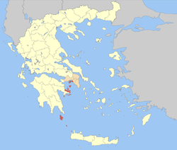 Location of Piraeus in Greece | |
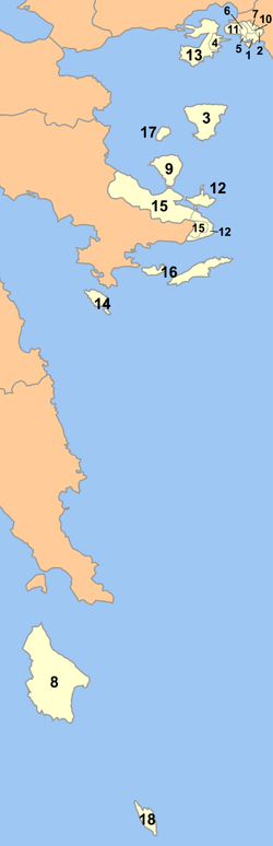 Location of municipalities within Piraeus Prefecture | |
| Country | Greece |
| Periphery | Attica |
| Established | 1972 |
| Disestablished | 2010 |
| Capital | Piraeus |
| Subdivisions | List |
| Area | |
| • Total | 929 km2 (359 sq mi) |
| • Rank | 47th |
| Population (2001) | |
| • Total | 541,504 |
| • Rank | 3rd |
| • Density | 580/km2 (1,500/sq mi) |
| • Rank | 2nd |
| Postal codes | 1xx xx, 801 xx |
| Area codes | 21x, 2736 |
| ISO 3166 code | GR-A4 |
| Vehicle registration | ΥΝ |
| Website | nomarhiapeiraia.gr |
Piraeus Prefecture (Greek: Νομός Πειραιά or Νομός Πειραιώς) was one of the prefectures of Greece. Created in 1964 as a separate Prefecture (Νομός) and after the dissolution of the prefecture in 1972 was one of the 4 prefectures (Νομαρχίες) of Attica prefecture, and from 1994, part of the Athens-Piraeus super-prefecture (1994–2011). The capital of the prefecture was Piraeus. As a part of the 2011 Kallikratis government reform, the prefecture was abolished, and its territory was divided into two regional units: Islands and Piraeus.
YouTube Encyclopedic
-
1/3Views:23 535891336
-
The port of Piraeus, zea Limani & Mikrolimano (Αθήνα/Athens)
-
Pireas from air - Πειραιάς - Greece
-
From Faliro to Piraeus
Transcription
History
The prefecture covered the south-western part of the agglomeration of Athens, several islands in the Saronic Gulf (Salamis, Aegina, Agkistri, Poros, Hydra, Dokos, Spetses, Spetsopoula), Methana and Troizina on the Peloponnese peninsula, and the islands of Kythira and Antikythera south of the Peloponnese. An indication of the geographical diversity of the prefecture was the stark difference in population density between its seven mainland municipalities in the Athens urban area, which have 9,244.2 inhabitants/km2, and its detached outlying areas, which average only 85.83 inhabitants/km2 (and most of these on Salamis Island, at 395.40/km2, while the far-outlying parts have only 47.80/km2).[citation needed]
Municipalities and communities
| Municipality | # on map opposite |
Greek name | Seat (if different) |
YPES code |
|---|---|---|---|---|
| Aegina | 3 | Αίγινα | 4003 | |
| Agios Ioannis Rentis | 2 | Άγιος Ιωάννης Ρέντη | 4001 | |
| Agkistri | 17 | Αγκίστρι | Megalochóri | 4002 |
| Ampelakia | 4 | Αμπελάκια | 4004 | |
| Antikythera | 18 | Αντικύθηρα | Potamós | 4005 |
| Drapetsona | 5 | Δραπετσώνα | 4006 | |
| Hydra | 16 | Ύδρα | 4018 | |
| Keratsini | 6 | Κερατσίνι | 4007 | |
| Korydallos | 7 | Κορυδαλλός | 4008 | |
| Kythira | 8 | Κύθηρα | 4009 | |
| Methana | 9 | Μέθανα | 4010 | |
| Nikaia | 10 | Νίκαια | 4011 | |
| Perama | 11 | Πέραμα | 4013 | |
| Piraeus | 1 | Πειραιάς | 4012 | |
| Poros | 12 | Πόρος | 4014 | |
| Salamina (Salamis) | 13 | Σαλαμίνα | 4015 | |
| Spetses | 14 | Σπέτσες | 4016 | |
| Troizina | 15 | Τροιζήνα | Galatas, Troizina | 4017 |
Provinces
- Province of Salamis - Salamina
- Province of Aegina - Aegina
- Province of Troizinia - Methana
- Province of Hydra and Spetses - Hydra
- Province of Kythira - Kythira
- Province of Piraeus - Piraeus
Note: Provinces no longer hold any legal status in Greece.
References
External links
- (in Greek) Official website
37°57′N 23°38′E / 37.950°N 23.633°E